- Home
- :
- All Communities
- :
- Products
- :
- Mapping
- :
- Mapping Questions
- :
- Re: changing coordinate systems
- Subscribe to RSS Feed
- Mark Topic as New
- Mark Topic as Read
- Float this Topic for Current User
- Bookmark
- Subscribe
- Mute
- Printer Friendly Page
changing coordinate systems
- Mark as New
- Bookmark
- Subscribe
- Mute
- Subscribe to RSS Feed
- Permalink
Greetings....I have received a mdx file from an outside source. It is in NAD 1983 UTM 15N. I would like to work in it using a state plane coordinate system. Can someone tell me how to change that? Thanks
- Mark as New
- Bookmark
- Subscribe
- Mute
- Subscribe to RSS Feed
- Permalink
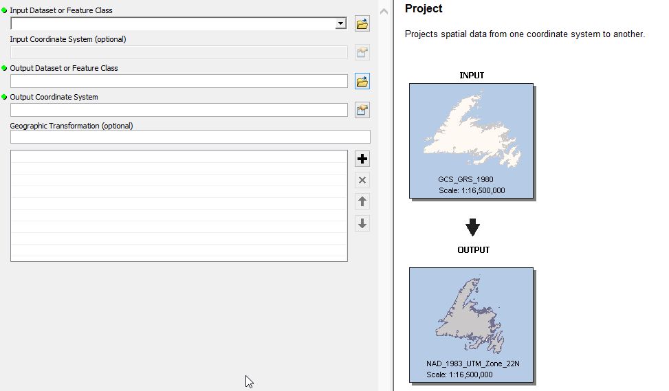
Change the projection with the "Project" tool:
- Mark as New
- Bookmark
- Subscribe
- Mute
- Subscribe to RSS Feed
- Permalink
Follow what Arnold Kuilman said. If it is in NAD 1983 UTM 15N, be sure to choose that as well when you get to the "Project" screen. Then choose the one you would like for the "Output Coordinate System".
- Mark as New
- Bookmark
- Subscribe
- Mute
- Subscribe to RSS Feed
- Permalink
Can someone in this thread tell me why I can’t see a reply button , or have the ability to upload files? I am having to reply thru email.
- Mark as New
- Bookmark
- Subscribe
- Mute
- Subscribe to RSS Feed
- Permalink
The other replies discuss how to create copies of vector data layers in a new coordinate system. You can also change the map's coordinate system in ArcMap. Because I think you've received an mxd, rather than a mdx, file.
In ArcMap, open the data frame properties by right-clicking Layers in the table of contents. Select the Coordinate System tab. The current coordinate system will be listed, and you can use the directory tree to browse to the coordinate system that you want to use. If there's a search box, and you know the well-known ID of the State Plane zone that you want to use, you can search on that.
Melita
- Mark as New
- Bookmark
- Subscribe
- Mute
- Subscribe to RSS Feed
- Permalink
Melita…..you are correct about the file extension, sorry about that. Also, I did as you suggested to change the coord system. Checking the properties, I now see the state plane system, but looking at the lower right corner of my display, it is still tracking meters. Any way I can change that?
- Mark as New
- Bookmark
- Subscribe
- Mute
- Subscribe to RSS Feed
- Permalink
Hi Mike,
Open the data frame properties again, and select the General tab. In the middle, you'll see pull-downs for map units and display units. The map units are set by the data frame's coordinate system, but you can change the display units.
A tip: you can control the precision of the status bar display via another control. From the Customize menu, select ArcMap Options. Select Data View tab. In the "Coordinate Display in Status Bar" section, you can change the decimal places.
- Mark as New
- Bookmark
- Subscribe
- Mute
- Subscribe to RSS Feed
- Permalink
Thanks Melita….great help!
- Mark as New
- Bookmark
- Subscribe
- Mute
- Subscribe to RSS Feed
- Permalink
a question about the "project" tool mentioned above: I would like to project the entire map (all layers). The project tool only allow me to do one at a time. Is there a tool where I can project more than 1 layer at once? Thanks
- Mark as New
- Bookmark
- Subscribe
- Mute
- Subscribe to RSS Feed
- Permalink
Yes, assuming you want to project all of them the same?
Try this link. It explains one way.
There is another way as well, but this one should work?