- Home
- :
- All Communities
- :
- Products
- :
- Mapping
- :
- Mapping Questions
- :
- Arrows pointing to point features
- Subscribe to RSS Feed
- Mark Topic as New
- Mark Topic as Read
- Float this Topic for Current User
- Bookmark
- Subscribe
- Mute
- Printer Friendly Page
Arrows pointing to point features
- Mark as New
- Bookmark
- Subscribe
- Mute
- Subscribe to RSS Feed
- Permalink
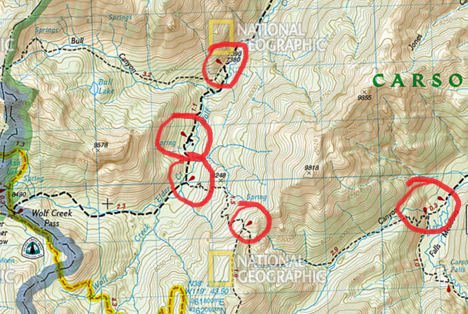
I'm working on a trail map and would like to illustrate trail segments and their corresponding distances. In order to clearly indicate the segments, I would like to use arrows like the attached example. I have created point features where all of the segments begin and end using the intersect tool, but now I would like to figure out how to place arrows like the example (see red circles). Ideally, the arrows should be angled so as to avoid overlapping the linear trail features. Does anyone know how I might be able to do this?
- Mark as New
- Bookmark
- Subscribe
- Mute
- Subscribe to RSS Feed
- Permalink
You can use a symbol (or picture marker symbol) and use the rotation setting on the symbols:
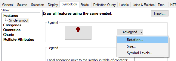

The challenge may be in the offset of the symbol to the actual point location. You can use X and Y offsetting in the properties of the symbol, but this does not give correct results when applying rotation.

... and the effect on large rotation angles:

An alternative could be creating rotation angle classes (for instance each 30°) and define a symbol with the proper offset for each symbol.

- Mark as New
- Bookmark
- Subscribe
- Mute
- Subscribe to RSS Feed
- Permalink
Thank you for the reply. It looks like the key to making this work is having a field with the rotation angle for each symbol. Correct?
- Mark as New
- Bookmark
- Subscribe
- Mute
- Subscribe to RSS Feed
- Permalink
Yes, that is correct. However, if you have an offset of the symbol to the point location, you may have to create different classes and define symbols for each class.
- Mark as New
- Bookmark
- Subscribe
- Mute
- Subscribe to RSS Feed
- Permalink
this location is for help about GeoNet the community structure is here
You can move your question here Geoprocessing to get full coverage should any of the responses not work