Mapping Blog - Page 2

cancel
Showing results for 
Show  only  | Search instead for 
Did you mean: 

Latest Activity

(17 Posts)
BojanŠavrič
Esri Contributor

Here is a story map‌ about map projections in ArcGIS:
https://storymaps.arcgis.com/stories/ea0519db9c184d7e84387924c84b703f

It shows a gallery of 68 map projections supported by projection-engine‌ in ArcGIS 10.7.1 and ArcGIS Pro 2.4.

Happy mapping!

more
2 0 861
BojanŠavrič
Esri Contributor

The Equal Earth, an equal-area projection, and the Peirce quincuncial, a conformal projection, are now available in ArcGIS 10.7 and ArcGIS Pro 2.3.

The Equal Earth is an equal-area pseudocylindrical projection for world maps. It shows a pleasant appearance of the land features and its shape is similar to the well-known Robinson projection. The projection is appropriate for mapping global phenomena or for any other thematic world map that requires areas at their true relative sizes. It was jointly developed by Tom Patterson (US National Park Service, ret.), Bernhard Jenny (Monash University) and Bojan Šavrič (Esri) in 2018. It was published in IJGIS. Some behind-the-scenes look at how (and why!) it was created can also be found in ArcUser article.

The Equal Earth map projection

Equal Earth in use:

Political and physical wall maps by Tom Patterson
The Living Land by Esri Story Maps team

40 Years of Nautical Piracy by John Nelson

The Peirce quincuncial map projection shows the world in a square. The projection is conformal except in the middle of the four sides of the square. It was developed by Charles S. Peirce in 1879. In his original design, the projection is centered at the North Pole, which displays the equator as a square rotated relative to the projection edge. The original implementation was on a sphere. Esri's implementation of this projection maintains its conformal properties on ellipsoids also such as WGS 1984. The projection can be tessellated or mosaicked.

The Peirce quincuncial projection shown in square and diamond orientations.

Happy projecting! 

Cover photo by John Nelson

more
1 0 1,421
EdiePunt
Esri Contributor

Welcome and thanks for joining the Map Advice Community group on GeoNet! To get started we invite you to first review the group features on the overview page and familiarize yourself with the group info, admins and GeoNet 101 information in the left column.

The Map Advice group is a place to share your cartographic work, or your works-in-progress. Ask for opinions, advice, or full critiques on your maps, be they in web map, app, pdf, or just screenshot. Share tips and tricks that you've found make for great cartography. Share links to great maps you use as inspiration. As you explore the group, you’ll find tools to connect and collaborate. Use them to share files, create blogs, ask/answer questions and read the latest blogs posts and join discussions.


We’d like to get to know you, so we invite you to post a comment below to say “hello" and introduce yourself and share what you’re looking forward to contributing to the Map Advice Community group .  


We’re excited to connect and collaborate with you and we look forward to seeing your contributions. Let's get started with some mapping!


Edie Punt and David Watkins, group admins

more
4 1 825
BojanŠavrič
Esri Contributor

ArcGIS 10.4 now supports eight small-scale map projections displayed in an animated gif:

Compact Miller
Patterson
Natural Earth
Natural Earth II
Wagner IV
Wagner V
Wagner VII
Eckert-Greifendorff

The Eckert-Greifendorff, Wagner IV and Wagner VII are equal-area projections; the remaining five are compromise projections that try to minimize overall distortion. Sample definitions for the first seven projections are available in the Projected Coordinate Systems\World  and Projected Coordinate Systems\World(Sphere-based) folders.

The Eckert-Greifendorff, Wagner IV and Wagner VII also support ellipsoidal equations. Gnomonic, quartic authalic and Hammer projections are now available in ellipsoidal forms too.

With Eckert-Greifendorff, Hammer ellipsoidal, quartic authalic ellipsoidal, Wagner IV, and Wagner VII, one can select a custom central latitude and create oblique aspects of the projections.

New-Projections-ArcGIS-10.4.gif

ArcGIS 10.4 includes three variants of polar stereographic projection (variant A, B and C – EPSG codes 9810, 9829 and 9830 respectively) and two new variants of Mercator projection (variant A and C – EPSG codes 9804 and 1044 respectively). Mercator variant B (EPSG code 9805) was already included before as Mercator projection.

Mercator variants A and B have origin of northings / Y values at the equator. Variant A uses a scale factor at the equator to reduce overall scale distortion and effectively defines two standard parallels that are symmetric around the equator. Variant B takes a standard parallel and effectively forces the scale factor at the equator to be less than one. Variant C is similar to variant B, but with the addition of a latitude of origin. The origin of northings / Y values occurs at the latitude of origin.

The polar stereographic variant A is centered at a pole. The longitude of origin defines which longitude will be going straight “down” from the North Pole or “up” from the “South Pole” towards the middle of the map. A scale factor reduces the overall scale distortion and effectively defines a standard parallel. The variant B is similar to variant A, only that it takes a standard parallel to reduce the overall scale distortion of the projection and results in a scale factor at the pole of less than one. Variant C is similar to variant B, but with the addition of a latitude of origin. The origin of northings / Y values occurs at the intersection of the latitude of origin and the longitude of origin.

more
4 6 4,248
ChadKopplin
Occasional Contributor III

Yesterday I ran into an issue plotting well sites across the state.  When I zoomed to the full extent of the shapefile that I created from a txt file, I noticed many of the locations showing up in Asia, this is very common, these records were missing the negative in front of the Longitude values to place them in my state.  I thought no problem, I will add a new field and calculate it equal to a negative and the old field.  This worked beautifully just like I expected.  I re added the txt document to my map and still saw the sites in Asia.  When I identified the sites, what did I see, my new values were positives, because when I performed the calculation all of my correct records that all ready had a negative changed to a positive with my new negative that I added.  So, my daughter has been working on integers lately in math, and she will get a kick out of this when I tell her the I messed up my locations, because I did not pay attention to the signs.  I hope I gave you a good laugh or at least a chuckle.  Have a great day.

more
0 0 422
RichardFairhurst
MVP Honored Contributor

Google has added 25 million buildings in the United States this year to their Map view.  These building outlines can be converted to polygons in ArcGIS if you have Photoshop and do the following steps:

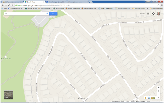
1.      Locate an area with buildings in Google Maps with the Map view on.  Maximize the browser window.  Zoom until you are at least at the second level zoom above the minimum level to make the buildings appear to get enough resolution. 
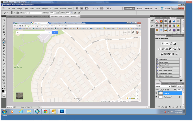
2.      Press the Alt+Prt Scr buttons on the keyboard to get a screen shot (or use your favorite screen shot software).

Google1.png
3.      Open Photshop and create a new project (on the menu use File -> New or press Ctrl+N).
4.      Paste the screenshot into the Photoshop project (on the menu use Edit -> Paste or Ctrl+V).


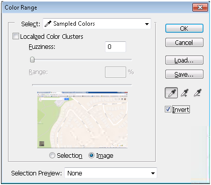
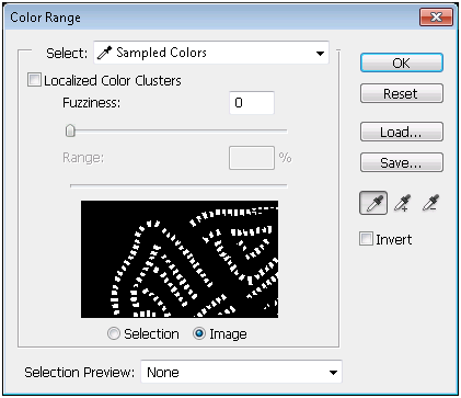
5.      From the Menu choose Select -> Color Range… (I added a custom keyboard shortcut of Alt+Shift+Ctrl+R)
6.      With the Select option set to Sampled Color click the eyedropper cursor on the center of a building.  Check the inverse option.  Press the OK button.


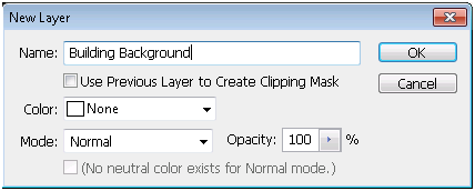
7.      With the selection still active create a new layer (on the menu use Layer -> New -> Layer… or press Shift+Ctrl+N).  Name the layer Building Background and press the OK button.


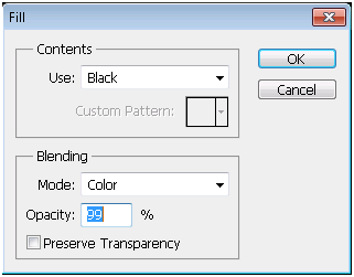
8.      Add a fill to the layer (from the menu use Edit -> Fill… or press Shift+F5). Choose the Mode “Black” and press the OK button.


9.      Deselect everything by pressing Ctrl+D.  From the menu choose Select -> Color Range... (I added a custom keyboard shortcut of Alt+Shift+Ctrl+R).  With the Select option set to Sampled Color click the eyedropper cursor on the center of a building.  Press the OK button.


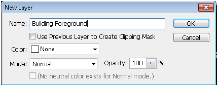
10.  With the selection still active create a new layer (on the menu use Layer -> New -> Layer… or press Shift+Ctrl+N).  Name the layer Building Foreground and press the OK button.


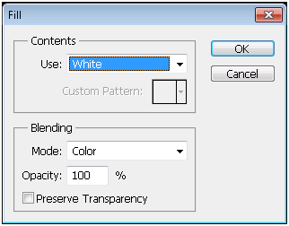
11.  Add a fill to the layer (from the menu use Edit -> Fill… or press Shift+F5). Choose the Mode “White” and press the OK button.


12.  You should now have a Black and White image.  The outlines of the roads will have areas with white pixels that need to be painted out.  Set the palette color to Black.  Right click on the map and choose a paint brush size that fits comfortably within the roadway (about 40 pixels).  Paint out the small white pixels.  Also paint out partial buildings on the edges of the map.
13.  On the menu choose Image -> Mode -> Grayscale… (I added a custom keyboard shortcut to the Grayscale option of Alt+Shift+Ctrl+G) and then choose to not Flatten the image and to Discard the Color information.


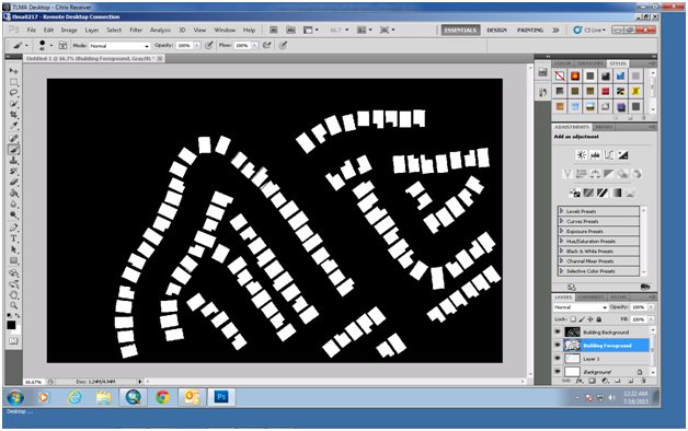
14.  Save the photoshop project as a BMP.  Use 8 Bit depth (if it says higher depths you have a problem).
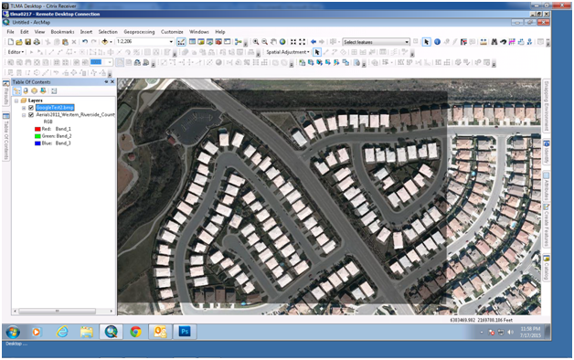
15.  Open a new ArcMap session and just add aerials or a satellite basemap.
16.  Right click the Date Frame and chose Date Frame Properties.  On the Freme tab choose the background to be black.
17.  Locate the same set of buildings on the aerial.
18.  Add the BMP you saved in step 14.  Say OK to the warning about the image not being spatially referenced.
19.  Change the BMP layer transparency to 50%.
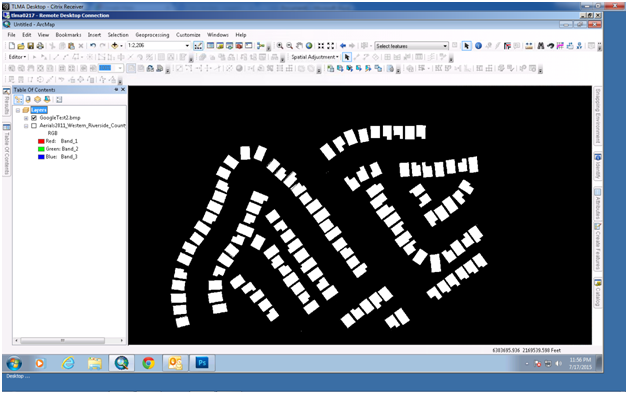
20.  Right click the BMP layer and Zoom to Layer.
21.  Open the Georeferencing toolbar.


22.  Press the Add Control Points button and choose a corner of a building that you can match to the aerial.


23.  Press the Back button to return to the aerial and set the control point at the corner of the same building on the aerial.
24.  Set another control point that is vertical or horizontal to the previous point, not diagonal.
25.  Set additional control points if necessary, but not more than 4 total points.
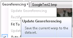
26.  When you are satisfied with the georeferencing position on the toolbar choose Georeferencing -> Update Georeferencing.


27.  Set the BMP transparency to 0% and turn off the aerials.


28.  Open the Toolboxes -> System Toolboxes -> Conversion Tools Toolbox -> From Raster Toolset -> Raster to Polygon tool.
29.  Choose the bmp as the input and set the output location and name to a geodatabase feature class and press OK.
30.  Start an editor session on the polygon layer you just created and delete the background polygon.
31.  Open the Table View for the new polygon feature class and sort by shape area. Choose any very small polygons that are not buildings that you did not paint out and delete them.

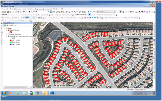
32.  Set up a permanent feature class that you will append all new buildings to or append this set of buildings to the feature class you set up previously.  The result shown below created 115 building outline polygons (the polygons are set to hollow with a red outline that is 3 points thick).

more
4 3 12.3K
TimothyHales
Esri Notable Contributor

Is ArcGIS 10.2 crashing when attempting to add shapefiles to ArcMap? We see your error reports coming in and we want you to know there’s a fix! For more details about this issue, please see this blog.

This reminder comes from Kirsten Pinkston in Esri Technical Support.

Experiencing this issue? Here’s what you need to do:

Install the patch

For those of you running ArcGIS 10.2 and experiencing crashes when working with shapefiles, it is necessary that you download and install this patch or upgrade to 10.2.1 to apply the fix.

Can’t install the patch or upgrade?

Shapefiles typically associated with this crash contain dBase files with a large number of fields. Converting these shapefiles to file geodatabase feature classes can help to work around the crashing.

Please continue to contact Esri

For any and all error reports you receive, please send them to Esri with a valid email address, as this enables us to identify and respond faster to issues impacting your work.

more
0 0 1,871
85 Subscribers