- Home
- :
- All Communities
- :
- User Groups
- :
- Local Government Solutions Users
- :
- Questions
- :
- Re: Public Notification app - buffer question
- Subscribe to RSS Feed
- Mark Topic as New
- Mark Topic as Read
- Float this Topic for Current User
- Bookmark
- Subscribe
- Mute
- Printer Friendly Page
Public Notification app - buffer question
- Mark as New
- Bookmark
- Subscribe
- Mute
- Subscribe to RSS Feed
- Permalink
Beginning work on this app -
Have a question from the main users regarding buffering. We (a City gov't) have a requirement relating to who gets notified of certain upcoming projects that results in using a 300 ft buffer most of the time. However, this is tricky because we are required to essentially not count the public right-of-way (essentially streets) in the buffer. So we need to buffer tool needs be 'smart' enough to not count the distance anytime it covers a right of way, and then continue calculating the distance after skipping over the right of way.
A giant pain, and I doubt that a simple buffer tool can be configured to do this. Anyone know if 1) the default configuration accounts for this, and 2) if not, if this kind of thing is possible?
Thanks -
Allen
- Mark as New
- Bookmark
- Subscribe
- Mute
- Subscribe to RSS Feed
- Permalink
I guess there is no way to split or intersect your buffer? Do you have a visual sample? Since you say ROW could be roads, as polylines or polygon?
- Mark as New
- Bookmark
- Subscribe
- Mute
- Subscribe to RSS Feed
- Permalink
ROW would need to be polygons, but we unfortunately don't have that data. If we did - is it possible to generate a buffer that does the kind of splitting you mention?
- Mark as New
- Bookmark
- Subscribe
- Mute
- Subscribe to RSS Feed
- Permalink
that's why I was asking if you had a visual, I was wondering whether the zones were running parallel to the roads or normal to them. I normal too them, I could see splitting them with a 'buffer' of the road (several ways ... not just conventional buffer), effectively chopping of the buffer.
The other way would be simply to do a intersection of the ROW polygons and the road intersections. This would give you a count of the places where roads cross the polygons... assuming that you want to exclude 300' as being public around the road, then your buffer would have been over-subscribed by 4 * 300' (ie left & right side of the road... left and right side of the buffer).
But a visual would help, it I am totally off
- Mark as New
- Bookmark
- Subscribe
- Mute
- Subscribe to RSS Feed
- Permalink
Thanks for taking the time to look into this Dan -
Here's a diagram from someone who would be using this app - hopefully it explains things. Basicallly as the buffer is moving outwards, when it encounters the ROW it should stop counting that distance, then resume once it crosses the ROW.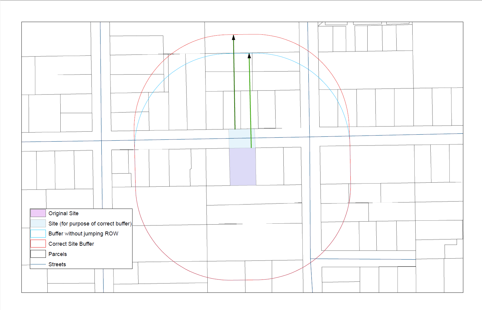
- Mark as New
- Bookmark
- Subscribe
- Mute
- Subscribe to RSS Feed
- Permalink
OK... now I see it... look along the road just north of your purple polygon and identified by the light blue area.
As the light blue area's E & W side seems to represent the length that you want to subtract from the original perimeter. It appears that you have used a buffer centered on the original site... just for fun...
- replicate the shape and move it downward by the height of the light blue area...
- buffer that
- split the buffer (assuming a polyline) using the road and calculate the northern portions length
- compare that to the original buffer, split by the road with 2*the width of the road
Just a hunch but I am on an iThing and therefore Arc*-less