- Home
- :
- All Communities
- :
- Developers
- :
- Native Maps SDKs
- :
- Java Maps SDK Questions
- :
- Re: Creating tpk file
- Subscribe to RSS Feed
- Mark Topic as New
- Mark Topic as Read
- Float this Topic for Current User
- Bookmark
- Subscribe
- Mute
- Printer Friendly Page
- Mark as New
- Bookmark
- Subscribe
- Mute
- Subscribe to RSS Feed
- Permalink
Hi,
I would like to include a local tile cache (tpk-file) into a Java App because I want to have an offline mode.
I tried to download a small area from http://www.arcgis.com/home/item.html?id=e384f5aa4eb1433c92afff09500b073d with ArcMap 10.3 but I get an error : 00005 : Layer type is not supported.
Anyone has solved this problem ?
Thanks,
Jimmy
Solved! Go to Solution.
- Mark as New
- Bookmark
- Subscribe
- Mute
- Subscribe to RSS Feed
- Permalink
Hi Colin,
Open ArcMap (new blank document) and drag/drop tpk to the map window. ArcMap should automatically be zoomed to the extent of tpk. If it does not work, please answer the two following questions:
1) What is the size of downloaded tpk?
2) What is the area (coordinates) of the data you downloaded?
Regards,
Adam
- Mark as New
- Bookmark
- Subscribe
- Mute
- Subscribe to RSS Feed
- Permalink
Thank you for the reply,
Nothing is displayed when the package is drag and dropped into ArcMap. I have tried using different extents to see if that was the problem and still nothing shows up. The area I am trying to capture is quite small; the size of a small city.
The size has been consistently coming out around 2 Mb, which I think is quite strange to begin with.
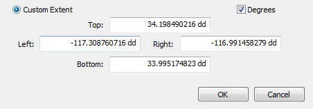
Here is the extent I am trying to capture:
Note: I recently tried with a slightly larger extent and download a much bigger file (808 Mb) but still nothing displays when loaded into ArcMap.
Thanks again for your help!
- Mark as New
- Bookmark
- Subscribe
- Mute
- Subscribe to RSS Feed
- Permalink
HI Colin,
I recreated your tpk request. The REST API request page looks like:
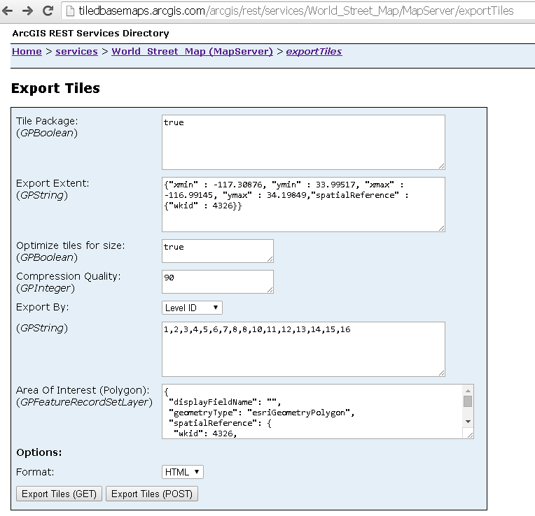
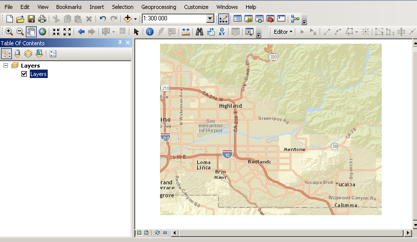
The resulting tpk is 34.6MB large. I added the file to ArcMap, and I could display it at all scales:
Please, check your request parameters first. There must be something wrong there.
Regards,
Adam
- Mark as New
- Bookmark
- Subscribe
- Mute
- Subscribe to RSS Feed
- Permalink
Thanks Adam, I got it to work finally.
For the record, I was using Imagery and not world street map. I cannot figure out why it was not working before...but it works now!
Thanks again,
Colin
- Mark as New
- Bookmark
- Subscribe
- Mute
- Subscribe to RSS Feed
- Permalink
how to get tpk file of desired latlons ?
- Mark as New
- Bookmark
- Subscribe
- Mute
- Subscribe to RSS Feed
- Permalink
This might be better in a new question by itself as this question is marked as resolved.
- Mark as New
- Bookmark
- Subscribe
- Mute
- Subscribe to RSS Feed
- Permalink
I have posted it as new question plz answer it
- « Previous
-
- 1
- 2
- Next »
- « Previous
-
- 1
- 2
- Next »