- Home
- :
- All Communities
- :
- Products
- :
- Oriented Imagery
- :
- Oriented Imagery Classic
- :
- Re: How to add aerial oblique imagery to oriented ...
- Subscribe to RSS Feed
- Mark Topic as New
- Mark Topic as Read
- Float this Topic for Current User
- Bookmark
- Subscribe
- Mute
- Printer Friendly Page
How to add aerial oblique imagery to oriented imagery catalog?
- Mark as New
- Bookmark
- Subscribe
- Mute
- Subscribe to RSS Feed
- Permalink
- Report Inappropriate Content
Hi all,
I've been trying to add oblique imagery mosaic service to an Oriented Imagery Catalog ("Add Images to Oriented Imagery Catalog"), but I keep getting an error messages stating that:
"Error in adding images from image service. 'spatialReference'"

The coordinate system for the image service is "LKS 1994 Lithuania TM" (3346). I've tried creating a mosaic with "WGS 1984 Web Mercator (3857)", but got the same error.
I've found a sample oblique service:
https://sampleserver6.arcgisonline.com/arcgis/rest/services/Oblique/WU_Oblique/ImageServer
which worked. It uses WGS 1984 Web Mercator (3857). Not sure what's wrong with my service...
Does anyone have any ideas what could be wrong here?
Thanks,
Tadas
- Mark as New
- Bookmark
- Subscribe
- Mute
- Subscribe to RSS Feed
- Permalink
- Report Inappropriate Content
Hi Tadas,
My apologies that you are facing this issue. I would like to ask you a couple of questions tho,
1. How did you create the Image Service (or mosaic dataset)? What was the raster type?
2. If you don t know the answer to the first question can you check the following URL for your Image Service.
https://<YourServerName>/arcgis/rest/services/<YourServiceName>/ImageServer/1/info/ics
This is assuming you have an object id 1. You can replace 1 with any object id.
This is a working example with NO ICS defined.
Oblique/WU_Ortho (ImageServer)
This is a working example of ICS defined.
Oblique/WU_Oblique (ImageServer)
You can check this json against the one in your service. The program is look for spatialReference in xf_1.
We have are currently addressing issues with ImageServices type and will be releasing updates to this type in the next version.
Regards,
Randall
- Mark as New
- Bookmark
- Subscribe
- Mute
- Subscribe to RSS Feed
- Permalink
- Report Inappropriate Content
Hi Randal,
Thank you for taking the time to respond!
I have created the mosaic using frame and camera tables. It does have ICS defined:
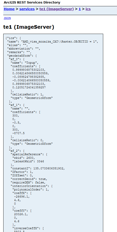
However, in the service that I have, xf_2 defines the spatialReference, while xf_1 is something else. Not sure why this difference exists. Is there a workaround?
By the way, this mosaic works fine with Oblique Viewer widget in Enterprise.
Thanks,
Tadas
- Mark as New
- Bookmark
- Subscribe
- Mute
- Subscribe to RSS Feed
- Permalink
- Report Inappropriate Content
Hi Tadas,
There is no work around available short of editing the code. Since this is a python based tool I can tell you where you can make the edit and it will work for you.
Follow these steps to make it work for you.
1. Locate this file. c:\Image_Mgmt_Workflows\OrientedImagery\Types\ImageService.py
2. Keep a backup of this file and open in a text editor.
3. Search for xf_1 and replace with xf_2. Make sure you keep the it is of lower case like in the ICS data.
4. Save the script.
5. Restart ArcGIS Pro.
We are working on a fix where the program will automatically detect which xform will have the spatial reference info.
Sorry for the inconvenience.
If you have any other issues regarding this or any other aspect of the oriented imagery GPTool do not hesitate to get in touch.
Thanks
Randall
- Mark as New
- Bookmark
- Subscribe
- Mute
- Subscribe to RSS Feed
- Permalink
- Report Inappropriate Content
Hi Randall,
Changing the script worked!
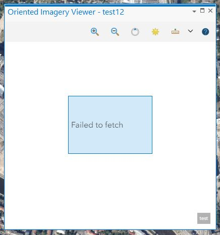
I was able to create the catalog, coverage features, coverage map and publish the catalog without any issues. However, when I add the catalog and select a location I get an error message "Failed to fetch" in ArcGIS Pro:
When I do the same in the sample Web App, I don't get any errors, but I only see a small sliver of the imagery:
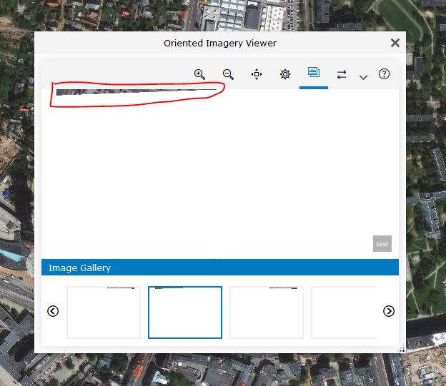
Most of the imagery is blank. Any ideas what could be the problem?
Thank you,
Tadas
- Mark as New
- Bookmark
- Subscribe
- Mute
- Subscribe to RSS Feed
- Permalink
- Report Inappropriate Content
HI Tadas,
WOuld it be possible for me to access your imagery service?
You can send me a reply directly to rrebello at esri dot com
If not.. then some screenshots of the attribute table of the OIC or any other info you can share.
Thanks,
Randall