- Home
- :
- All Communities
- :
- Industries
- :
- Imagery and Remote Sensing (I&RS)
- :
- I&RS Questions
- :
- Stereo Imagery - AT Project Format
- Subscribe to RSS Feed
- Mark Topic as New
- Mark Topic as Read
- Float this Topic for Current User
- Bookmark
- Subscribe
- Mute
- Printer Friendly Page
- Mark as New
- Bookmark
- Subscribe
- Mute
- Subscribe to RSS Feed
- Permalink
I hope someone can offer me some guidance regarding stereo imagery in ArcGIS Pro. I am currently acquiring orthophotography of my county and after having seen an article about stereo mapping using Image Analyst, I asked the vendor if they could provide the aerial imagery formatted as stereo pairs. They are able to do that, but have asked me in which format I would like the ATed image frames. They can provide;
- PAT-B
- SummitEV
- SSK/Intergraph
- Inpho
I have no experience in this area, and having checked the documentation, have not found any answers. Can someone with some experience offer some help? The vendor indicated that they most commonly use PAT-B. Will that work with Image Analyst?
Thanks,
Bruce
Solved! Go to Solution.
Accepted Solutions
- Mark as New
- Bookmark
- Subscribe
- Mute
- Subscribe to RSS Feed
- Permalink
Optimum is if you have a Aerial Triangulation project file that provides, the interior and exterior orientation parameters as well as the camera calibration. PAT-B format only provides the exterior orientation. ArcGIS has a Raster type specifically for Match-AT (Inpho) and ISAT (SSK/Intergraph). I would recommend going with the Match-AT/Info option if your vendor provides. Then you only need to create a mosaic dataset and use the Match-AT raster type. You will probably need to do a search/replace on the filenames in the provided .prj file. Also consider optimizing the format of the imagery by using say OptimizeRasters (output as TIF) to ensure best performance.
- Mark as New
- Bookmark
- Subscribe
- Mute
- Subscribe to RSS Feed
- Permalink
Thanks very much Peter. Exactly the information I needed.
- Mark as New
- Bookmark
- Subscribe
- Mute
- Subscribe to RSS Feed
- Permalink
Hi!
I'm trying to do stereo models with "ortho mapping workspace" workflow.
I have the Match-AT (inpho) project file and my overlapped images.
I put in my project file in the project file field but what is the camera file? Do i have to create one or do i need to ask my provider for it?
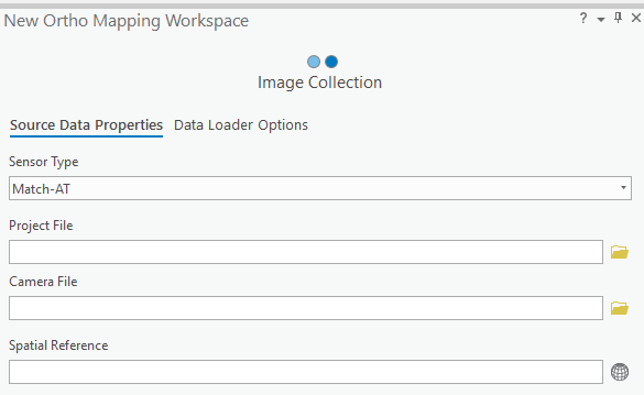
Regards Mattias
- Mark as New
- Bookmark
- Subscribe
- Mute
- Subscribe to RSS Feed
- Permalink
Mattias,
Match-AT, older Versions, have CAMERA files with them - my data in same Folder as *.prj file ... in newer versions (5+) camera information seems to be included in the prj file.
if you have Match-AT files, you would not need to start your workflow in the OrthoMapping part (your screenshot) ... you could just create a MosaicDataset, add your data using the Raster Type "Match-AT" (and ideally specifying a DEM with it) - see this description Match-AT workflows: https://pro.arcgis.com/en/pro-app/help/data/imagery/aerial-imagery-raster-types.htm#GUID-C17727AB-D9...... then you could enter the OrthoMapping Workflow with the " Import and use existing image collection" check box on the first screen.
BTW: Make sure that the paths to the images in your Match-AT project file are correct!
Regards
Guenter
- Mark as New
- Bookmark
- Subscribe
- Mute
- Subscribe to RSS Feed
- Permalink
Just to add. Note the DEM if provided just provides a better base. It is not needed to see stereo. If you provide the DTM (or constant elevation) then when you open the mosaic dataset and zoom in you should be able to see the imagery rectified to the ground in approx the correct location. This is a good way to ensure the coordinate system etc is correct. Also you do not need to use the OrthoMapping workflow. Just use the Build Stereo Model Tool. This is required to define the stereo models. In it you can also define parameters so as to limit the stereo models to only the forward overlap if required. Once the stereomodel table is created you can open the mosaic dataset in the stereo tool and the stereo models will become accessible.
- Mark as New
- Bookmark
- Subscribe
- Mute
- Subscribe to RSS Feed
- Permalink
Thanks for all the help. It now works perfectly 
Regards Mattias
- Mark as New
- Bookmark
- Subscribe
- Mute
- Subscribe to RSS Feed
- Permalink
Question for all of you, i have stereoscopic aerial photographs from 1938. Any recommendations on where i can scan them. I'm located in Southern California. Thanks.
- Mark as New
- Bookmark
- Subscribe
- Mute
- Subscribe to RSS Feed
- Permalink
Hi Mattias,
Is it possible to give me a short summary about your worflow to import a stereo-model of Match-AT (Inpho)?
Thanks, Abiy
- Mark as New
- Bookmark
- Subscribe
- Mute
- Subscribe to RSS Feed
- Permalink
Hola a todos. Necesito crear el dataset de raster para realizar una fotointerpretación con el Stereo, pero no sé cómo hacerlo. Podrían ayudarme?