- Home
- :
- All Communities
- :
- Industries
- :
- Imagery and Remote Sensing Insights (IRIS) COP
- :
- Imagery Questions
- :
- Raster does not display when zoomed in beyond a ce...
- Subscribe to RSS Feed
- Mark Topic as New
- Mark Topic as Read
- Float this Topic for Current User
- Bookmark
- Subscribe
- Mute
- Printer Friendly Page
Raster does not display when zoomed in beyond a certain scale in a Mosaic Dataset
- Mark as New
- Bookmark
- Subscribe
- Mute
- Subscribe to RSS Feed
- Permalink
- Report Inappropriate Content
I am having a problem viewing raster images in a Mosaic Dataset I created
when I zoom in beyond a certain scale. After I zoom in past 1:3,462 ft., the
image turns black. I have created other Mosaic Datasets of
ortho-imagery before with success, but these rasters seem to behave
differently. These are 1 band, black and white TIFFs with a single bit
pixel depth that represent scanned base maps. (They were already geo-referenced
by a previous firm and display correctly in our old GIS). Properties lists the
format as AMD, the SourceType as Generic, the PixelType as unsigned integer,
the Pixel Depth as 1 bit, and NoData Value is blank.
When I created the Mosaic Dataset I selected Create Overlays, Statistics,
and Pyramids and I used “NearestNeighbors”. I did not input any values for
Pyramids but left the optional fields as 0 or blank so that ArcMap would
calculate the values for me. The imagery displays fine when zoomed out.
I have cleared the visible scale range.
I have checked that the TIFF displays properly when zoomed-in using Windows
Picture viewer.
I originally created the Mosaic from the set of TIFFs that were on my local
hard drive. Everything worked except the zoom. The paths to the source rasters
were intact when I exported the path list.
I then copied the TIFFs to a subfolder on the same instance of our server
that contains our SDE database and the Mosaic Dataset. I repaired the
paths so they would point to the server copy. This worked as expected but did
not fix the zoom (no change).
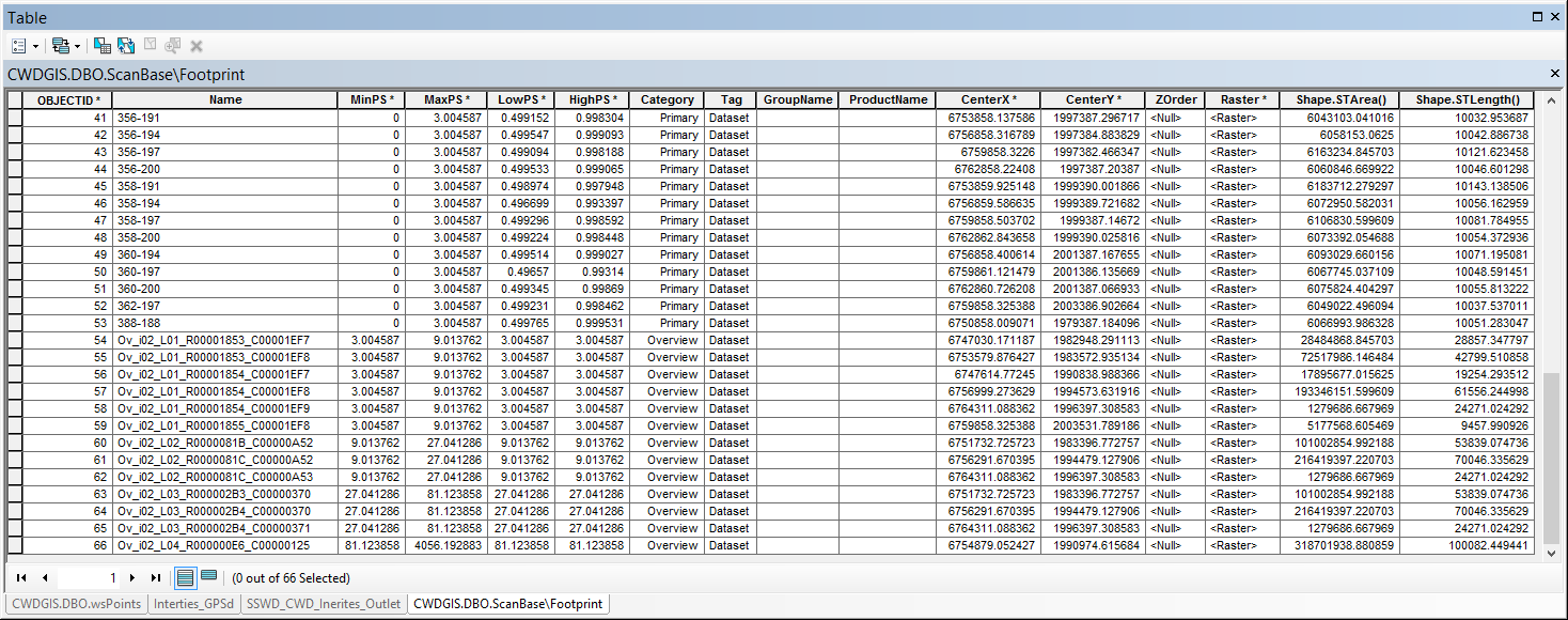
I then looked into the cell level values in the attribute table. For the
Primary rasters the MinPS was 0, the MaxPS was 3.004587, the LowPS was just
less than .5 and the HighPS was just less the 1. The first level Overviews
picked right up where the Primarys left off with a Min, Low and HighPS of 3.004587
and a MaxPS of around 9. These values incremented as expected into the 2nd
through 4th level Overviews. For reference I’ve attached a
screenshot of the table.
To double-check, I added the rasters to the Mosaic Dataset again from their
new location on the server in order to re-calculate the pyramids, overwriting duplicates.
This worked as expected but still displays exactly the same with no change.
I am wondering if this has to do with read access issues. I found a
reference to UNC paths by Jake Skinner in a thread regarding how to create
Mosaic Datasets: “When you zoom into a large enough scale,
the overviews are no longer used, the raw imagery is. Also, it is best to
load your rasters into the mosaic dataset using UNC paths (i.e.
\\servername\rasters). That way ArcGIS Server and other client machines
can access the images when zooming into a large scale.”
I’m not sure what this is distinguishing;
my pathname is \\cwdgis01\mapping\pictures\ScanBase.
The “\pictures” folder path works as it is where I store attachments for pop-up
windows.
Thanks in advance for your help!
_joe
Solved! Go to Solution.
- Mark as New
- Bookmark
- Subscribe
- Mute
- Subscribe to RSS Feed
- Permalink
- Report Inappropriate Content
Thanks for researching that, Cody. As that was an optional setting and I am new to creating Mosaic Datasets, I probably left it blank instead of choosing 1-bit. Let me try it again from scratch.
As to your other concern (and mine): I am currently the only GIS specialist for our District and the only one using ArcDesktop, so I can abide some degree of added setup parameters. I am setting up web maps through Portal for our other staff in the office and the field to view and perform basic edits and analysis, export tables, print maps, etc. These need to work easily right from their web browser and/or app.
Hopefully re-creating the MD with 1-bit specified is the fix. Our Portal web maps are not quite published yet, so I won't be able to test their functionality until our consultant finishes. Do you anticipate any problems when viewing or printing this in a web map, particularly zoomed in tight?
I will report back...
- Mark as New
- Bookmark
- Subscribe
- Mute
- Subscribe to RSS Feed
- Permalink
- Report Inappropriate Content
Hmmm, no change.
I did as you said and selected 1-bit pixel depth. I also entered "1" in the # of bands above. Otherwise, all settings were as I mentioned earlier.
In the Properties, the raster is still listed as 1-band, 1-bit, but the statistics for the band are still values 0-255.
I did copy and past the UNC path from my server when I added the rasters. I selected "Workspace" as the TIFFs are all in a folder along with their world files.
Turning on DRA still allows the images to display.
- Mark as New
- Bookmark
- Subscribe
- Mute
- Subscribe to RSS Feed
- Permalink
- Report Inappropriate Content
Cody (and anyone else interested),
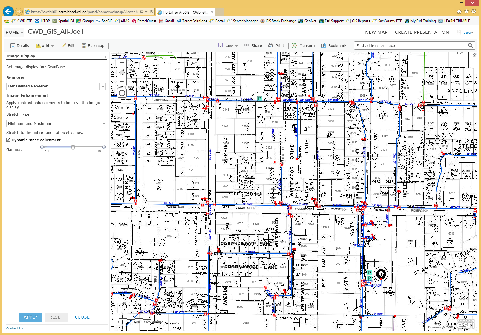
Now that our Portal is up, I tested this Mosaic in our WebMap. It behaved the same way, turning black when zoomed in past 1"=200ft. Luckily, I figured out how to do the same DRA in the Web Map:
After publishing the 1-bit Mosaic and adding it to the map I am building, I selected the "Image Display" from the pull down menu for my Mosaic layer. I left the "Renderer" as user defined (only used for multi-band rasters), but selected "Minimum and Maximum" as the Stretch Type. This allowed me to select "Dynamic Range Adjustment", which brought the imagery back up without even having to adjust the gamma from 1.0.
I'm still not sure if this is a good long term solution as I have not tested it in the field. But I'm hopeful!
- Mark as New
- Bookmark
- Subscribe
- Mute
- Subscribe to RSS Feed
- Permalink
- Report Inappropriate Content
Cody,
I have recently experienced the same phenomena for a number of existing Mosaic Data Sets (MDS) that are sources for Image services. Observed after two actions in our ArcGIS Enterprise environment (1) a move of the source rasters from one storage location to another and (2) an upgrade of ArcGIS Enterprise from 10.4.1 to 10.8.1. The source raster move was compared for differences by my Enterprise storage team. The folder/file structure, number of files and file sizes match. Another variable is the original MDS were created in ArcGIS Desktop (ArcCatalog/ArcMap from version 10.4.1 to 10.6.1), I am now managing all of our MDS in ArcGIS Pro version 2.6.
These source rasters are 4 band RGBI .tif 8 bit unsigned.
I have tried most everything including complete deletion of overviews and re-generation after compacting the File GeoDataBase (FGDB) containing the MDS(s). Unsolved. Ideas please?
Sincerely,
Todd Metzler
ArcGIS Enterprise Administrator
- Mark as New
- Bookmark
- Subscribe
- Mute
- Subscribe to RSS Feed
- Permalink
- Report Inappropriate Content
I have a similar problem with Pro 2.4 except when I zoom in too far into the mosaic I get the black & white chess board pattern, which is doubly strange as the map background is set to blue. No zoom display restrictions I can find anywhere, no idea why it does this. Toggling the DRA option makes no difference, changing around the stretch type also doesn't seem to change it.
- Mark as New
- Bookmark
- Subscribe
- Mute
- Subscribe to RSS Feed
- Permalink
- Report Inappropriate Content
My son would agree that is a chess board  but this doc explains why we display the black & white checkerboard as a visual warning.
Problem: Mosaic datasets display a checkerboard pattern when viewed from a different machine
When zoomed out, you are seeing overviews, but when you zoom in, the system is not able to access the full resolution images for one of several possible reasons - perhaps they've moved, or the files or path have been renamed, or you're hitting a permission error...
- Mark as New
- Bookmark
- Subscribe
- Mute
- Subscribe to RSS Feed
- Permalink
- Report Inappropriate Content
The permissions & locations are ok, so it appears I can't do anything at all with mosaic datasets anymore now that I've only got Pro with just the basic license. Any work around ideas?
- « Previous
-
- 1
- 2
- Next »
- « Previous
-
- 1
- 2
- Next »