- Home
- :
- All Communities
- :
- Industries
- :
- Imagery and Remote Sensing Insights (IRIS) COP
- :
- Imagery Questions
- :
- "Failed to save raster dataset"
- Subscribe to RSS Feed
- Mark Topic as New
- Mark Topic as Read
- Float this Topic for Current User
- Bookmark
- Subscribe
- Mute
- Printer Friendly Page
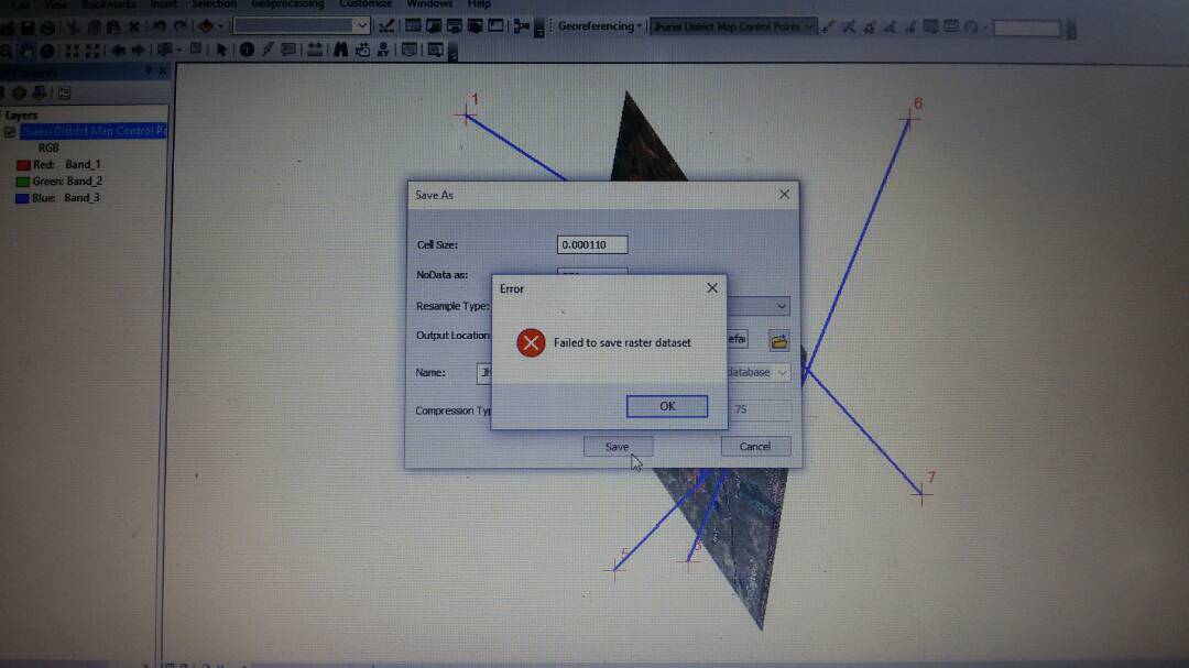
"Failed to save raster dataset"
- Mark as New
- Bookmark
- Subscribe
- Mute
- Subscribe to RSS Feed
- Permalink
- Report Inappropriate Content
- Mark as New
- Bookmark
- Subscribe
- Mute
- Subscribe to RSS Feed
- Permalink
- Report Inappropriate Content
There are lots of reasons this could happen -- invalid pathname, not enough space on disk ...
The screen shot seems to suggest that you are trying to georeference a raster and that your control points are producing a very inadequate (high-error) transformation. The image looks terribly distorted.
- Mark as New
- Bookmark
- Subscribe
- Mute
- Subscribe to RSS Feed
- Permalink
- Report Inappropriate Content
Thanks Curtis, i will retry with more adequate control points,
i appreciate your help...
Regards,
Shahid Raza
- Mark as New
- Bookmark
- Subscribe
- Mute
- Subscribe to RSS Feed
- Permalink
- Report Inappropriate Content
make sure they are spread about the image... if your control points are closely clustered, there is no way that you will ever get an acceptable result.
- Mark as New
- Bookmark
- Subscribe
- Mute
- Subscribe to RSS Feed
- Permalink
- Report Inappropriate Content
Ok, I will keep it in Mind, Thanks Dan...
Best Regards,
Shahid Raza
- Mark as New
- Bookmark
- Subscribe
- Mute
- Subscribe to RSS Feed
- Permalink
- Report Inappropriate Content
I've had the same non-descriptive error message. If you try to name your raster starting with a number, you'll also get his error. For example, I first tried naming a raster that I georeferenced 2019-01-08_AreaName. Then I tried again with AreaName20190108, and it's rectifying as expected. I hope this helps.
- Mark as New
- Bookmark
- Subscribe
- Mute
- Subscribe to RSS Feed
- Permalink
- Report Inappropriate Content
do note that AreaName20190108 wouldn't work if the output raster was an esri grid since the name is too long, but it would work for a *.tif
- Mark as New
- Bookmark
- Subscribe
- Mute
- Subscribe to RSS Feed
- Permalink
- Report Inappropriate Content
A quick and dirty solution is to do an export>export data from the table of contents. The exported GeoTiff will retain the transformations you inputted with the georeferencing tools.
- Mark as New
- Bookmark
- Subscribe
- Mute
- Subscribe to RSS Feed
- Permalink
- Report Inappropriate Content
HOW can i rectify it now???/
- Mark as New
- Bookmark
- Subscribe
- Mute
- Subscribe to RSS Feed
- Permalink
- Report Inappropriate Content
I had the same problem as you, and I rebuilt the pyramid. 我遇到了和你一样的问题,重新建造了金字塔就可以了。