- Home
- :
- All Communities
- :
- Products
- :
- Imagery and Remote Sensing
- :
- Imagery Questions
- :
- Re: I'm using Arc 10 and want to know how to uploa...
- Subscribe to RSS Feed
- Mark Topic as New
- Mark Topic as Read
- Float this Topic for Current User
- Bookmark
- Subscribe
- Mute
- Printer Friendly Page
I'm using Arc 10 and want to know how to upload tiles and a dataset (polygons). Anyone still familiar with this!?
- Mark as New
- Bookmark
- Subscribe
- Mute
- Subscribe to RSS Feed
- Permalink
- Report Inappropriate Content
I'm using Arc 10 and want to know how to upload tiles and a dataset (polygons). Anyone still familiar with this!?
- Mark as New
- Bookmark
- Subscribe
- Mute
- Subscribe to RSS Feed
- Permalink
- Report Inappropriate Content
Insert a new empty dataframe don't add any other data.
Click on the Add Data Button (yellow plus)
Navigate to the folder that you unzipped the *.tif file too (all the other parts are needed)
Add just one tif file and nothing else
Does the file load?/show? If not, right-click on the file's name in the table of contents of the map and select zoom to layer Does it show now?
- Mark as New
- Bookmark
- Subscribe
- Mute
- Subscribe to RSS Feed
- Permalink
- Report Inappropriate Content
OK. I:
Opened ArcMap10
Inserted new dataframe
Added 1 x tif file - it does not appear that I can insert the constituent
parts of the folder (tif tfw aux.xml and ovr) - just the whole file
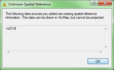
The following message comes up:
If I press OK the tile has loaded - but of course the scale is not there.
Regards,
Ben Scotting BSc (Hons) ABC Arb MCIEEM
Project ManagerRural Development Initiatives
Office: +44 (0) 1765 609 355
Mobile: +44 (0) 7957 172 021
Email: ben.scotting@ruraldevelopment.org.uk
Address: Rural Development Initiatives Ltd.
Unit 9, Sycamore Business Park,
Copt Hewick, Ripon,
North Yorkshire, HG4 5DF
Website: www.ruraldevelopment.org.uk <http://clicks.clearformat.com/mbq46>
Disclaimer
Important: This message is private and confidential. If you have received
this message in error, please notify us and remove it from your system.
Rural Development Initiatives Ltd. is a limited company registered in
Scotland. Registered number: SC278363. Registered office:The Soap Factory,
111 Gallowgate, Aberdeen, AB25 1BU. Please note that Rural Development
Initiatives Ltd. may monitor email traffic data and also the content of
email for the purposes of security and staff training. This message (and
any associated files) is intended only for the use of the recipient and may
contain information that is confidential, subject to copyright or
constitutes a trade secret. If you are not the intended recipient you are
hereby notified that any dissemination, copying or distribution of this
message, or files associated with this message, is strictly prohibited. If
you have received this message in error, please notify us immediately by
replying to the message and deleting it from your computer. Any views or
opinions presented are solely those of the author and do not necessarily
represent those of the company.
- Mark as New
- Bookmark
- Subscribe
- Mute
- Subscribe to RSS Feed
- Permalink
- Report Inappropriate Content
Maybe the tfw files (worldfiles) aren't correctly? You could open them with a editor and have a look what's written there?
You need information about the coordinate system of your raster data.
- Mark as New
- Bookmark
- Subscribe
- Mute
- Subscribe to RSS Feed
- Permalink
- Report Inappropriate Content
an image... in your case, a *.tif ... can have many parts that is why you use the Add data button, it does the figuring out of which bit(s) to use.
1 I just want to ensure that the images are good... ie they load ... so far so good
2 What 'scale' they have depends on whether they have real world coordinates or not...
If the image is just a bunch of pixels without any guidance as to the pixel width and height and some location parameter
(ie top left corner perhaps ... there are other ways
3 If you lack this information, then you have a 'picture' and you will need to get or confirm the information in step 2...
That information may be contained in the *.tfw file or other bits
When you can assemble what you have, report your findings so others can move you forward
- Mark as New
- Bookmark
- Subscribe
- Mute
- Subscribe to RSS Feed
- Permalink
- Report Inappropriate Content
If you use this data or similar:
1:250 000 Scale Colour Raster support
You could download the tfw (worldfiles) files on this page?
- Mark as New
- Bookmark
- Subscribe
- Mute
- Subscribe to RSS Feed
- Permalink
- Report Inappropriate Content
As Dan mentioned, the .tfw should contain info about the spatial reference. It needs to have the exact same base name as the tif (i.e. same, except the extension) and needs to be in the same folder and the .tif. As an example. my .tfw (in an Albers projection, so yours will look different
edit: might help to see one of your .tfw files...or if you can zip all the files for one of your images and upload, it may help others troubleshoot. Even a .zip may be too large to upload to Geonet (not sure of the limit offhand)
25.0000000000
0.0000000000
0.0000000000
-25.0000000000
-1039987.5000000000
1279987.5000000000
- Mark as New
- Bookmark
- Subscribe
- Mute
- Subscribe to RSS Feed
- Permalink
- Report Inappropriate Content
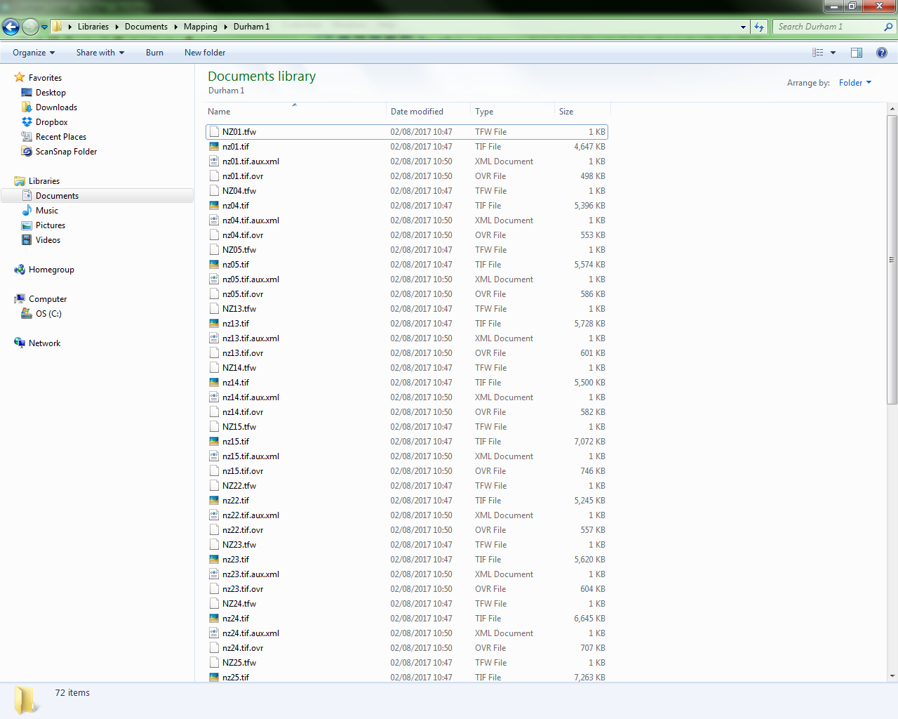
OK the file names are the same (NZ01.tfw = NZ01.tif etc). But I can't get
into the tfw files to alter them. A web search suggests Arc Reader as a
program to open thje tfw file but there doesn't appear to be a download for
ArcReader 10 (I am presuming the version has to match the GIS version (Arc
Reader 10 for ArcGIS 10 and so on).
Cheers,
Ben Scotting BSc (Hons) ABC Arb MCIEEM
Project ManagerRural Development Initiatives
Office: +44 (0) 1765 609 355
Mobile: +44 (0) 7957 172 021
Email: ben.scotting@ruraldevelopment.org.uk
Address: Rural Development Initiatives Ltd.
Unit 9, Sycamore Business Park,
Copt Hewick, Ripon,
North Yorkshire, HG4 5DF
Website: www.ruraldevelopment.org.uk <http://clicks.clearformat.com/mbq46>
Disclaimer
Important: This message is private and confidential. If you have received
this message in error, please notify us and remove it from your system.
Rural Development Initiatives Ltd. is a limited company registered in
Scotland. Registered number: SC278363. Registered office:The Soap Factory,
111 Gallowgate, Aberdeen, AB25 1BU. Please note that Rural Development
Initiatives Ltd. may monitor email traffic data and also the content of
email for the purposes of security and staff training. This message (and
any associated files) is intended only for the use of the recipient and may
contain information that is confidential, subject to copyright or
constitutes a trade secret. If you are not the intended recipient you are
hereby notified that any dissemination, copying or distribution of this
message, or files associated with this message, is strictly prohibited. If
you have received this message in error, please notify us immediately by
replying to the message and deleting it from your computer. Any views or
opinions presented are solely those of the author and do not necessarily
represent those of the company.
- Mark as New
- Bookmark
- Subscribe
- Mute
- Subscribe to RSS Feed
- Permalink
- Report Inappropriate Content
You can simply use notepad to open the wordfiles.
I think the problem is that your NZ01.tfw and nz01.tif is not the same name for the files!
You could rename NZ01.tfw to nz01.tfw and try to load nz01.tif.
- Mark as New
- Bookmark
- Subscribe
- Mute
- Subscribe to RSS Feed
- Permalink
- Report Inappropriate Content
So if I change the .tfw to .tif that will work...?!!
Ben Scotting BSc (Hons) ABC Arb MCIEEM
Project ManagerRural Development Initiatives
Office: +44 (0) 1765 609 355
Mobile: +44 (0) 7957 172 021
Email: ben.scotting@ruraldevelopment.org.uk
Address: Rural Development Initiatives Ltd.
Unit 9, Sycamore Business Park,
Copt Hewick, Ripon,
North Yorkshire, HG4 5DF
Website: www.ruraldevelopment.org.uk <http://clicks.clearformat.com/mbq46>
Disclaimer
Important: This message is private and confidential. If you have received
this message in error, please notify us and remove it from your system.
Rural Development Initiatives Ltd. is a limited company registered in
Scotland. Registered number: SC278363. Registered office:The Soap Factory,
111 Gallowgate, Aberdeen, AB25 1BU. Please note that Rural Development
Initiatives Ltd. may monitor email traffic data and also the content of
email for the purposes of security and staff training. This message (and
any associated files) is intended only for the use of the recipient and may
contain information that is confidential, subject to copyright or
constitutes a trade secret. If you are not the intended recipient you are
hereby notified that any dissemination, copying or distribution of this
message, or files associated with this message, is strictly prohibited. If
you have received this message in error, please notify us immediately by
replying to the message and deleting it from your computer. Any views or
opinions presented are solely those of the author and do not necessarily
represent those of the company.
- Mark as New
- Bookmark
- Subscribe
- Mute
- Subscribe to RSS Feed
- Permalink
- Report Inappropriate Content
You could try that ... nothing to loose 🙂