- Home
- :
- All Communities
- :
- Products
- :
- Imagery and Remote Sensing
- :
- Imagery Questions
- :
- Help with oblique imagery - setting up the Cameras...
- Subscribe to RSS Feed
- Mark Topic as New
- Mark Topic as Read
- Float this Topic for Current User
- Bookmark
- Subscribe
- Mute
- Printer Friendly Page
Help with oblique imagery - setting up the Cameras table
- Mark as New
- Bookmark
- Subscribe
- Mute
- Subscribe to RSS Feed
- Permalink
- Report Inappropriate Content
Hi,
I would like to test the Oblique viewer sample and for that I need to prepare the Mosaic Dataset and publish it. I have found some sample datasets here: https://www.sensefly.com/drones/example-datasets.html
I have tried the sample called "Oblique imagery"
I created and populated Cameras and Frames tables and created Mosaic Dataset using these tables. Rasters are loaded, but the distortion parameteres seem to be not set up properlly because Footprints looks unreal: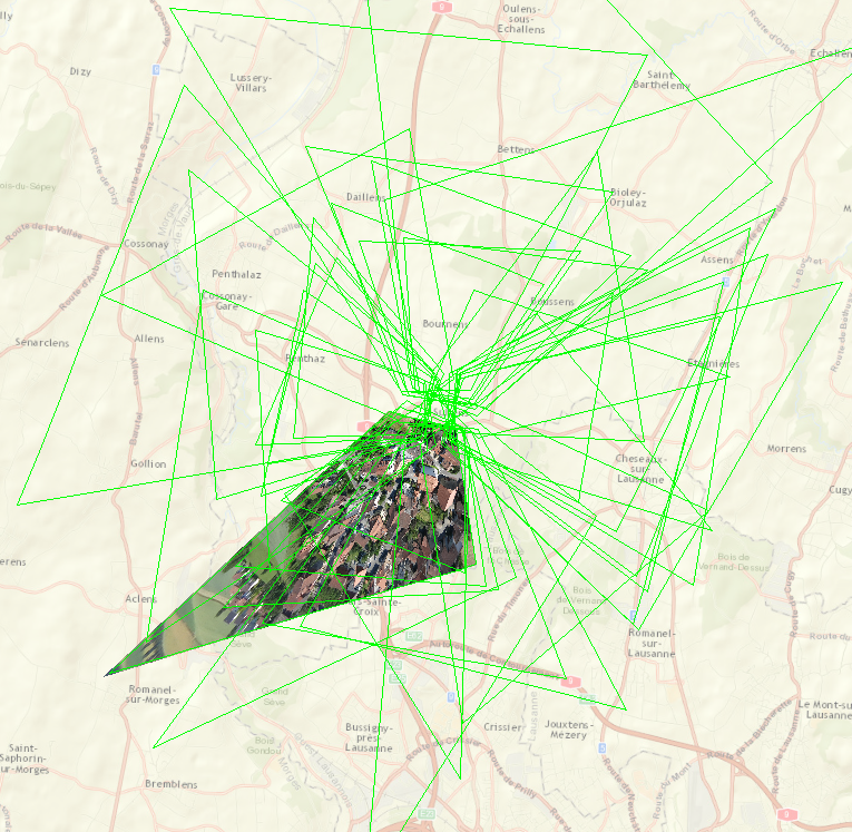
My Camera table looks like:
| OBJECTID | CAMERAID | FOCALLENGTH | PRINCIPALX | PRINCIPALY | A0 | A1 | A2 | B0 | B1 | B2 | SRS | Konrady | DistortionType |
| 1 | [0] | 5387.47722 | -66.313653 | 15.2541 | -3720.169725 | 1.86055 | 0 | 2789.894725 | 0 | -1.8605 | 32632 | 0;-0.00018232164051963605;-5.1623376542584604e-006;1.235913254591796e-007 | Esri-Konrady |
My Frames table sample is:
| OBJECTID | Omega | Phi | Kappa | SRS | CameraID | NCols | NRows | NBands | PixelType | Raster | PerspectiveX | PerspectiveY | PerspectiveZ | |
| 1 | 45.899019 | -7.362863 | 175.289717 | 32632 | [0] | 4000 | 3000 | 3 | 8_BIT_UNSIGNED | ...\IMG_7719.JPG | 313636.698978 | 5162861.933003 | 714.078282 | |
| 2 | 45.912378 | -2.495157 | 171.893432 | 32632 | [0] | 4000 | 3000 | 3 | 8_BIT_UNSIGNED | ...\IMG_7720.JPG | 313643.441509 | 5162858.355595 | 713.06864 |
Can anyone please check my values?
Thanks in advance.
Filip
- Mark as New
- Bookmark
- Subscribe
- Mute
- Subscribe to RSS Feed
- Permalink
- Report Inappropriate Content
Hi Filip
I do not know the answer to your question but I have many image services and very interest to get what you see in the screen shot.
Your link to the sample does not work but I found it any way. It does not have too much information. Can you explain what you did to get to the screen shot?
Thanks
Mody
- Mark as New
- Bookmark
- Subscribe
- Mute
- Subscribe to RSS Feed
- Permalink
- Report Inappropriate Content
Hi Mody,
the correct link is: https://www.arcgis.com/home/item.html?id=d91008d8ca85490ab423715a16d63527
Sorry for that and thank for your answer.
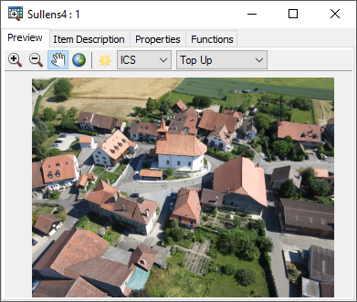
What can be seen on screenshot is a view on Mosaic dataset footprints in ArcMap with one raster loaded using Add Selected Rasters to Map function.
I did it to try viewing the image in Image Coordinate System using instructions from here: Displaying Images in an Image Coordinate System—Help | ArcGIS for Desktop
For some images, I can get the good preview in ICS (please see below), but for some not. I believe there is a problem in Camera or Frames table, that generates these unreal footprints.
I will doublecheck the values as Cody poposes.
Regards.
Filip
- Mark as New
- Bookmark
- Subscribe
- Mute
- Subscribe to RSS Feed
- Permalink
- Report Inappropriate Content
Filip
Sorry I didn't answer earlier; I am seeking to verify this with our engineers but we haven't had time to review your data in detail. It appears to me that your configuration is nearly correct, but something is scaling the values to be much too large. I posted earlier (incorrectly) that I believed the PerspectiveZ may be height above ground, but I have since verified that it should represent Orthometric height. (We are working to clarify the documentation for this table to ensure it is clear how the Z values are defined.)
I'll review in the next day or two if time permits, but please verify units for parameters in both the camera and frame tables; I know that there are some mixed units (microns and millimeters), so I expect you have a value in microns that should be mm, and that is causing the scale errors.
Cody B
- Mark as New
- Bookmark
- Subscribe
- Mute
- Subscribe to RSS Feed
- Permalink
- Report Inappropriate Content
Hi
I have checked the values in tables and they should be OK. I have only doubts about Matrix att in Frames table (please see below).
Cameras table:
FocalLength - I converted from milmeters to microns (from internal_camera_parameters.cam file)
PrincipalX - I converted from value Px in milmeters to microns (from internal_camera_parameters.cam file)
PrincipalY - I converted from Py in milmeters to microns (from internal_camera_parameters.cam file)
Coefficients A0, A1, A2, B0, B1, B2 were calculated using formulas from here:
http://proceedings.esri.com/library/userconf/devsummit16/papers/dev_int_237.pdf (page 9), or this image taken from that document:
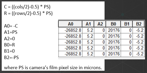
As input I used:
PixelSize [microns] 1.86055 - calculated assuming 4000x3000 image pixels image and converted from sensor width in milimeters in internal_camera_parameters.cam file
SenzorWidth [microns] 7442.2 - calculated and converted from sensor width in milimeters in internal_camera_parameters.cam file
SensorHeight [microns] 5581.65 - calculated and converted from sensor width in milimeters in internal_camera_parameters.cam file
Frames table:
PerspectiveX - values in meters (SRS = 32632)
PerspectiveY - values in meters (SRS = 32632)
PerspectiveZ - I believe that it is in WGS84 Ellipsoidical height or Orthometric height - meters
Omega - in degrees
Phi - in degrees
Kappa - degrees
NCols - in pixels = 4000
NRows - in pixels = 3000
Matrix - I have found out that I dont have this field in my table. In params folder of sample data I used is pmatrix.txt file, which contains image name and 12 floating point values. The Frames table documentation states only 9 values. Can these values be used? Or do I have to left the fourth value in every row? The documentation of pmatrix file is avilable here:
Is it Required if Camera uses OrientationType = OPK (default)??
Thanks for help. Regards.
Filip
- Mark as New
- Bookmark
- Subscribe
- Mute
- Subscribe to RSS Feed
- Permalink
- Report Inappropriate Content
Hi Cody.
Have you had a time to take look at the data sample? Thanks.
Filip
- Mark as New
- Bookmark
- Subscribe
- Mute
- Subscribe to RSS Feed
- Permalink
- Report Inappropriate Content
Hi Filip - sorry, no. I am on vacation and have not had time to look at this. I will contact one of my colleagues and ask them to respond.
Cody B.
- Mark as New
- Bookmark
- Subscribe
- Mute
- Subscribe to RSS Feed
- Permalink
- Report Inappropriate Content
Hi Cody,
hope you had a pleasant vacation. Have you or any of your colleagues time to look at the data? Thank you.
With regrads
Filip
- Mark as New
- Bookmark
- Subscribe
- Mute
- Subscribe to RSS Feed
- Permalink
- Report Inappropriate Content
Hi
How did you create the camera table and frame table? Did you use an third-party sw like pix4d to export the parameters?
Have you tried this with own drone images?
It been a while since you posted so i'm trying to do this in arcgis pro
Regards Mattias
- Mark as New
- Bookmark
- Subscribe
- Mute
- Subscribe to RSS Feed
- Permalink
- Report Inappropriate Content
Mattias
Presuming that you have interior and exterior orientation data in another format, this geoprocessing tool is designed to create the tables needed by ArcGIS Pro:
Build Frames and Cameras Tables Tool—ArcGIS Pro | Documentation
If you don't have the interior and exterior orientation data, generating that orientation data is a different challenge.
Ortho Mapping in ArcGIS Pro (Advance license) can also do this automatically as long as the oblique orientation is not too extreme (closer to nadir, not aimed at horizon), and it will directly create a mosaic dataset for you (you don't need to create the two tables).
If you don't have ArcGIS Pro Advance license Yes, Drone2Map or Pix4D can create the interior and exterior orientation data
Cody B.