- Home
- :
- All Communities
- :
- Industries
- :
- Imagery and Remote Sensing (I&RS)
- :
- I&RS Questions
- :
- File size increase when projecting raster
- Subscribe to RSS Feed
- Mark Topic as New
- Mark Topic as Read
- Float this Topic for Current User
- Bookmark
- Subscribe
- Mute
- Printer Friendly Page
- Mark as New
- Bookmark
- Subscribe
- Mute
- Subscribe to RSS Feed
- Permalink
Why when is it that when I project a raster from Alaska state plane zone 4 feet to Web Mercator does the file size increase so dramatically? It starts at ~29MB before it is projected and then increases to ~257MB after projection.
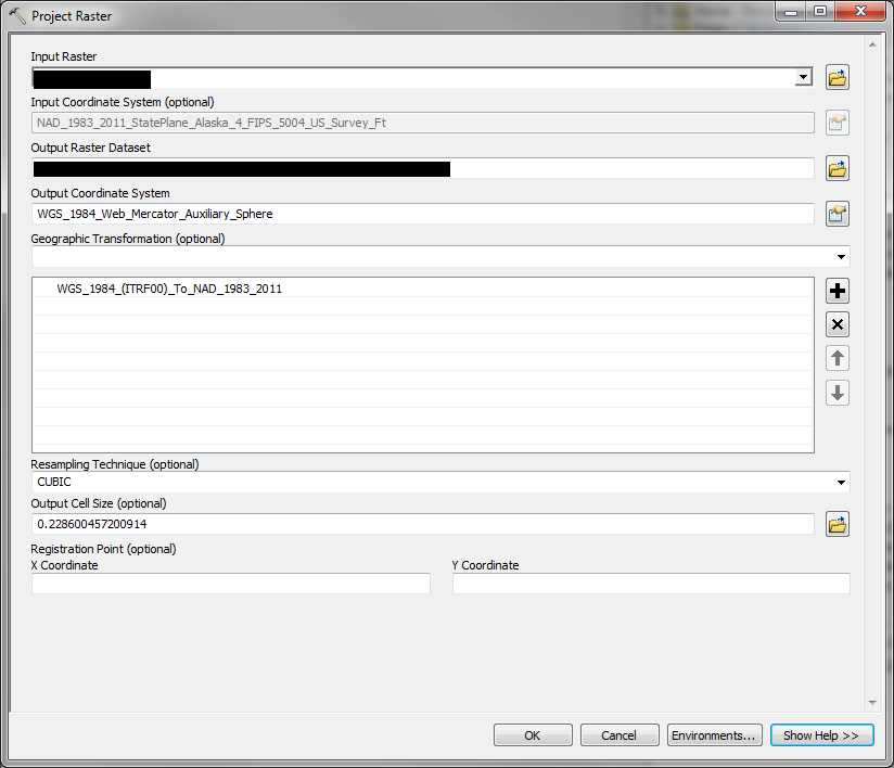
NAD_1983_2011_StatePlane_Alaska_4_FIPS_5004_US_Survey_Ft
WGS_1984_Web_Mercator_Auxiliary_Sphere
The only thing I can think of is that the distortion in web mercator at high latitudes is causing the raster to be "stretched" in some way and then leading to an increase in file size.
Thanks for any input.
Solved! Go to Solution.
- Mark as New
- Bookmark
- Subscribe
- Mute
- Subscribe to RSS Feed
- Permalink
It does feel like this is the only possibility, other then the tool just having some error that is expressing it's self in this situation. But I would think that the tool would compensate for the distortion as one moved to different areas of the projection (kinda the point of projecting). I can manually set the cell size larger, like .4m and produce cells that are still smaller then .75ft when displayed in Arc, and not have loss in image quality.
I sent a sanitized raster to Coby, the esri person on this thread, for testing. So, we will see what they say...
- Mark as New
- Bookmark
- Subscribe
- Mute
- Subscribe to RSS Feed
- Permalink
Yes, you're right - the reprojection to web mercator results in smaller cells from the conversion to meter, from foot. Sorry - should have clarified that as an observation rather than the cause.
- Mark as New
- Bookmark
- Subscribe
- Mute
- Subscribe to RSS Feed
- Permalink
Also, in the past, I have run into problems with the raster environment settings - ArcGIS Help (10.2, 10.2.1, and 10.2.2)
- Mark as New
- Bookmark
- Subscribe
- Mute
- Subscribe to RSS Feed
- Permalink
Forest,
what hat compression is being applied to the output image? Is it the same as the source. Under the Environments there is a raster storage setting called compression which specifies the compression used on the image. See the help topic
Depending in in the source compression and the resultant image you could see these size changes.
cheers
Gordon
- Mark as New
- Bookmark
- Subscribe
- Mute
- Subscribe to RSS Feed
- Permalink
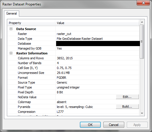
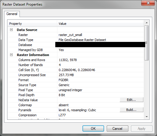
Both are LZ77
- Mark as New
- Bookmark
- Subscribe
- Mute
- Subscribe to RSS Feed
- Permalink
For LZ77, there is no appreciable difference in file size between level 5 and 6 pyramids:
http://help.arcgis.com/EN/arcgisdesktop/10.0/help/index.html#//009t00000019000000
So that shouldn't be an issue. Actually, according to the documentation, the most this should cost you is 8%.
- Mark as New
- Bookmark
- Subscribe
- Mute
- Subscribe to RSS Feed
- Permalink
Forest
There is something fundamentally wrong, but so far I can't figure out what it is. Most of the dialogue above is correct - it's not a difference in compression or units - but the number of rows and columns of your output should not be dramatically different than the input. I can't figure out why that would happen. It almost seems like you have a custom projection, and something in that projection definition is confusing the software - e.g. it automatically figures out that 0.75 feet = 0.228 meters, but then when reprojecting, it "forgets" that the units are changing, so it's outputting 9 identical pixels for every single input pixel (oversampling from 0.75 units to 0.228 units of the *same* units).
A few questions (although I do not believe that these explain the problem)
1) why are your rasters in a database? I typically recommend against that - rather, store as *.tif on disk and access them via a mosaic dataset. Is there a reason you can't do this?
2) Is there a reason that you MUST reproject and duplicate your data? If you use a mosaic dataset, you can project on the fly and not consume disk space or processing time...
3) have you reproduced this with other rasters, or is this one doi\ng something unique?
If you could send me your input file - or a smaller one that is doing the same thing - I'd like to try to reproduce it.
contact me for an upload link - [email protected]
Cody B
- Mark as New
- Bookmark
- Subscribe
- Mute
- Subscribe to RSS Feed
- Permalink
1) I just put them into gdb for the projection processing as I have run into weird and unknown problems in the past when working with the tifs (this may still not be a problem. Last time I did this we still had a mixed environment 9.3 and 10.1. Now we have almost retired all of the 9.3 stuff)
2) The data must be projected for use in web maps. In the past we had a map service of a raster dataset that reprojected on the fly, but it was fuzzy when viewed at small scales. Now maybe a image service off of a mosaic dataset would not have this problem, but I understand that we would need an image server extension for ArcGIS server. The current plan is to have a cached map service on the hard drive of server in the same projection as the web mapping application.
3) This is a problem for all of our 2015 and 2012 ortho images.
Sadly, I can not share any part of the data as it is confidential; however, I will try and find something that I can share with you that has the same behavior.
- Mark as New
- Bookmark
- Subscribe
- Mute
- Subscribe to RSS Feed
- Permalink
Forest
Got it -
[disclaimer - text here has been edited to correct a misstatement I made previously]
This may appear that Project Raster is in error but (as noted in my summary posted 10/12) it is actually honoring the definition of the Web Mercator projection which results in significant (but predictable) distortion at latitudes far from the equator.
One note, have you tried directly generating raster tile cache from the source data? I'm now concerned that you're duplicating data twice (state plane --> web mercator --> cache).
[another edit - raster tile cache is not suitable if the data is 32 bit (float) per pixel ]
If you're not aware, you can generate cache using ArcGIS Desktop. We did a recorded webinar (accessible at this link Esri Training | Sharing Cached Imagery in ArcGIS ) that explains some of the details.
Cody B.
- Mark as New
- Bookmark
- Subscribe
- Mute
- Subscribe to RSS Feed
- Permalink
Great. We don't want two data sets if we don't need them. I will review the webinar.