- Home
- :
- All Communities
- :
- Industries
- :
- Imagery and Remote Sensing Insights (IRIS) COP
- :
- Imagery Questions
- :
- Re: What is PhotoIndex and what does it for and ho...
- Subscribe to RSS Feed
- Mark Topic as New
- Mark Topic as Read
- Float this Topic for Current User
- Bookmark
- Subscribe
- Mute
- Printer Friendly Page
What is PhotoIndex and what does it for and how do I use it ?
- Mark as New
- Bookmark
- Subscribe
- Mute
- Subscribe to RSS Feed
- Permalink
This is all new to me about learning how to use Aerial Photos. I have a very old ones that that are dated back to 1938 and I am having a really hard time to identify features there. I have them that are scanned at scale of 20,000. They are most on the mountainous areas and it lacks the features that I could find them.
My question to you what is Photo Index shapefile I have here? They are point shapefile that shows the flight that took them. How can I use it ?
I plan on to using to orthorectify them through ERDAS 2016 Imagine AutoSync.. I believe I have them about at least 3,000 all over my forest here.
I am not really familiar about them very much but I have google it around online and found some good information.
https://www.asprs.org/a/publications/proceedings/Sacramento2012/files/Ma.pdf
http://depts.washington.edu/pnwcesu/reports/J8W07110015_Final_Report.pdf
Do you have a website that discuss about them or some examples that may be helpful to me or can I look at them?
- Mark as New
- Bookmark
- Subscribe
- Mute
- Subscribe to RSS Feed
- Permalink
Ok, sir I will do that and I will do my best to make it bigger picture HA HA
- Mark as New
- Bookmark
- Subscribe
- Mute
- Subscribe to RSS Feed
- Permalink
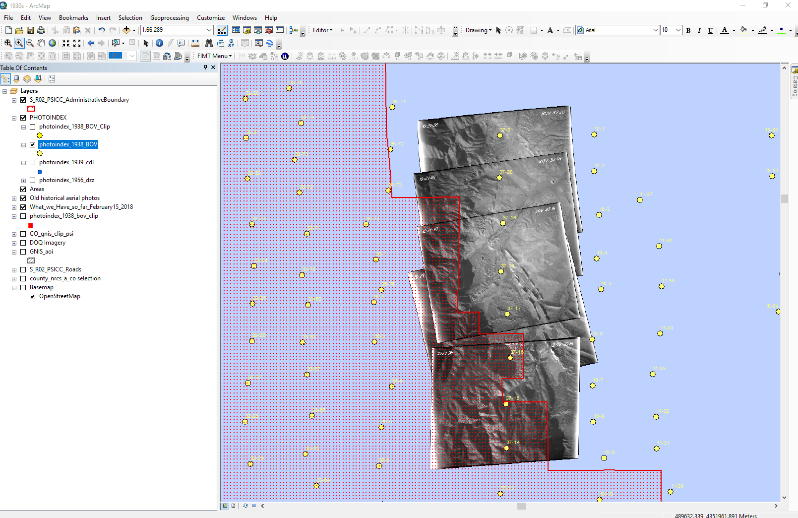
Overview of the Photo Index over the Pike and San Isabel National Forest ( See red hatch with red outline ). The points here you see is black dot color.

Zoom in smaller area and show you the attribute table.. Does not say Latitude and Longitude but How in the world did they put the point with the UTM reference ??

Here you go... and tell me i can go and find out more information..
This shapefile we have came from a contractor who does the scanning the aerial photos.
Now I select a point and use the identify tool to show me the information about that point..

Thoughts how did they do that ?
- Mark as New
- Bookmark
- Subscribe
- Mute
- Subscribe to RSS Feed
- Permalink
The Shape field has the actual coordinate information just like any other shapefile. You can get the longitude and latitude and/or UTM coordinates using tools in ArcMap that I am sure you have used before.
Each point in that shapefile denotes an associated photo... therefore your photos on their associated rolls are the ones that belong with that point.
That does not however mean that you can see the image on screen other than by hyperlinking (a totally separate issue) or manually opening up the photo.
I suspect that what you want to do is use... Mosaic Datasets to somehow create the big 'picture' that you want to see. I suspect that the point location might be something like the centre or something else of the photo.
If you can open one of the photos AND it has real world coordinates (like utm or long/lat) then your photos are gis ready.
If you don't see real world coordinates for your photos... you have a big job ahead of you and some reading and strategizing to do to formulate a work plan... this is where contracting out is useful 
- Mark as New
- Bookmark
- Subscribe
- Mute
- Subscribe to RSS Feed
- Permalink
Aww. I see. I am thinking that when the flight flew up in the air and the camera took pictures below and snapshot of each photo to denote that photo ? Correct ..
- Mark as New
- Bookmark
- Subscribe
- Mute
- Subscribe to RSS Feed
- Permalink
Robert....
in 1938, to use one of your dates...
- there were no digital cameras... the photos were printed on photo paper
- your photos are obviously scanned from the originals
- Shapefiles did not exist
- and there was no gps to auto-register a digital photo (since it didn't exist) with flight coordinates...
Someone scanned the photos... made the association between the photos and plane location and produce the shapefile locations which represented the flight plan.
- Mark as New
- Bookmark
- Subscribe
- Mute
- Subscribe to RSS Feed
- Permalink
Well, here I am done with georegistration using ERDAS Imagine 2016 using AutoSync.. It is not that bad but here is the screenshot of what I did.. so I have a lot of raw aerial photos that I have to do..so it is fun !
- « Previous
-
- 1
- 2
- Next »
- « Previous
-
- 1
- 2
- Next »