- Home
- :
- All Communities
- :
- User Groups
- :
- GIS Jobs
- :
- Questions
- :
- GEO tool required to extract state city town data ...
- Subscribe to RSS Feed
- Mark Topic as New
- Mark Topic as Read
- Float this Topic for Current User
- Bookmark
- Subscribe
- Mute
- Printer Friendly Page
GEO tool required to extract state city town data from map
- Mark as New
- Bookmark
- Subscribe
- Mute
- Subscribe to RSS Feed
- Permalink
I am developing a media portal and I am trying to define the circulation / broadcast area for the media (newspapers/magazines/radio/television) and extract states/cities/towns within the defined area to our database. This will enable users to search for media in specific regions/cities/towns.
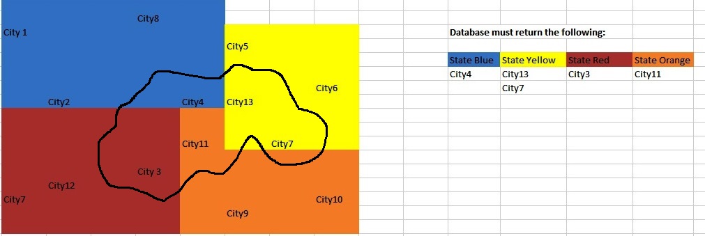
Please see the following example.
You can also see the following link of a company that has developed something very similar to what I need. However, their app returns all listed properties in an area where mine needs to return all regions/cities and towns. But the tool is exactly what I need. See http://www.zoopla.co.uk/for-sale/map/property/london/?q=London
As a quick solution, I would like to run a geoprocessing service within a web app, it's a pretty simple GIS task (select all points that fall within a defined area). If you know the circulation area (polygons) of each media, then querying the database to find all city points that fall within specific polygons is just a SQL statement or geoprocessing tool (select by location) away.
Also, we need to setup what size of town (based on population/area/etc.) if that data is available.
Furthermore, the user must be able to define several areas on the map and we need to limit user to specific country.
Many thanks and kind regards
Ivor van Rensburg
The Media Gateway
Mobile: +27 82 652 8050
Facsimile: +27 86 512 6940
Email: info@themediagateway.co.za
Skype: ivor.van.rensburg
- Mark as New
- Bookmark
- Subscribe
- Mute
- Subscribe to RSS Feed
- Permalink
If you know the circulation area (polygons?) of each media, then querying the database to find all city points that fall within specific polygons is just a SQL statement or geoprocessing tool (select by location) away.
[EDIT] If I read your question wrong, and you're looking at how to build (or have someone else build) a complete solution like the web app you linked to, there are plenty of tutorials and learning materials scattered throughout ESRI online resources on how to build a javascript web app through ArcGIS Online.
Web AppBuilder for ArcGIS | ArcGIS
Cheers,
Todd
- Mark as New
- Bookmark
- Subscribe
- Mute
- Subscribe to RSS Feed
- Permalink
Hi Todd
Thank you for your kind response. Just to clarify, I would like to provide the media with an easy graphical tool to define their circulation/broadcast area. I was thinking of a polygon tool similar to Zoopla's tool. Once they have defined the area, the tool must automatically record all cities and towns in that defined area. Currently, the media have to select each and every region/city/town from a long list - nearly impossible for some radio stations that broadcast over a vast area .
Once this is done, the purpose is for companies and agencies to search media in region/city/town.
I'm not very technical and I don't understand too much of this terminology.
Once again, thank you for your assistance.
I will appreciate it if you could point me in the right direction and maybe give me the correct terminology to use in search of an adequate solution.
If you don't mind and would prefer to have a Skype call, I would really appreciate it. I could show you exactly what I need.
Kind regards
Ivor
- Mark as New
- Bookmark
- Subscribe
- Mute
- Subscribe to RSS Feed
- Permalink
Hi again Ivor,
If I understand you correctly, you want to provide a web map that someone from the media can draw a polygon on. From that polygon, a list of cities/towns/etc that fall within it are then sent back to them as a result?
If this is the case, then running a geoprocessing service within a web app is the quick solution, as it's a pretty simple GIS task (select all points that fall within a defined area).
The next question is - do you have a web mapping service already and the capability to do this on your own? Or is this something that you're starting at zero?
- Mark as New
- Bookmark
- Subscribe
- Mute
- Subscribe to RSS Feed
- Permalink
The media draw the area and the result is stored in our database. The area is also displayed graphically on their profile.
We don't have anything at the moment, we would like to someone to develop it for us. Would you be interested or could you recommend someone ?
Just a few other questions:
1. Would the tool be able to select only major cities and towns, not every small town because this could strain the system.
2. Could one limit the user to a country
3. Would one be able to define several areas on one map ?
Many thanks
Ivor
- Mark as New
- Bookmark
- Subscribe
- Mute
- Subscribe to RSS Feed
- Permalink
To quickly answer:
- Yes you can setup what size of town (based on population/area/etc) if that data is available.
- Yes you can limit to country, or county or anything you wish.
- Yes you could run several areas on the map.
If you're looking for someone to develop this for you, I suggest posting your request (feel free to use the discussion here as a starting point to let other GIS developers know what you're looking for) to a board specifically for that. You shouldn't have a hard time finding someone in GeoNet who would be willing to take this on for you, depending on your resources.
- Mark as New
- Bookmark
- Subscribe
- Mute
- Subscribe to RSS Feed
- Permalink
Wow thanks Todd, I really appreciate your help.