Turn on suggestions
Auto-suggest helps you quickly narrow down your search results by suggesting possible matches as you type.
Cancel
- Home
- :
- All Communities
- :
- Products
- :
- Geoprocessing
- :
- Geoprocessing Questions
- :
- Re: Using Modelbuilder for a Monte Carlo Process
Options
- Subscribe to RSS Feed
- Mark Topic as New
- Mark Topic as Read
- Float this Topic for Current User
- Bookmark
- Subscribe
- Mute
- Printer Friendly Page
Using Modelbuilder for a Monte Carlo Process
Subscribe
3315
5
05-28-2014 07:38 AM
05-28-2014
07:38 AM
- Mark as New
- Bookmark
- Subscribe
- Mute
- Subscribe to RSS Feed
- Permalink
Hello,
I would like to create a model or write a script that will complete the following geoprocess:
If I have a layer of polygons, I need to place two random points in each polygon, create a line from those two points, and then check if that line falls within the polygon or not.
I am using ModelBuilder, and I am able to build a model that will create two random points within each polygon and then create a line between them. I am confident that I can figure out how to do the spatial join, but I am not sure how to use that to give me an output that essentially counts if it is inside the polygon or not.
I am unsure how to correctly set up the for - function and collecting the output data that I need.
Pseudocode:
for i=1 to 10000
Create two random points inside each polygon
Create line between those two points
Check if line falls completely within the polygon
Keep a count for each polygon if the line falls within polygon or not for each round through the loop
end
I figured I would ask if anyone had any examples they might be able to share that accomplished something similar, or if anyone had any suggestions as to how to build this model.
Much appreciated!
5 Replies
05-28-2014
08:31 AM
- Mark as New
- Bookmark
- Subscribe
- Mute
- Subscribe to RSS Feed
- Permalink
Eric,
You say you create 2 random points in each polygon then create line between them. Under what scenario would that line actually be outside the polygon? I could see a scenario of a line partially in a polygon (e.g. donut polygon) but both ends would be in the polygon.
Can you upload a sketch of what of a true and false scenario you are trying to test? It's not clear what you asking as your pseudo code appears to contradict your description?
Duncan
05-28-2014
08:58 AM
- Mark as New
- Bookmark
- Subscribe
- Mute
- Subscribe to RSS Feed
- Permalink
If your scenario is something like this:
[ATTACH=CONFIG]34135[/ATTACH]
Then I would first use the Feature Vertices to points to extract one end of the line this can then be used to do a spatial join with your polygons. Having assigned the polygon ID to the point you spatial join that back to the polyline. This guarantees the correct ID for the line. You use that to quality control your output. Then its just an intersect tool with output set to LINE. If your line ID's are duplicated then you must be passing out/into the polygon.
05-28-2014
09:24 AM
- Mark as New
- Bookmark
- Subscribe
- Mute
- Subscribe to RSS Feed
- Permalink
Thank you for your responses so far.
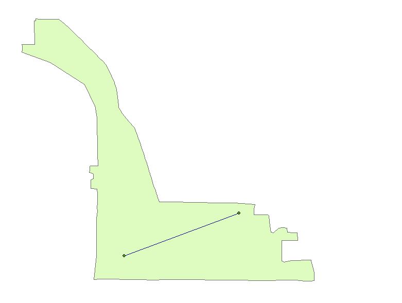
This is what I mean when I talk about the line. I need to know when it falls completely within the polygon. Here is an example of a census tract I picked from Ohio:
[ATTACH=CONFIG]34140[/ATTACH]
In that image, the line drawn between two points falls completely within the polygon.
Below, they do not:
[ATTACH=CONFIG]34141[/ATTACH]
05-28-2014
11:32 AM
- Mark as New
- Bookmark
- Subscribe
- Mute
- Subscribe to RSS Feed
- Permalink
Can you do a Select By Location specifying where the line is completely within the polygon? I don't work much with ModelBuilder, but that's what I'd do manually.
05-28-2014
12:11 PM
- Mark as New
- Bookmark
- Subscribe
- Mute
- Subscribe to RSS Feed
- Permalink
I know how to do a select by location of that nature - but is there a way to do it so that I get an output whether or not is was successfully able to select the line in question?
Thank you very much for your input!
Thank you very much for your input!