- Home
- :
- All Communities
- :
- Products
- :
- Geoprocessing
- :
- Geoprocessing Questions
- :
- Trilateration in ArcMap
- Subscribe to RSS Feed
- Mark Topic as New
- Mark Topic as Read
- Float this Topic for Current User
- Bookmark
- Subscribe
- Mute
- Printer Friendly Page
Trilateration in ArcMap
- Mark as New
- Bookmark
- Subscribe
- Mute
- Subscribe to RSS Feed
- Permalink
Hi I am trying to find a way to natively trilateral between three points in ArcMap, using the Distance-Distance construction feature I can do this with two measurements but is there a way to give a third input measurement?
I've also tried buffering each point by the distance and then running an intersect but the issue is, especially with hand collected data, if the records are not 100% accurate you are left with a "cocked hat" where the three circles do not intersect so the point has to be placed manually. this is also quite time intensive when you have multiple fixes to plot.
- Mark as New
- Bookmark
- Subscribe
- Mute
- Subscribe to RSS Feed
- Permalink
Use Mean center tool. mean center
Then use Point Distance tool to determine the distances from mean center to all 3 points .
- Mark as New
- Bookmark
- Subscribe
- Mute
- Subscribe to RSS Feed
- Permalink
Hi Abullah
This would assume that the the distances are all equally distant from each other which they are not. This is the maths behind trilateration: Trilateration - Wikipedia
- Mark as New
- Bookmark
- Subscribe
- Mute
- Subscribe to RSS Feed
- Permalink
This would assume that the the distances are all equally distant from each other which they are not.
????
Mean center is not the equal distance from each other points.
the following picture is the Mean Center to random 3 points.
I think that you want to do 3 circles intersect each other and not Trilateration.
Trilateration is not as your post picture.

in your Wikipedia link you will find the following picture:

look for intersection in 3 circles,it is an area and not a point as you want.
where the three circles do not intersect so the point has to be placed manually
.
- Mark as New
- Bookmark
- Subscribe
- Mute
- Subscribe to RSS Feed
- Permalink
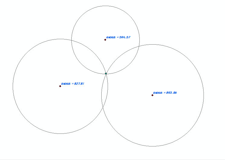
Mean Center tool doesn't calculate the Trilateration point, see below; is the center point of the triangle (base on weights) whereas the intersection point(or area) is a bit to the side


any other GP tools to recommend?
P.S. cannot use buffers intersect as sometimes there's 0 solutions.
