- Home
- :
- All Communities
- :
- Products
- :
- Geoprocessing
- :
- Geoprocessing Questions
- :
- Re: Spatial Analysis Question
- Subscribe to RSS Feed
- Mark Topic as New
- Mark Topic as Read
- Float this Topic for Current User
- Bookmark
- Subscribe
- Mute
- Printer Friendly Page
Spatial Analysis Question
- Mark as New
- Bookmark
- Subscribe
- Mute
- Subscribe to RSS Feed
- Permalink
Good evening everyone,
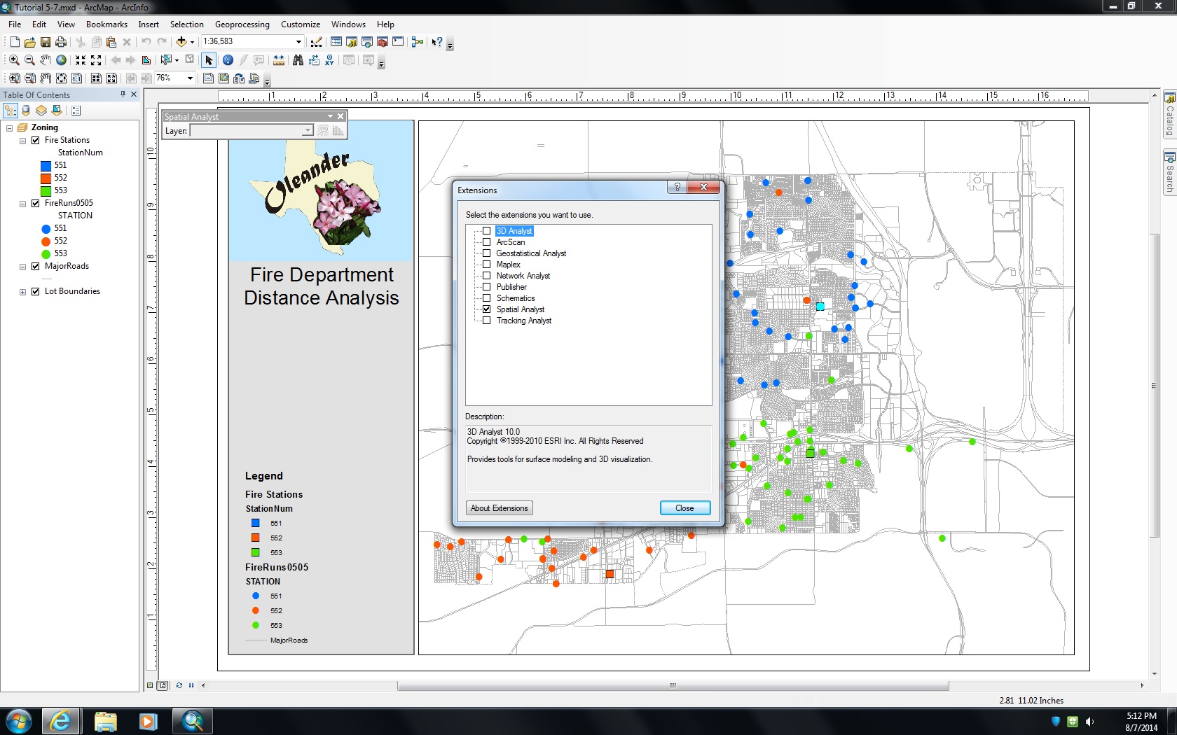
I am really stuck on an issue in ArcMap. It is regarding the Spatial Analyst toolbar. The instructions are to select:
Tools>Extentions>Spatial Analyst
View>Toolbars>Spatial Analyst
The issue is that the Spatial Analysis toolbar does indeed pop up in my GUI, but it is greyed out. It is not an administrator issue, because I am able to click the option, and no error message displays regarding that. The Spatial Analyst toolbar is simply greyed out. I had this issue in a previous exercise from the same book I am using, and was able to get around it. It is one of those situations where I cannot remember the 'workaround' that I did regarding the interface, etc. Any help is very much appreciated!
Thanks,
Justin Medley
- Mark as New
- Bookmark
- Subscribe
- Mute
- Subscribe to RSS Feed
- Permalink
I should add that in place of Tools and View in the directions, both Extentions and Toolbars are under the customize menu in my version of ArcMAP...
- Mark as New
- Bookmark
- Subscribe
- Mute
- Subscribe to RSS Feed
- Permalink
Do you have any raster data loaded?
The Spatial Analyst toolbar appears to stay greyed out unless there is some data it can use.
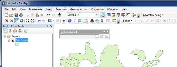
For example - before adding some raster data:
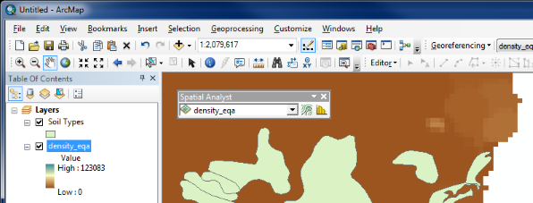
After adding some raster data:
This can be confusing as the greyed out toolbar appears exactly as it would if the extension was not enabled in Customize > Extensions.
- Mark as New
- Bookmark
- Subscribe
- Mute
- Subscribe to RSS Feed
- Permalink
The only way I am able to replicate this is if I don't have the Spatial Analyst Extension checked off when i go to Customize>Extentions
As a check to see, go to your Toolboxes and scroll down to the Spatial Analyst toolbox. If you have a license of Spatial Analyst working properly you should be able to open any of those tools and not receive an error message. If it's not installed properly or checked off in the Extentions, it will tell you are not licensed to use those toolboxes
- Mark as New
- Bookmark
- Subscribe
- Mute
- Subscribe to RSS Feed
- Permalink
Owen, the thing is, this exercise does not list any raster data required...so I am not sure what data I could use.
Jorge, I have it checked and it is loaded/enabled...so it is not an Administrator or License issue.
Thanks,
Justin
- Mark as New
- Bookmark
- Subscribe
- Mute
- Subscribe to RSS Feed
- Permalink
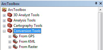
you should be able to go to Conversion Tools, To Raster, Feature to Raster if you have a spare shapefile...according to the help file, it does not require SA. Once you have a raster, try one of the tools in arctoolbox, for example, Spatial Analyst Tools, Map Algebra, Raster Calculator
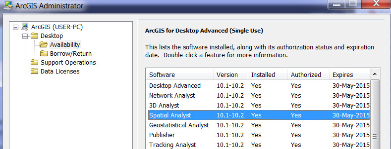
Also, in 10.2.2 as an example, go to the Start button (bottom left), select All programs, navigate to the ArcGIS folder and select the ArcGIS Administrator and ensure that the extension has been licensed (I know...I know...you have checked  )
)
- Mark as New
- Bookmark
- Subscribe
- Mute
- Subscribe to RSS Feed
- Permalink
Dan, where can I find the 'Conversion Tools'?
Sol, the exercise does not list any raster data for this exercise, and this is possibly the first exercise that requires this as opposed to vector data...so I am not entirely sure how the raster data works (file type, how to add, etc.)
I think the book wants me to use the Distance>Straight Line tool to create a 'bulls eye' around the feature. And then Combine rasters with the Raster Calculator. (now that I type this, I realize there must be a raster datafile somewhere, but I have no idea which to use from the files given by the book's cd) The final result it wants (an accompanying picture from the book displays it) is a football type shape that is basically a Venn Diagram "AND" relationship between two bulls eyes of data displayed.
Here is a screenshot:
- Mark as New
- Bookmark
- Subscribe
- Mute
- Subscribe to RSS Feed
- Permalink
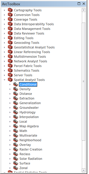
Open Arctoolbox (look for the little button that looks like a red toolbox)...that is where the real functionality of ArcMap lies...conversion tools is there as are the spatial analyst tools
- Mark as New
- Bookmark
- Subscribe
- Mute
- Subscribe to RSS Feed
- Permalink
The Spatial Analyst toolbar used to be packed with functionality before 10.0 was launched. It might be that the tutorial or part of the tutorial has not been updated to the current version. The only functionality that remains on the toolbar are those with user interaction on screen.
As explained by others in this thread the functionality you are looking for are all found in the ArcGIS Spatial Analyst toolbox.
- Mark as New
- Bookmark
- Subscribe
- Mute
- Subscribe to RSS Feed
- Permalink
To access ArcToolbox click on the button in the main toolbar:
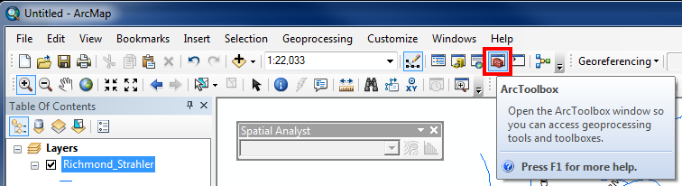
This should open the ArcToolbox window that contains all of the toolboxes - including the Conversion Tools and Spatial Analyst Tools. As Dan mentioned, the Conversion Tools contains a To Raster toolbox that you can use to create a new raster from a feature (Feature to Raster).
Also, as Xander points out the Spatial Analyst toolbar changed a lot from ArcGIS 9x to 10x. Do the examples in your book show a different Spatial Analyst toolbar than the images in my previous post?