- Home
- :
- All Communities
- :
- Products
- :
- Geoprocessing
- :
- Geoprocessing Questions
- :
- Re: Simplify building with orthogonal angles aka ...
- Subscribe to RSS Feed
- Mark Topic as New
- Mark Topic as Read
- Float this Topic for Current User
- Bookmark
- Subscribe
- Mute
- Printer Friendly Page
Simplify building with orthogonal angles aka creating rectangular building outlines
- Mark as New
- Bookmark
- Subscribe
- Mute
- Subscribe to RSS Feed
- Permalink
Hello,
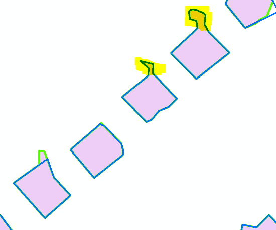
Our LiDAR data included a polygon building footprints. unfortunately the building footprints look more like blobs than actual building footprints. I would like to know if there is a way to convert the blobs into a generalized building footprint such that:
- All of the angles within a single building are at 90 degree angles.
- The entire building may be rotated if necessary - if the building itself is rotated like in the image below
- The building should not include any noise out of the predominant footprint. The highlighted areas in the image below should be removed.
Please note: I am not necessarily looking for "accurate" footprints. Instead I just footprints that (without any air photos turned on) look like they possibly could be building footprints.
Thanks
Image 1. Building footprints in purple. The building simplify and polygon simplify tasks help create nicer looking polygons but fail to create rectangular polygons that users would otherwise expect.
Solved! Go to Solution.
Accepted Solutions
- Mark as New
- Bookmark
- Subscribe
- Mute
- Subscribe to RSS Feed
- Permalink
GP tools in Pro are reading and writing the same data formats as 'Desktop'. The difference here is just what host is being used to run the tool. Yes, the tool will be in 'Desktop' (aka 'Classic') - that's what I meant by 10.4. Sorry, I know it's a bit confusing.
- Mark as New
- Bookmark
- Subscribe
- Mute
- Subscribe to RSS Feed
- Permalink
You can rule out
- convex hulls
- minimum area bounding rectangles (oriented) (MABR)
- some auto truncate algorithm
You could try
- Simplify Polygon—Help | ArcGIS for Desktop
- the following workflow on features with exterior fiddly bits
- buffer inward ( to pinch off extraneous bits) ,
- calculate area and remove the bits smaller than the desired minimum size,
- followed by an outward buffer by the same amount as the inner buffer
- perform a MABR now
- for features with corners etc pinched off
- MABR
- manually edit
- live with it
MABR can be found in Bounding Containers
it includes other container types. Useable with shapefiles as input and outputs... move to a gdb when you are done.
Some images Re: Ranking parcels according to the shape of their geometry (square\rectangular),
- Mark as New
- Bookmark
- Subscribe
- Mute
- Subscribe to RSS Feed
- Permalink
RegularizeBuildingFootprint was made for this - available in ArcGIS Pro 1.2 now. Will be in 10.4.
- Mark as New
- Bookmark
- Subscribe
- Mute
- Subscribe to RSS Feed
- Permalink
Can data modified in ArcGIS Pro be converted/exported to a format where it can still be used in ArcGIS Desktop?
Does ESRI have plans to make the RegularizeBuildingFootprint tool available in ArcGIS Desktop?
- Mark as New
- Bookmark
- Subscribe
- Mute
- Subscribe to RSS Feed
- Permalink
GP tools in Pro are reading and writing the same data formats as 'Desktop'. The difference here is just what host is being used to run the tool. Yes, the tool will be in 'Desktop' (aka 'Classic') - that's what I meant by 10.4. Sorry, I know it's a bit confusing.