- Home
- :
- All Communities
- :
- Products
- :
- Geoprocessing
- :
- Geoprocessing Questions
- :
- Select by location in Model builder.
- Subscribe to RSS Feed
- Mark Topic as New
- Mark Topic as Read
- Float this Topic for Current User
- Bookmark
- Printer Friendly Page
Select by location in Model builder.

- Mark as New
- Bookmark
- Subscribe to RSS Feed
- Permalink
I want to clip the USA population into individual rasters with counties boundaries as output extent. First, I want to select a county, then use select by location to select all the boundary touching counties. I want these selected features as the clipping extent of the output raster. The output is saved as the objectID of the initially selected county.
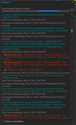
I used model builder, but I've problems. I'm successfully able to generate a raster for 1st county. But for the rest all, I'm getting errors. I've attached the pictures. Please help me.



- Mark as New
- Bookmark
- Subscribe to RSS Feed
- Permalink
The error suggests that all the data are not in the same coordinate system
... sort of retired...
- Mark as New
- Bookmark
- Subscribe to RSS Feed
- Permalink
The error persists even after I convert all the layers to the same coordinate system.
- Mark as New
- Bookmark
- Subscribe to RSS Feed
- Permalink
Perhaps show your map. You used the Project tool (for vector) and Project Raster (for raster) to do any necessary projections I presume.
... sort of retired...
- Mark as New
- Bookmark
- Subscribe to RSS Feed
- Permalink
I used the project tool for counties shapefile and project rasters for population data.

I was still getting the same error. But I don't understand is every time I run the model, the First clip was successfully created, and the further all are getting the error. Is it have to do anything with the feature iterate selection?
