Turn on suggestions
Auto-suggest helps you quickly narrow down your search results by suggesting possible matches as you type.
Cancel
- Home
- :
- All Communities
- :
- Products
- :
- Geoprocessing
- :
- Geoprocessing Questions
- :
- Run Thiessen polygons to a specific boundary shape...
Options
- Subscribe to RSS Feed
- Mark Topic as New
- Mark Topic as Read
- Float this Topic for Current User
- Bookmark
- Subscribe
- Mute
- Printer Friendly Page
Run Thiessen polygons to a specific boundary shapefile
Subscribe
4220
6
05-12-2010 02:53 PM
05-12-2010
02:53 PM
- Mark as New
- Bookmark
- Subscribe
- Mute
- Subscribe to RSS Feed
- Permalink
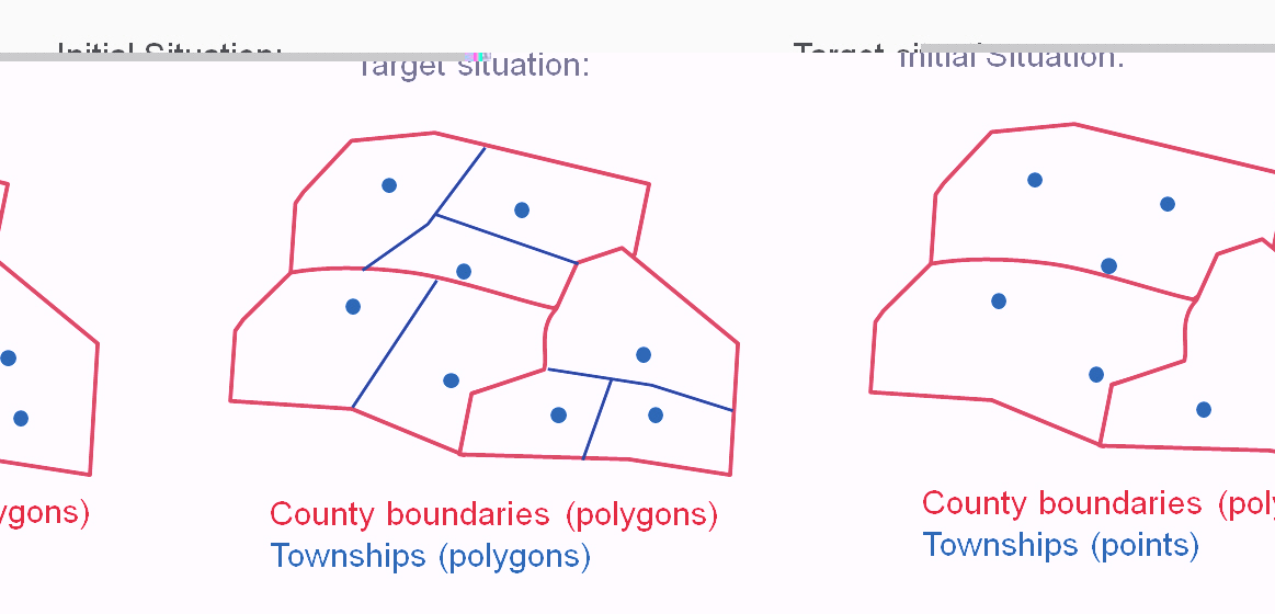
I have a point file with township info, but it has no corresponding polygons. I need to create a polygon file, such that for each given county (I do have the county polygon file), each centroid gives an estimated township boundaries which we can then turn into polygons. These polygons need to fit such that they are contained and define the boundary of each county.
6 Replies
06-07-2011
06:29 AM
- Mark as New
- Bookmark
- Subscribe
- Mute
- Subscribe to RSS Feed
- Permalink
Hi,
I have exactly the same problem... Unfortunately, I also do not have a solution. Did you find one in the mean time? Would be great if you could tell me more...
Regards, Jutta
I have exactly the same problem... Unfortunately, I also do not have a solution. Did you find one in the mean time? Would be great if you could tell me more...
Regards, Jutta
06-07-2011
09:45 AM
- Mark as New
- Bookmark
- Subscribe
- Mute
- Subscribe to RSS Feed
- Permalink
Why not just clip the Thiessen polygons to the county border?
06-08-2011
02:17 AM
- Mark as New
- Bookmark
- Subscribe
- Mute
- Subscribe to RSS Feed
- Permalink
The problem is, that there are many neighbouring polygons. That means if you clip polygons with the county border, there are "leftovers" of the Thiessen polygons in the neighbouring county polygons. Possibly it is easier to understand by looking at the attached jpg, where I tried to illustrate the problem.
06-08-2011
09:43 AM
- Mark as New
- Bookmark
- Subscribe
- Mute
- Subscribe to RSS Feed
- Permalink
If you were into scripting, you could:
For each county:
-Build a Thiessen polygon for just the points within the county
-Intersect the county boundary with the Thiessen polygon
Then merge all the intersect polygon outputs together.
For each county:
-Build a Thiessen polygon for just the points within the county
-Intersect the county boundary with the Thiessen polygon
Then merge all the intersect polygon outputs together.
06-14-2011
11:00 AM
- Mark as New
- Bookmark
- Subscribe
- Mute
- Subscribe to RSS Feed
- Permalink
Chris has the solution, but you could do the same iteration in ModelBuilder using Iterate Feature Selection (http://help.arcgis.com/en/arcgisdesktop/10.0/help/index.html#//00400000000s000000.htm
(assumes you have 10.0)
(assumes you have 10.0)
06-16-2011
06:42 AM
- Mark as New
- Bookmark
- Subscribe
- Mute
- Subscribe to RSS Feed
- Permalink
Chris and Dale, thank you for your help. Now it works!