Turn on suggestions
Auto-suggest helps you quickly narrow down your search results by suggesting possible matches as you type.
Cancel
- Home
- :
- All Communities
- :
- Products
- :
- Geoprocessing
- :
- Geoprocessing Questions
- :
- Re: Removing Linear Polygons
Options
- Subscribe to RSS Feed
- Mark Topic as New
- Mark Topic as Read
- Float this Topic for Current User
- Bookmark
- Subscribe
- Mute
- Printer Friendly Page
Removing Linear Polygons
Subscribe
7725
12
07-19-2011 05:53 AM
07-19-2011
05:53 AM
- Mark as New
- Bookmark
- Subscribe
- Mute
- Subscribe to RSS Feed
- Permalink
I have a set of tree classifications that have been acquired from a different software and have loaded them into ArcMap. I am wanting to find the main tree clusters and have had no problem doing that, by buffering them. but the problem is that the rule set created for the classification has included long linear areas which are not required. Some areas branch off from the main clusters and are therefore included in my final tree cluster area. I am therefore in need of a method that can help me remove these long linear polygons whilst keeping the main clusters. Can anybody help please?
12 Replies
07-19-2011
08:30 AM
- Mark as New
- Bookmark
- Subscribe
- Mute
- Subscribe to RSS Feed
- Permalink
Have you tried looking at the ratio of the polygon's area to its perimeter? A long, thin polygon would have a relatively low ratio compared to one that is more square or round.
07-20-2011
01:36 AM
- Mark as New
- Bookmark
- Subscribe
- Mute
- Subscribe to RSS Feed
- Permalink
I assume the fingers are part of the larger polygons? So they are not easy to identify with spatial indexes that measure ratios. If you have a grid licence you could convert to rasters and run expand/shrink processes that removes the slivers.
07-21-2011
03:41 AM
- Mark as New
- Bookmark
- Subscribe
- Mute
- Subscribe to RSS Feed
- Permalink
Bruce, I haven't looked at the ratio or perimeter to area. But thinking about it will it work because there are attached to the larger polygons I want to keep so surely the long thin areas will be included in the area and polygon of the larger square ones.
And Kimo yes the fingers are part of the larger polygons and thanks I will look into your idea.
And Kimo yes the fingers are part of the larger polygons and thanks I will look into your idea.
07-21-2011
06:53 AM
- Mark as New
- Bookmark
- Subscribe
- Mute
- Subscribe to RSS Feed
- Permalink
Another alternative is the old round-about polygon smoothing routine:
1. buffer the polygon an appropriate amount outwards
2. buffer that polygon double that distance inwards (a negative distance)
3. buffer the new polygon outwards the original distance
There is also the Simplify Building tool that may be of use. It is designed to generalize shapes with short sides and extensions. It may or may not work for your need here; your polygons may have too many sides.... ?
07-22-2011
01:12 AM
- Mark as New
- Bookmark
- Subscribe
- Mute
- Subscribe to RSS Feed
- Permalink
Eliminate could possibly work but the outcome of this is to provide a automatic process for main tree cluster capture over any area. Surely if I use the Eliminate tool I will have to do a manual select and as some are attached to the main tree clusters will this not also remove them as well?
07-22-2011
09:17 AM
- Mark as New
- Bookmark
- Subscribe
- Mute
- Subscribe to RSS Feed
- Permalink
The idea of using the ratio of the polygon's area to its perimeter can be helpful to some extent, but polygons with the same ratio may have very different sizes and the ratio won't reflect a narrow/length "branch" of a polygon.
Running the Buffer tool with a negative distance (a bit more than half of the average width of the linear polygons or branches) is more effective because a narrow or small portion of a polygon or entire polygon will not receive a buffer. If a buffer cannot be produced for an input polygon, the FID of the polygon will be reported by the buffer tool. You can use the input polygons to intersect the resulting buffer polygons. The input polygons that find no resulting buffer polygons are the linear or small polygons that you may exclude.
It is not easy to find and remove a linear branch of a polygon with existing tools. Perhaps a new tool needs to be developed.
Perhaps you can post an image or sample data to show the tree clusters and the linear polygons. Are the trees point or polygon features to begin with? If they are points, you can try the Aggreate Points tool (ArcGIS 10, arcinfo licensing). Linearly distributed points may not become polygons.
Regards,
07-25-2011
02:19 AM
- Mark as New
- Bookmark
- Subscribe
- Mute
- Subscribe to RSS Feed
- Permalink
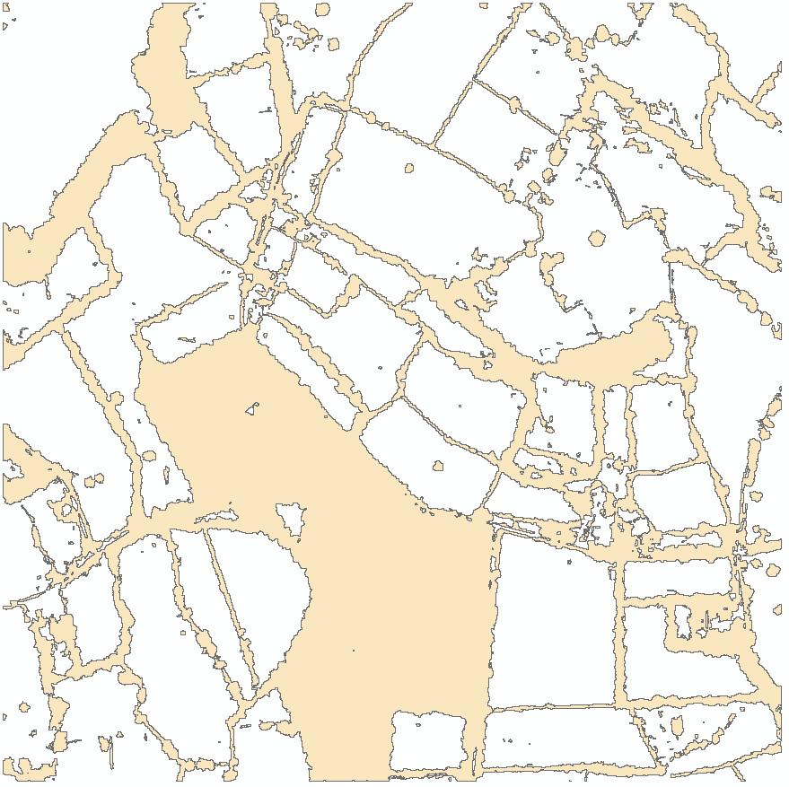
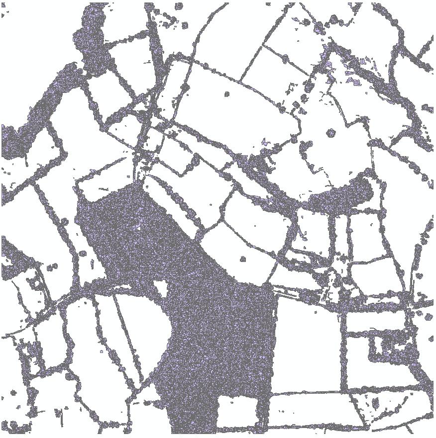
Thanks Dan. Please find attached screenshots of the data. The original data is lots of polygon data that was dissolved to create single areas of tree clusters.
I have used inner buffers to do this and then created a buffer that was slightly larger then the original extent to denote the larger tree clusters that I am looking for, but was wondering if there was another way of carrying out the task at hand. Using the dissolve tool I had to then use the multipart to singlepart tool in order to try and reduce connectivity between features but as can be seen it is still a slight issue with this data set.
Thanks again
Andrew
07-26-2011
11:03 AM
- Mark as New
- Bookmark
- Subscribe
- Mute
- Subscribe to RSS Feed
- Permalink
Andrew, thank you for providing the images. It seems no easy way to avoid the linear areas with existing tools. Using the inner buffers could help disconnect some of them, but I can imagine that the end result may still not be ideal; manual editing might be necessary.
On another thought, some raster tools might be helpful. I am not all familiar with the detailed tools, but check the Generalization Toolset, if you have access to Spatial Analyst.
Good luck!
On another thought, some raster tools might be helpful. I am not all familiar with the detailed tools, but check the Generalization Toolset, if you have access to Spatial Analyst.
Good luck!