Turn on suggestions
Auto-suggest helps you quickly narrow down your search results by suggesting possible matches as you type.
Cancel
- Home
- :
- All Communities
- :
- Products
- :
- Geoprocessing
- :
- Geoprocessing Questions
- :
- Re: Problem with dissolving buffer
Options
- Subscribe to RSS Feed
- Mark Topic as New
- Mark Topic as Read
- Float this Topic for Current User
- Bookmark
- Subscribe
- Mute
- Printer Friendly Page
Problem with dissolving buffer
Subscribe
5792
5
04-02-2014 04:32 AM
04-02-2014
04:32 AM
- Mark as New
- Bookmark
- Subscribe
- Mute
- Subscribe to RSS Feed
- Permalink
Hi everybody!
Maybe somebody can help me with this problem. I have a point shapefile (nests locations). I've plotted a 300m. buffer around each nest using the Buffer tool of "Geoprocessing". I would need to join those buffers that are in contact. I tried to do it using dissolve but the result is not correct because the new shape file has only a row (all the buffers have been joined at the same time)
Whats the correct way to do that?
I apologize if that's a too much simple question for most of you, I'm an absolute beginner in Gis
Thanks in advance!
Gus
5 Replies
04-02-2014
05:15 AM
- Mark as New
- Bookmark
- Subscribe
- Mute
- Subscribe to RSS Feed
- Permalink
Hi everybody!
Maybe somebody can help me with this problem. I have a point shapefile (nests locations). I've plotted a 300m. buffer around each nest using the Buffer tool of "Geoprocessing". I would need to join those buffers that are in contact. I tried to do it using dissolve but the result is not correct because the new shape file has only a row (all the buffers have been joined at the same time)
Whats the correct way to do that?
I apologize if that's a too much simple question for most of you, I'm an absolute beginner in Gis
Thanks in advance!
Gus
You have two options. 1. Uncheck the Multipart feature option in the Dissolve tool. 2. Use the Multipart to Singlepart tool on the current dissolve output.
04-02-2014
05:43 AM
- Mark as New
- Bookmark
- Subscribe
- Mute
- Subscribe to RSS Feed
- Permalink
You have two options. 1. Uncheck the Multipart feature option in the Dissolve tool. 2. Use the Multipart to Singlepart tool on the current dissolve output.
Thanks for your help, rfairhur .
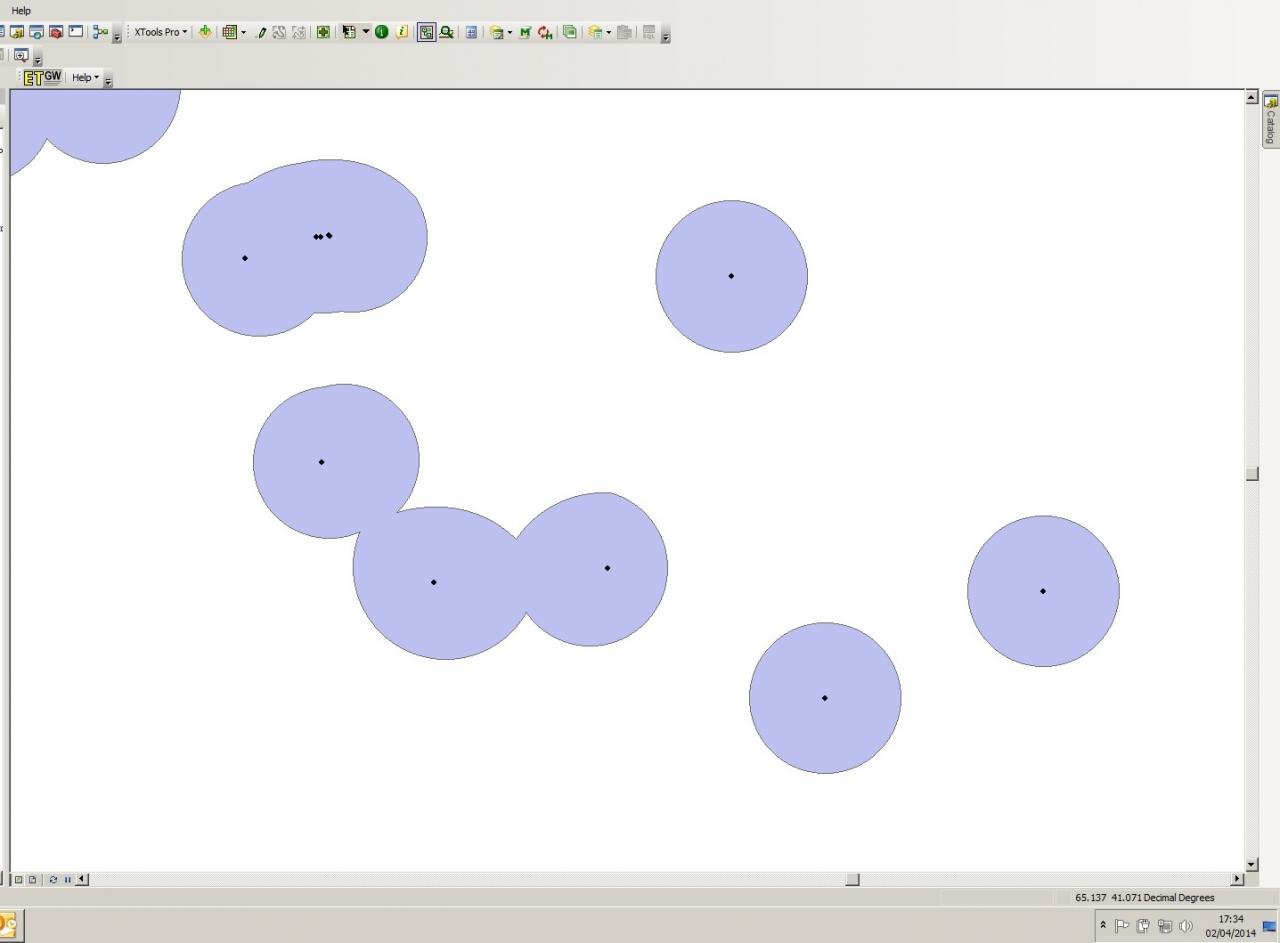
Your reply has been very useful. Both systems works. But I don't know why when I apply the dissolve tool my new polygons are deformed
I attach a print screen of that
Do you have any idea about the cause of that deformation?
Thanks again!
04-02-2014
07:15 AM
- Mark as New
- Bookmark
- Subscribe
- Mute
- Subscribe to RSS Feed
- Permalink
Thanks for your help, rfairhur .
Your reply has been very useful. Both systems works. But I don't know why when I apply the dissolve tool my new polygons are deformed
I attach a print screen of that
Do you have any idea about the cause of that deformation?
Thanks again!
Are you saying this is not what was generated by the Buffer tool and that the shape only occurred after using the Dissolve tool? Or do these distorted shapes occur as soon as buffers are generated?
I don't know what spatial reference you are using. A Geographic Coordinate System, such as the one used by Google Earth, may be the cause of the distortion if these nests are spread over a wide area. If your coordinates are reported in decimal degrees this type of projection is being used. Only Projected Coordinate Systems that are usually more localized report coordinates in distance units like meters or feet.
Another possibility is that the resolution or tolerance of the layer is too high and that is causing the tool to generalize the shape. In any case there are several potential causes that cannot be determined without more information about the data sources you are using.
Open the layer properties for your original point input layer and screenshot the Source tab properties to show us the relevant information to determine if any of my suggestions may apply.
04-02-2014
09:06 AM
- Mark as New
- Bookmark
- Subscribe
- Mute
- Subscribe to RSS Feed
- Permalink
Are you saying this is not what was generated by the Buffer tool and that the shape only occurred after using the Dissolve tool? Or do these distorted shapes occur as soon as buffers are generated?
I don't know what spatial reference you are using. A Geographic Coordinate System, such as the one used by Google Earth, may be the cause of the distortion if these nests are spread over a wide area. If your coordinates are reported in decimal degrees this type of projection is being used. Only Projected Coordinate Systems that are usually more localized report coordinates in distance units like meters or feet.
Another possibility is that the resolution or tolerance of the layer is too high and that is causing the tool to generalize the shape. In any case there are several potential causes that cannot be determined without more information about the data sources you are using.
Open the layer properties for your original point input layer and screenshot the Source tab properties to show us the relevant information to determine if any of my suggestions may apply.
Hi again rfairhur24
Yes ArcMap makes the buffers accurately but these distorted shapes appear as a result of the dissolve process )only distorts those buffers that are in contact and so change shape after dissolve )the isolated one remains .
I projected the layer to UTM. Here you are the coordinate systems in a prt sc I hope it helps to understand
Thanks again
04-02-2014
10:40 AM
- Mark as New
- Bookmark
- Subscribe
- Mute
- Subscribe to RSS Feed
- Permalink
Hi again rfairhur24
Yes ArcMap makes the buffers accurately but these distorted shapes appear as a result of the dissolve process )only distorts those buffers that are in contact and so change shape after dissolve )the isolated one remains .
I projected the layer to UTM. Here you are the coordinate systems in a prt sc I hope it helps to understand
Thanks again
If this output is to a geodatabase then the circles are true curves, which may behave badly when cut. Shapefiles don't use true curves, so if it is a shapefile then I am less certain why it is distorting. Assuming it is a geodatabase output, first make a copy of your buffers and then try the Densify tool on the circles first to make them convert to many individual very small straight lines that approximate a circle and then try the Dissolve tool. Apply a fairly small maximum distance to make sure the curve approximation is reasonably good. This tool modifies the input data directly without creating a back up for you, so make a copy first before using it so you can refine the settings without having to redo the buffers.