- Home
- :
- All Communities
- :
- Products
- :
- Geoprocessing
- :
- Geoprocessing Questions
- :
- Re: Model Builder raster extract leads to invalid ...
- Subscribe to RSS Feed
- Mark Topic as New
- Mark Topic as Read
- Float this Topic for Current User
- Bookmark
- Subscribe
- Mute
- Printer Friendly Page
Model Builder raster extract leads to invalid table name
- Mark as New
- Bookmark
- Subscribe
- Mute
- Subscribe to RSS Feed
- Permalink
I am trying to use Model Builder with Extract with Mask. The masks (polygons) are in a file database and the raster is a standalone GRID. When I run the model it exits with an error that is the Table name is invalid. I tried to investigate the meaning and I came across two explanations. One: don't start names with digits. Two: names can't be longer than 13 characters. I think I've met those restrictions, but I still get the error. I think I also read somewhere that you should save to a database, but I swear I've done something similar to this months back and saved in a folder without problem. I'm out of ideas at this point. 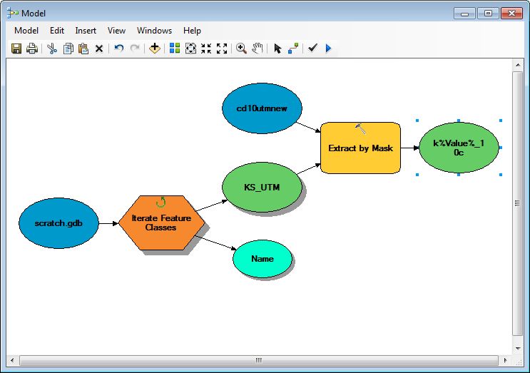
Solved! Go to Solution.
Accepted Solutions
- Mark as New
- Bookmark
- Subscribe
- Mute
- Subscribe to RSS Feed
- Permalink
As far as I can tell, there is no such variable as %Value%, but there is %Name%.
- Mark as New
- Bookmark
- Subscribe
- Mute
- Subscribe to RSS Feed
- Permalink
path can't contain spaces or other unsavory characters (except _ ) and the total path plus filename must be less than 125ish characters. Also, if you dont specify a file extension, you will get an esri grid which is fine.
- Mark as New
- Bookmark
- Subscribe
- Mute
- Subscribe to RSS Feed
- Permalink
Does the spatial reference of the featureclasses match the spatial reference of the raster?
How about the geoprocessing environment setting... how is the extent defined?
What are the values for %Value%?
If you copy import the raster into the file geodatabase, and run the model with that raster does the problem occur too?
- Mark as New
- Bookmark
- Subscribe
- Mute
- Subscribe to RSS Feed
- Permalink
Xander, the projections match for the masks and the raster. I did not change the extent, so it'd be whatever the default is... I think a reply after yours hit the nail with pointing out that I had used "%Value%", instead of "%Name%", so you were on to something. Thanks for the help!
- Mark as New
- Bookmark
- Subscribe
- Mute
- Subscribe to RSS Feed
- Permalink
As far as I can tell, there is no such variable as %Value%, but there is %Name%.
- Mark as New
- Bookmark
- Subscribe
- Mute
- Subscribe to RSS Feed
- Permalink
Darren is on to something...I suspect Value was supposed to be a field in the raster table, which hasn't been set as a variable
- Mark as New
- Bookmark
- Subscribe
- Mute
- Subscribe to RSS Feed
- Permalink
DINGDINGDINGDING... the winner! You were right, Darren, I referred to a non-existent variable. Thanks a lot for the help!