- Home
- :
- All Communities
- :
- Products
- :
- Geoprocessing
- :
- Geoprocessing Questions
- :
- Re: Geostatistical layer to raster empty
- Subscribe to RSS Feed
- Mark Topic as New
- Mark Topic as Read
- Float this Topic for Current User
- Bookmark
- Subscribe
- Mute
- Printer Friendly Page
Geostatistical layer to raster empty
- Mark as New
- Bookmark
- Subscribe
- Mute
- Subscribe to RSS Feed
- Permalink
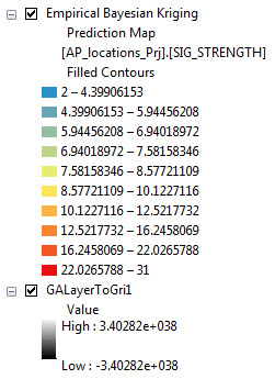
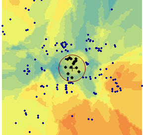
I'm running ArcGIS 10.2 and have been using the Geostatistical Wizard to create an interpolation layer using ordinary kriging. The Wizard has successfully run the kriging operation and produced a geostatistical layer output, which looks quite reasonable. However, when I try to export the GA layer to a raster (I've tried both GA Layer to Grid and Data->Export to Raster from the TOC) the resulting raster is empty. The range of the raster layer as shown in the TOC is -3.4...e+038 to 3.4...e+038, and when I open the properties for the layer, no summary stats are shown. Calculating Statistics is not doing anything, it runs, but doesn't change the summary stats and the raster still appears empty. The projection information of the original point data and the output raster match. Herewith attached the Jpeg which shows the geostatistical result and exported result with -3.4...e+038 to 3.4...e+038
Let me know if I'm missing something...Please advise!
- Mark as New
- Bookmark
- Subscribe
- Mute
- Subscribe to RSS Feed
- Permalink
Ravi
Please post an image of the preview page in the Wizard.
Do you have any environments set?
Did you change the cell size?
What do you get from GALayerToContour?
BTW Data->Export to Raster from the TOC does not work against a GA layer
-Steve
- Mark as New
- Bookmark
- Subscribe
- Mute
- Subscribe to RSS Feed
- Permalink
and the rest of the questions?
- Mark as New
- Bookmark
- Subscribe
- Mute
- Subscribe to RSS Feed
- Permalink
What does "rest of the questions" mean?
- Mark as New
- Bookmark
- Subscribe
- Mute
- Subscribe to RSS Feed
- Permalink
If the result is a floating point raster, it will have no table... is that what you are expecting? and as Steve says... too little information forthcoming so far
- Mark as New
- Bookmark
- Subscribe
- Mute
- Subscribe to RSS Feed
- Permalink
Do you have any environments set?
Did you change the cell size?
What do you get from GALayerToContour?
and, all output from the interpolations are floating point.
- Mark as New
- Bookmark
- Subscribe
- Mute
- Subscribe to RSS Feed
- Permalink
Ravi
You do realize that the EmpiricalBayesianKriging geoprocessing tool can output to a geostatistical layer or to a raster or to both?
-Steve
- Mark as New
- Bookmark
- Subscribe
- Mute
- Subscribe to RSS Feed
- Permalink
Yes. I did. the raster out put gave the result with -3.4...e+038 to 3.4...e+038