Turn on suggestions
Auto-suggest helps you quickly narrow down your search results by suggesting possible matches as you type.
Cancel
- Home
- :
- All Communities
- :
- Products
- :
- Geoprocessing
- :
- Geoprocessing Questions
- :
- Re: Different EPSG values
Options
- Subscribe to RSS Feed
- Mark Topic as New
- Mark Topic as Read
- Float this Topic for Current User
- Bookmark
- Subscribe
- Mute
- Printer Friendly Page
Different EPSG values
Subscribe
3719
3
04-23-2014 01:29 PM
04-23-2014
01:29 PM
- Mark as New
- Bookmark
- Subscribe
- Mute
- Subscribe to RSS Feed
- Permalink
Hello All,
I got a geo-TIFF with
Projection: UTM
Datum: WGS84
Zone: 18
The EPSG Code is 32617
I Re-projected the same image to NAD83
Projection: UTM
Datum: NAD83
Zone: 18
The EPSG Code is 26918 (correct)
Does any one know why this discrepancy occurs?
I heard that ESRI not current with EPSG processing or something like that.
Thanks,
Samuel
3 Replies
04-23-2014
01:35 PM
- Mark as New
- Bookmark
- Subscribe
- Mute
- Subscribe to RSS Feed
- Permalink
While Esri does trail the EPSG Dataset because of release cycles, EPSG:32617 has been 32617 for a very long time and has never had any changes. If you dump the geotiff headers with listgeo.exe or something similar, are the projection parameters there? Do they match the EPSG code or the listed zone? Did Esri software create the geotiff?
Melita
Melita
04-23-2014
01:52 PM
- Mark as New
- Bookmark
- Subscribe
- Mute
- Subscribe to RSS Feed
- Permalink
Hello Melita,
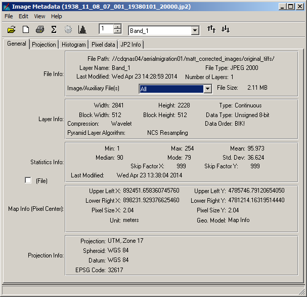
The geo-referenced aerial photographs (JP2 format) were probably created by ESRI software (by Vendor). The Projection should have been UTM NAD83 Zone18. Instead for some reason few were re-sampled to UTM WGS84 Zone 17. Re-projecting it solved the issue.
[ATTACH=CONFIG]33304[/ATTACH]
[ATTACH=CONFIG]33305[/ATTACH]
Thanks,
Samuel