Turn on suggestions
Auto-suggest helps you quickly narrow down your search results by suggesting possible matches as you type.
Cancel
- Home
- :
- All Communities
- :
- Products
- :
- Geoprocessing
- :
- Geoprocessing Questions
- :
- Determine points upstream or downstream of other f...
Options
- Subscribe to RSS Feed
- Mark Topic as New
- Mark Topic as Read
- Float this Topic for Current User
- Bookmark
- Subscribe
- Mute
- Printer Friendly Page
Determine points upstream or downstream of other features on a river network?
Subscribe
2339
1
02-26-2014 02:31 PM
02-26-2014
02:31 PM
- Mark as New
- Bookmark
- Subscribe
- Mute
- Subscribe to RSS Feed
- Permalink
Given a set of points along a complex river network, and a set of municipal district polygons covering the points and rivers... how would you determine for each point if it was 'upstream' or 'downstream' of the closest municipality along the same river the point is situated on?
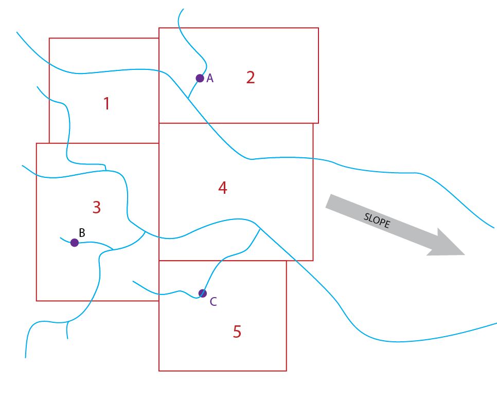
See the attached image for a simplified version of what I'm trying to help someone do. Basically we have mines (A B & C), situated along a river network. And we have municipalities (1 2 3 4 & 5). I don't care about the municipality the mine is in, but I ant to know if each mine is upstream or downstream on the next closest municipality on the same river.
This seems like a simple question, but the problem is in how to connect the mines to the municipalities on their network when there is no common identifier for the river segments they are on.
So for mine B, how do I get the upstream/downstream value for municipality 4 rather than 5?
One solution would be to simply get an elevation value at the mine and at the intersection of the river the mine is on at the municipal boundary, but I have no way to associate them. In the real data the boundary between each municipality is crossed by dozes of streams each.
Still working this out but would love some suggestions.
Dave
1 Reply
03-07-2014
10:23 AM
- Mark as New
- Bookmark
- Subscribe
- Mute
- Subscribe to RSS Feed
- Permalink
Hi:
I think this is similar to a problem I posted in the cartography forum. The suggestion was to try the Sector Analysis tools. I think it may require getting the stream bearing. Steve Aalbers
I think this is similar to a problem I posted in the cartography forum. The suggestion was to try the Sector Analysis tools. I think it may require getting the stream bearing. Steve Aalbers