- Home
- :
- All Communities
- :
- Products
- :
- Geoprocessing
- :
- Geoprocessing Questions
- :
- Re: Copy features a number of times based on a num...
- Subscribe to RSS Feed
- Mark Topic as New
- Mark Topic as Read
- Float this Topic for Current User
- Bookmark
- Subscribe
- Mute
- Printer Friendly Page
Copy features a number of times based on a numeric field value
- Mark as New
- Bookmark
- Subscribe
- Mute
- Subscribe to RSS Feed
- Permalink
I have a point feature class with a Count field. I want to copy each feature in the feature class a number of times based on the number in the Count field. For example, if a feature has a Count value of 6, I want six new features created with all the same attributes as the original feature.
All the iteration model tools I can find want to group features based on an attribute value, but I want the number of iterations to be equal to the numeric value in my Count field.
Thanks
Solved! Go to Solution.
- Mark as New
- Bookmark
- Subscribe
- Mute
- Subscribe to RSS Feed
- Permalink
As you suggested, I made a toolbox tool from the script and it works perfectly for points. A funny thing happens when I try it with polygons though (after changing the feature type to POLYGON in the script). It seems to work and produces a polygon layer, complete with a table representing the duplicated features. But the polygons will not draw. If I zoom to the full extent of the feature class, it zooms to the world, but if I zoom to any particular feature, the extent does not move at all. I don't really need this tool for polygons right now, but am curious as to that particular behavior.
PS, what do you normally work on with GIS? Any tips for learning python without taking expensive ESRI classes?
Cheers,
Seth
- Mark as New
- Bookmark
- Subscribe
- Mute
- Subscribe to RSS Feed
- Permalink
There are so many resources on the Internet that can help you to learn Python, it is to much to mention.
One way is to do a search in GeoNet: https://community.esri.com/search.jspa?q=learn+python or just Google it.
You will find a large number of post with lots of like to different sites like:
If you are willing to pay for a book, then this post references a very good book:
I have posted some Python Snippets that might help:
- Mark as New
- Bookmark
- Subscribe
- Mute
- Subscribe to RSS Feed
- Permalink
Seth, I'm trying to accomplish this as well (with points only), but I'm not very skilled in scripts. I also tried the data interoperability tool mentioned and failed. I've spent more time trying to do this than I care to mention and for several years I have been manually doing this for tens of thousands of features (bird detections). This sure would be a game changer for me and our little NGO. I've tried several times with the python provided, but I couldn't overcome the errors. I know it has been a while, but could you share the modelbuilder with me or let me know how you accomplished this?
Thanks!
Ethan
- Mark as New
- Bookmark
- Subscribe
- Mute
- Subscribe to RSS Feed
- Permalink
If it is a process that you will repeat, it might be good to create a tool from the script. Can you provide a sample of your data and a brief explanation of which field contains the number a feature should be repeated? Also please provide the version of the software you have ArcMap or ArcGIS Pro. I will see if I can create the tool for you so you can run this more easily. Anyway, for other workflows it might come in handy to learn some python.
- Mark as New
- Bookmark
- Subscribe
- Mute
- Subscribe to RSS Feed
- Permalink
Thanks for reaching out, Xander. I've provided a link to the data, here. The field containing the number for which each feature is to be repeated by is "Count_". All attributes need to remain the same. It would be great if the count field for the copied records was change to one, but that can be done easily enough after an otherwise successful script run. I'm using the latest version of ArcMap 10.5.0.6491. I hear you on the need to learn Python. I'm completely self-taught in GIS. It's been years of banging of my head against wall until I found solutions and workflows that would have been much easier to accomplish if I knew python. I've got my hands full running our small NGO that covers a lot of ground. I'll work on learning more from the resources mentioned above.
- Mark as New
- Bookmark
- Subscribe
- Mute
- Subscribe to RSS Feed
- Permalink
Hi Ethan Duke ,
A small correction,the current version of ArcMap is 10.6 (10.6.0.8321). I just changed the code to create the tool and to do a test run. The updated code is:
def main():
import arcpy
import os
# parameters of tool
fc_in = arcpy.GetParameterAsText(0)
fld_count = arcpy.GetParameterAsText(1)
fc_out = arcpy.GetParameterAsText(2)
# create the empty output featureclass
arcpy.AddMessage("Create output featureclass...")
sr = arcpy.Describe(fc_in).spatialReference
shp_type = (str(arcpy.Describe(fc_in).shapeType)).upper()
path, name = os.path.split(fc_out)
arcpy.CreateFeatureclass_management(path, name, shp_type, fc_in, "SAME_AS_TEMPLATE", "SAME_AS_TEMPLATE", sr)
# insert the features into the output fc
cnt_feats = 0
with arcpy.da.SearchCursor(fc_in, '*') as curs_in:
flds_in = curs_in.fields
idx_cnt = flds_in.index(fld_count)
with arcpy.da.InsertCursor(fc_out, '*') as curs_out:
for row in curs_in:
cnt = row[idx_cnt]
lst_row = list(row)
lst_row[idx_cnt] = 1
row_out = tuple(lst_row)
for i in range(0, cnt):
cnt_feats += 1
if cnt_feats % 1000 == 0:
arcpy.AddMessage("Writing feature: {}".format(cnt_feats))
curs_out.insertRow(row_out)
arcpy.AddMessage("Finished writing {} features...".format(cnt_feats))
if __name__ == '__main__':
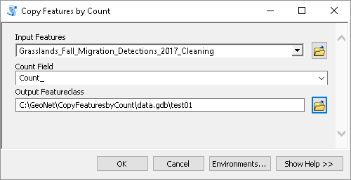
main()The tool will look like this:

When I did some test runs the feature get duplicated based on the selected count field and the count field is reset to 1.
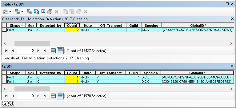
I did notice that your data has a GlobalID field. The problem with a GlobalID field is when write the the feature the GlobalID is changed in the output:

Do you have any attachments related to the points?
I can attach the toolbox, but possibly you won't be able to open it with ArcMap 10.5. I could create a 10.3 version at home which will be compatible with 10.5 that you have.
- Mark as New
- Bookmark
- Subscribe
- Mute
- Subscribe to RSS Feed
- Permalink
Hi, xander_bakker,
This is great. I'm working remotely and will secure more robust internet and update ArcMap (within 48 hours). The attachments and/or GUID are not necessary with this particular feature class after this stage of the workflow. I will work on this ASAP with results. Thank you!!
- Mark as New
- Bookmark
- Subscribe
- Mute
- Subscribe to RSS Feed
- Permalink
Hi Ethan Duke ,
I have attached the toolbox (10.6). If you have any problems upgrading to 10.6 or with the toolbox, just let me know and I see what I can do.
Kind regards, Xander
- Mark as New
- Bookmark
- Subscribe
- Mute
- Subscribe to RSS Feed
- Permalink
Hi Xander,
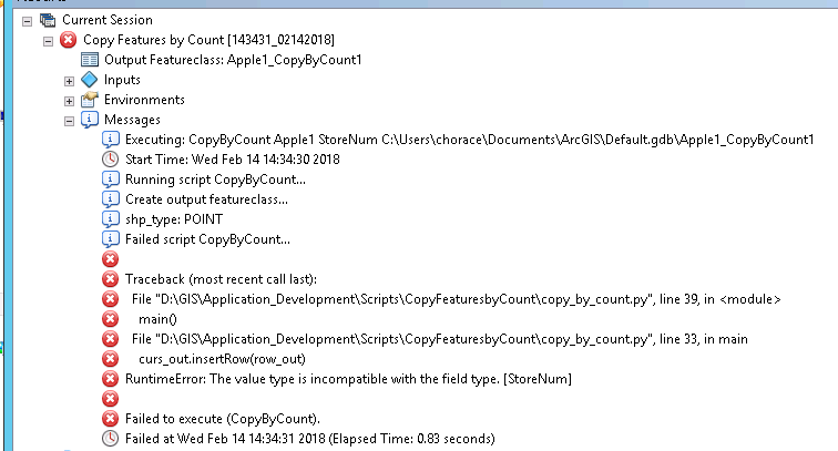
This is an excellent tool. However, I can not get it to work with a geodatabase or sde input. Is there something that I need to change? Any help would be greatly appreciated. Screenshot below:

- Mark as New
- Bookmark
- Subscribe
- Mute
- Subscribe to RSS Feed
- Permalink
Hi collinhorace ,
The error refers to a specific field called "StoreNum". Can you verify what type of field it is in both input and output featureclass and specify if the input and output featureclass are in different types of workspaces? I see the output is written to the default file geodatabase. Where is the input stored?