- Home
- :
- All Communities
- :
- Products
- :
- Geoprocessing
- :
- Geoprocessing Questions
- :
- Re: Coordinate Display in Status Bar
- Subscribe to RSS Feed
- Mark Topic as New
- Mark Topic as Read
- Float this Topic for Current User
- Bookmark
- Subscribe
- Mute
- Printer Friendly Page
- Mark as New
- Bookmark
- Subscribe
- Mute
- Subscribe to RSS Feed
- Permalink
- Report Inappropriate Content
This is from a beginner using ArcMap 10. When I take the coordinates of a point on my map as given in the status bar and input them into "Goto X,Y" the result is a point about 30 miles south of my map. Does anyone have any idea why the coordinates in the status bar cause this? Thanks to anyone for your help.
Solved! Go to Solution.
Accepted Solutions
- Mark as New
- Bookmark
- Subscribe
- Mute
- Subscribe to RSS Feed
- Permalink
- Report Inappropriate Content
Hi Ralph,
Open your layer attribute table.
Right click on the field on which you want to calculate the coordinate
Select Calculate Geometry
Use X coordinate or Y coordinate depending on the column for which you are calculating coordinates.
I assume you would like to calculate latitude longitude values, if that is the case use units as Decimal degrees. Longitude will be X coordinate, latitude will be Y coordinate.
- Mark as New
- Bookmark
- Subscribe
- Mute
- Subscribe to RSS Feed
- Permalink
- Report Inappropriate Content
Hi Ralph,
The coordinate displayed in the status bar is the last position of your cursor on the map area, as you navigate away from your location to select the go to XY tool your coordinate changes.
Try using identify tool and click on the location where you want the coordinates for, and get the coordinates from the location field and use it for go to XY tool.
- Mark as New
- Bookmark
- Subscribe
- Mute
- Subscribe to RSS Feed
- Permalink
- Report Inappropriate Content
Hi Riyas.
Thanks you for replying to my question. Using the identify tool gives me the coordinate values in the Attribute Table, which are not always accurate. Here is some more background.
I am trying to place about 70 trees on a map for a small botanical garden. I took coordinates of the trees using a good but non-professional Garmin GPS unit, added them to a map (it has a very good aerial image) as x,y values, then exported that as a feature class. Most of the trees were in the right place, but 10 or so were not due to poor conditions -- there was heavy leaf cover overhead. So I began an edit session and manually moved the tree symbols to the right positions. Because of the good aerial image, they can be moved to the right places. However, moving the tree symbols manually didn't change the values in the Attribute Table, and I would like accurate coordinates for all of the trees. So I was hoping that pointing to the new position of the trees that I moved and noting the coordinates on the status bar would give me accurate coordinates. However, it didn't.
Ralph
- Mark as New
- Bookmark
- Subscribe
- Mute
- Subscribe to RSS Feed
- Permalink
- Report Inappropriate Content
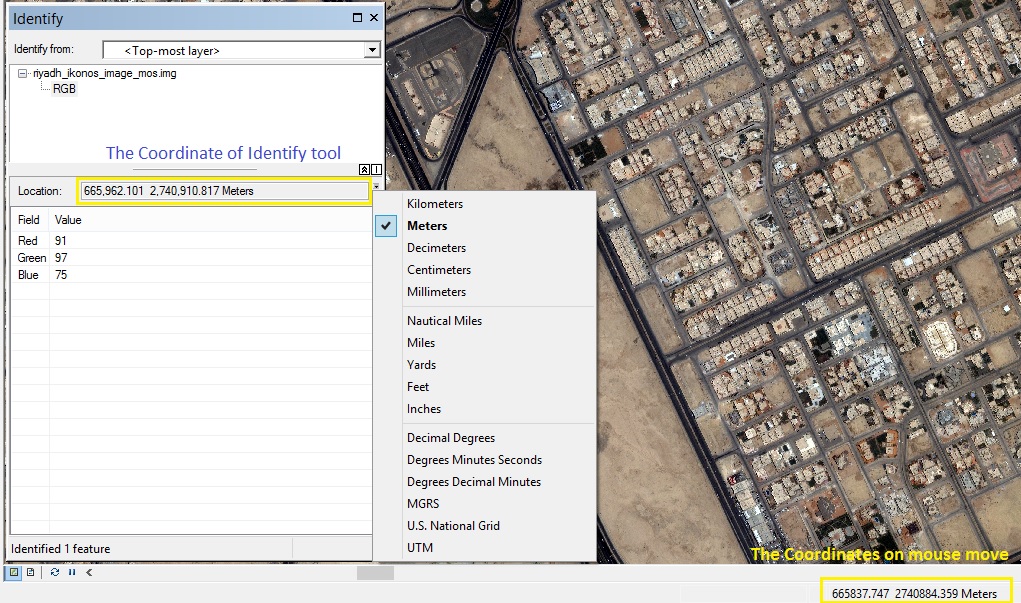
First, for Identify Tool the coordinate of click point show above the attribute table show in Locations rectangle and this is more accurate than coordinate in status bar
Second, The accuracy of Garmin GPS is 3 - 5 meter accuracy and the default coordinate system is Geographic WGS84, That may be not match to the satellite Imagery coordinate system and need to transformation between two coordinate system.
Finally to change the coordinate in attribute table you need to make "Calculate Geometry" by right click the field of X then choose "Calculate Geometry" to update the coordinate you can do that one time after move all points to correct position.
- Mark as New
- Bookmark
- Subscribe
- Mute
- Subscribe to RSS Feed
- Permalink
- Report Inappropriate Content
Hi Mohamed.
Thanks for your suggestion to use the Calculate Geometry function on the coordinate values of my coordinate table to get the correct ones. It solved my problem.
I am aware of the accuracy problem with non-professional GPS receivers (and perhaps with professional ones too, but I don't have one) but my personal experience is that if there is a clear view of the sky and I wait long enough for the GPS unit to lock onto a position, the accuracy is very good. Unfortunately, for this project there was a lot of overhead tree cover that caused problems in getting a good reading.
Ralph
- Mark as New
- Bookmark
- Subscribe
- Mute
- Subscribe to RSS Feed
- Permalink
- Report Inappropriate Content
Hi Ralph,
Open your layer attribute table.
Right click on the field on which you want to calculate the coordinate
Select Calculate Geometry
Use X coordinate or Y coordinate depending on the column for which you are calculating coordinates.
I assume you would like to calculate latitude longitude values, if that is the case use units as Decimal degrees. Longitude will be X coordinate, latitude will be Y coordinate.
- Mark as New
- Bookmark
- Subscribe
- Mute
- Subscribe to RSS Feed
- Permalink
- Report Inappropriate Content
Hi Riyas,
I want to thanks you for your suggestion to use the Calculate Geometry function to get the correct coordinates in my attribute table. It was exactly what I needed. You were very helpful and solved my problem.
Ralph