- Home
- :
- All Communities
- :
- Products
- :
- Geoprocessing
- :
- Geoprocessing Questions
- :
- Convert the projection used by multiple feature cl...
- Subscribe to RSS Feed
- Mark Topic as New
- Mark Topic as Read
- Float this Topic for Current User
- Bookmark
- Subscribe
- Mute
- Printer Friendly Page
Convert the projection used by multiple feature classes in a file geodatabase
- Mark as New
- Bookmark
- Subscribe
- Mute
- Subscribe to RSS Feed
- Permalink
I have a number of file geodatabases containing feature classes using a specific geographic projection.
I wish to convert them all to feature classes in a replacement file geodatabase having a different
geographic projection (for reasons of efficiency). How can I do this?
None of the tools in the standard ArGIS-10.3.1 toolbox (Data Management Tools => Projections and Transformations) don't seem to support it:
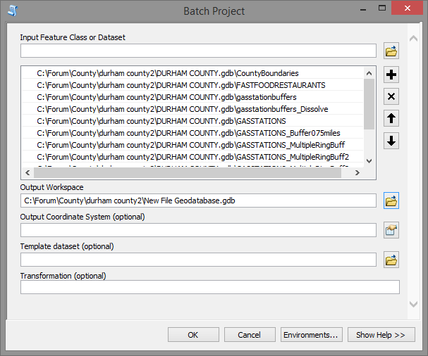
Batch Project only shows files of type "Geographic datasets" and doesn't even display the name of the file geodatabase
Project is for a single dataset only
I have looked at ArcCatalog => Export => To geodatabase (multiple)
but it isn't quite clear to me how to convert the projection.
One can modify the Environments => Output Coordinates
and change the output cooordinate system from "Same as Input" to "As Specified Below"
but it asks for the geographic transformation without providing any guidance
about which one(s) should be used. Batch Project, mentioned above
seems to know which transformation to use since it doesn't ask the user
for that information.
Solved! Go to Solution.
Accepted Solutions
- Mark as New
- Bookmark
- Subscribe
- Mute
- Subscribe to RSS Feed
- Permalink
The Batch project tool allows you to select all the featureclasses inside a file geodatabase and output to another file geodatabase. Are you sure it doesn't work?
- Mark as New
- Bookmark
- Subscribe
- Mute
- Subscribe to RSS Feed
- Permalink
The Batch project tool allows you to select all the featureclasses inside a file geodatabase and output to another file geodatabase. Are you sure it doesn't work?
- Mark as New
- Bookmark
- Subscribe
- Mute
- Subscribe to RSS Feed
- Permalink
You can also run the Project tool in batch mode (right-click Project tool -> Batch...), which, confusingly, is different from Batch Project. Word has it, Project in batch mode is more stable than Batch Project, anyhow.
To your point of having multiple geodatabases, you're going to have to tackle this with Python or ModelBuilder if you want to fully automate the whole thing.
- Mark as New
- Bookmark
- Subscribe
- Mute
- Subscribe to RSS Feed
- Permalink
although Melita Kennedy didn't specifically indicate which version the comment applied to (I you have any update Melita, it would be useful since I found no references on the version changes) (know limitations links for 10.3.ish What's new in ArcGIS 10.3.1 for Desktop—Help | ArcGIS for Desktop and Pro Release notes—ArcGIS Pro | ArcGIS for Desktop
- Mark as New
- Bookmark
- Subscribe
- Mute
- Subscribe to RSS Feed
- Permalink
As far as I know, my comment applies to all versions of the Batch Project tool. It's posslble that it's been fixed. GP handles their own stuff; sometimes I know about it, sometimes I don't.
- Mark as New
- Bookmark
- Subscribe
- Mute
- Subscribe to RSS Feed
- Permalink
I cannot now replicate the problem I had with Batch Project.
I am reluctantly obliged to acknowledge that I must have made some kind of error.
The comments made by Xander, Melita, and Dan are correct.
Still, I am not completely convinced that all is fragrant in the State of Denmark.
I had a file geodatabase on an external hard drive. I am sure I tried more
than once using Batch Project to list the feature classes so I could select
them all. Batch Project saw the file geodatabase, but displayed no feature
classes within it.
Today, I am doing the same thing and now the feature classes are showing up.
I apologise to anyone who wasted time reading my original post, and my thanks to
everyone who responded.
Rob Stevens