- Home
- :
- All Communities
- :
- Products
- :
- Geoprocessing
- :
- Geoprocessing Questions
- :
- Calculate Geometry in batch
- Subscribe to RSS Feed
- Mark Topic as New
- Mark Topic as Read
- Float this Topic for Current User
- Bookmark
- Subscribe
- Mute
- Printer Friendly Page
- Mark as New
- Bookmark
- Subscribe
- Mute
- Subscribe to RSS Feed
- Permalink
Hello,
In order to get my feature data ready for Tableau integration, I had to run 'Feature Vertices to Points' for 28 polygon classes. Then I ran 'Add XY coordinates' for the 28 to get coordinates (which Tableau requires). Problem is, Add XY gave me projected meter values, yet Tableau requires decimal degrees Lat/Long. Instead of recalculating the geometry by going into each of the 28 attribute tables, is there a way to batch recalculate into decimal degrees?
Solved! Go to Solution.
Accepted Solutions
- Mark as New
- Bookmark
- Subscribe
- Mute
- Subscribe to RSS Feed
- Permalink
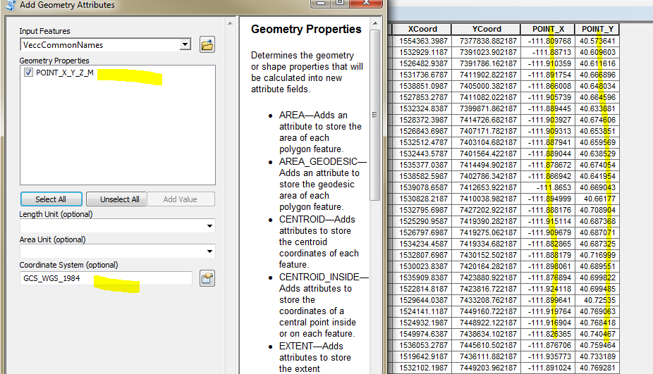
I just tried the Add Geometry Attributes tool on an existing set of points that already had X/Y coords in StatePlane Feet. I selected only the Point_X_Y_Z_M property and gave it the GCS_WGS_1984 coordinate system, and it added two columns in DD. See below:
- Mark as New
- Bookmark
- Subscribe
- Mute
- Subscribe to RSS Feed
- Permalink
Not sure if the below helps.
Calculating geometry using pyscripting: failed to read polygon input feature
I think by the time you develop a script you will probably be able to go in to each feature class and do it yourself. If there were hundred or more then that is different.
Solomon Pulapkura
- Mark as New
- Bookmark
- Subscribe
- Mute
- Subscribe to RSS Feed
- Permalink
I just tried the Add Geometry Attributes tool on an existing set of points that already had X/Y coords in StatePlane Feet. I selected only the Point_X_Y_Z_M property and gave it the GCS_WGS_1984 coordinate system, and it added two columns in DD. See below:
- Mark as New
- Bookmark
- Subscribe
- Mute
- Subscribe to RSS Feed
- Permalink
Yes, that did it! Tested it on 2 then batched the remaining 26. It even overwrote the original PointX & PointY fields made by Add XY Coordinates. Thanks, mate.