- Home
- :
- All Communities
- :
- Products
- :
- Geoprocessing
- :
- Geoprocessing Questions
- :
- ArcPro2.1 Apply Symbology From Layer tool error: a...
- Subscribe to RSS Feed
- Mark Topic as New
- Mark Topic as Read
- Float this Topic for Current User
- Bookmark
- Subscribe
- Mute
- Printer Friendly Page
ArcPro2.1 Apply Symbology From Layer tool error: arguement "Update Symbology Ranges by Data" not working
- Mark as New
- Bookmark
- Subscribe
- Mute
- Subscribe to RSS Feed
- Permalink
Hi all,
Think I've found a bug ![]()
To my understanding this arguement should recalculate my quantiles based on the new data, but it just uses the same classes from the source Symbology Layer.
Here are my inputs:
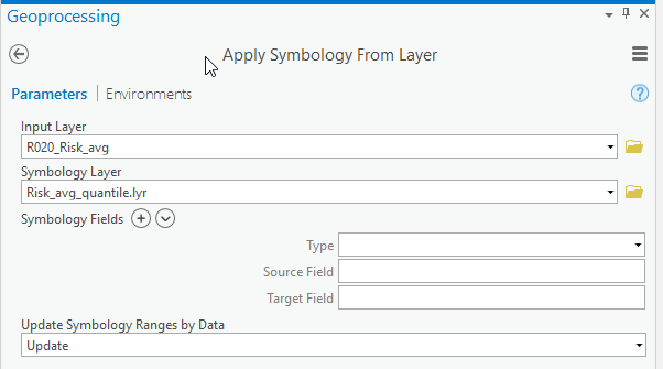
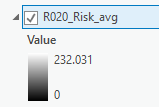
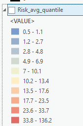
Once I've run the tool as per above, here are results:
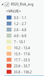
Note, exactly the same break points... not what it is supposed to do... which is"
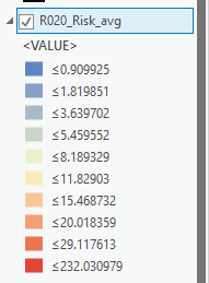
Anyone got ideas? Thanks.
- Mark as New
- Bookmark
- Subscribe
- Mute
- Subscribe to RSS Feed
- Permalink
from here http://pro.arcgis.com/en/pro-app/tool-reference/data-management/apply-symbology-from-layer.htm
although indicated as optional, are your symbology_fields matched? because if they aren't then I don't think anything will update
- Mark as New
- Bookmark
- Subscribe
- Mute
- Subscribe to RSS Feed
- Permalink
Hi Dan,
Thanks for that idea. I tried this, but it didn't work... still not updating the quantiles.
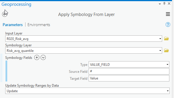
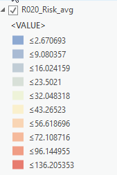
- Mark as New
- Bookmark
- Subscribe
- Mute
- Subscribe to RSS Feed
- Permalink
hmmm, this ... from the link... suggests otherwise, but I have nothing to test with, nor can I find a bug notice.
You can choose to maintain or update the symbology via the Update Symbology Ranges by Data parameter, or leave the default. By default, symbology methods can be dynamic; for example, the symbology is updated to reflect the characteristics of the input layer as shown below. The five-class Natural Breaks classification method from the symbology layer is applied to the input layer, and the range values are updated to reflect the Shape_Area values of the input layer.
- Mark as New
- Bookmark
- Subscribe
- Mute
- Subscribe to RSS Feed
- Permalink
HI Dan,
I've managed to attach my .lyrx file but can't attach my rasters - it keep saying they are too big, but they're tiny!

Not sure what the go is there.
Anyway, Raster 1 has min value 0, max value 136
Raster 2 has min value 0, max value 232
Doesn't seem to matter if it's quantile or natural breaks, it won't update to reflect underlaying data.
Cheers
Erin
- Mark as New
- Bookmark
- Subscribe
- Mute
- Subscribe to RSS Feed
- Permalink
you have to 'zip' stuff in order to attach
- Mark as New
- Bookmark
- Subscribe
- Mute
- Subscribe to RSS Feed
- Permalink
thanks Dan, just did that now!
- Mark as New
- Bookmark
- Subscribe
- Mute
- Subscribe to RSS Feed
- Permalink
Seems even though you had statistics for the images, the legend's symbology needs to be recalculated
In pictures.


- Mark as New
- Bookmark
- Subscribe
- Mute
- Subscribe to RSS Feed
- Permalink
THanks Dan,
I was aware I could do that, so I guess my question really is shouldn't the tool be updating the ranges for me?
I need to create and save these layers automatically, I didn't want to have to open and manually update each one...
Help for tool says:
"You can choose to maintain or update the symbology via the Update Symbology Ranges by Data parameter, or leave the default."
"Classified value rendering to a raster
- The range values are updated to reflect the values of the input layer"
Am I wrong in my interpretation?
Cheers
Erin
- Mark as New
- Bookmark
- Subscribe
- Mute
- Subscribe to RSS Feed
- Permalink
I am not sure that the interpretation is wrong... since it doesn't automagically update. Perhaps that is a 'code' thing for scripting, but it sure doesn't work when you apply the symbology as we did since the recalculate had to be applied... hardly magical... so this might be a question for the Pro Pros...
off to you KKramer-esristaff have we misinterpreted? Is this a bug? or just not a fully implemented as expected description?