- Home
- :
- All Communities
- :
- Products
- :
- Geoprocessing
- :
- Geoprocessing Questions
- :
- Any suggestions on how I might use planarize over ...
- Subscribe to RSS Feed
- Mark Topic as New
- Mark Topic as Read
- Float this Topic for Current User
- Bookmark
- Subscribe
- Mute
- Printer Friendly Page
Any suggestions on how I might use planarize over a large area? I am trying to create fine scale 'road' network off the coast of Australia for tagged fish studies.
- Mark as New
- Bookmark
- Subscribe
- Mute
- Subscribe to RSS Feed
- Permalink
Hi,
I have a situation where I am attempting to create a 'road' network off of the coast of Eastern Australia to analyse tagged fish movements in ArcGIS Pro's Network Analyst, and create an animation of movements where tracks do not move over land.
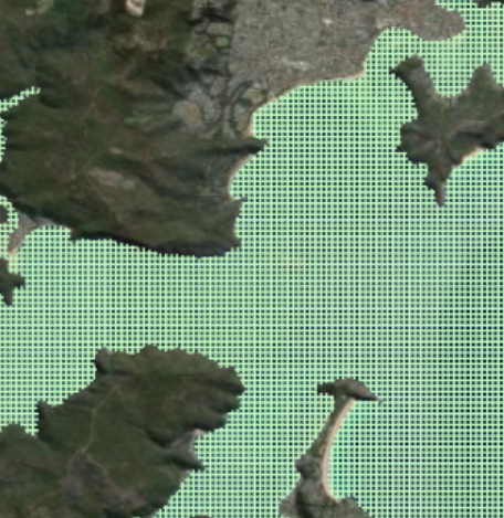
I have created a fish net feature class with a cell width and height of 0.001 which has been clipped to exclude the land mass (so that routing avoids land). Below screenshot is of a small area of the total coastline, but shows how fine scale I am after. I need the lines to be split at the vertices so that when I create a route for the tagged animal the track avoids land. However, when I try to planarize the geoprocess takes way too long... I have had to cancel it after running for over 4 days without it finishing.

I have tried the split line at vertices option also, without any luck.
Any suggestions would be greatly appreciated!
Warm regards,
Alex
Current Geospatial system setup


- Mark as New
- Bookmark
- Subscribe
- Mute
- Subscribe to RSS Feed
- Permalink
You say cell size was set to 0.001, what units are they in, surely not metres, that's 1mm! I highly doubt you are tracking fish movement at 1mm!
How many polygons do you actually have?
Also if you have billions of polygons and even if you converted them into lines which could be used to construct a network, you'll likely end up with a "road network" more complex than all the roads in the world and then some... Not sure even the mighty ArcPro could handle that....
- Mark as New
- Bookmark
- Subscribe
- Mute
- Subscribe to RSS Feed
- Permalink
Hi Duncan,
Thank you for getting back to me, and to Leslie for drawing attention to my question on the forum!
The 'Create Fishnet' tool doesn't allow for the allocation of units prior to running the tool, and just lets you choose a cell size width and height (which I have picked as 0.001). I trialled out a small area for this and it created cell dimensions of 100m x 100m.
Since posting, I have figured out a simple solution to my problem. Initially I created a fishnet as a polyline, which seemed to be causing my problems. I was definitely over thinking the problem ![]() .
.
I will outline my solution:
1) Create a fishnet as a polygon rather than a polyline
2) Convert polygon to line by ignoring neighbouring polygon information
3) Split line at vertices.
4) Bingo - the whole process for a large dataset (with 167,979,456 individual segments) such as this was cut down to around 40 mins.
I also found that I can use 'Generate Tessellation' to introduce polygons with diagonal paths within my AOI. Then I followed the above points 2 and 3 to achieve the same output. I discovered that the route output with square cells was not a very sensible path for the fish to be taking, so introduced the diagonal paths in the form of diamonds, triangles, and hexagons (just to see how the software's output behaved). Triangles are the way to go, and provide a more sensible route along a coastline!