Turn on suggestions
Auto-suggest helps you quickly narrow down your search results by suggesting possible matches as you type.
Cancel
- Home
- :
- All Communities
- :
- Products
- :
- Geoprocessing
- :
- Geoprocessing Questions
- :
- Adding Together Rasters
Options
- Subscribe to RSS Feed
- Mark Topic as New
- Mark Topic as Read
- Float this Topic for Current User
- Bookmark
- Subscribe
- Mute
- Printer Friendly Page
Adding Together Rasters
Subscribe
2009
4
07-20-2010 05:41 AM
by
Anonymous User
Not applicable
07-20-2010
05:41 AM
- Mark as New
- Bookmark
- Subscribe
- Mute
- Subscribe to RSS Feed
- Permalink
Original User: Kenyon07
Hi,
I am trying to add together a bunch or rasters (about 300), and I know of no way other than using the raster calculater to do this. (Ex. [RASHFT0.tif] + [RASHFT0.tif] + [RASHFT0.tif] )
But this seems not to work. How can I truely add together all of these rasters?
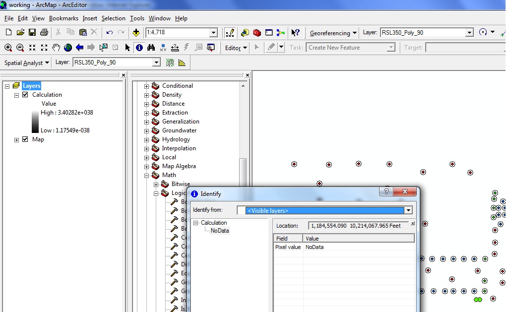
Attached is a text file that I put the values into the raster calculator to do the calculation (Adding.txt) and also a picture of my screen(Calculation.jpg). The calculation shows values in the TOC but returns NoData.
Hi,
I am trying to add together a bunch or rasters (about 300), and I know of no way other than using the raster calculater to do this. (Ex. [RASHFT0.tif] + [RASHFT0.tif] + [RASHFT0.tif] )
But this seems not to work. How can I truely add together all of these rasters?
Attached is a text file that I put the values into the raster calculator to do the calculation (Adding.txt) and also a picture of my screen(Calculation.jpg). The calculation shows values in the TOC but returns NoData.
4 Replies
07-20-2010
01:07 PM
- Mark as New
- Bookmark
- Subscribe
- Mute
- Subscribe to RSS Feed
- Permalink
Bump. Anybody?
by
Anonymous User
Not applicable
07-20-2010
01:50 PM
- Mark as New
- Bookmark
- Subscribe
- Mute
- Subscribe to RSS Feed
- Permalink
Original User: csny490
For the addition to work (or pretty much any other raster math), your rasters must have the same spatial extent. So basically (I assume these are the light poles) for each raster you need to create a new raster where the NoData within your study area is 0 (or some other non NoData value). Here's some Python code that might give you some ideas:
#
# Description
# -----------
# This script will mosaic a binch of grids, but using a secret method that is
# mucho faster than the standard v9.3.1 SP1 mosaic tool.
#
# Written By: Chris Snyder, WA DNR, 03/01/2010, chris.snyder(at)wadnr.gov
#
# Written For: Python 2.5.1 and ArcGIS v9.3.1 SP1
#
# UPDATES:
#
# Notes on input parameters (for the toolbox):
# VARIABLE PAREMETER_INDEX PARAMETER_DATA_TYPE
# -------------------------------------------------------------------
# gridList 0 Grids
# outputGrid 1 Grid
# tempWorkspace 2 Workspace
# mosaicMethod 3 String (MAX, MIN, or MEAN)
# tempNoDataValue 4 Long Integer
try:
#Process: Import some modules
import os, string, sys, time, traceback, arcgisscripting
#Process: Create the gp object
gp = arcgisscripting.create(9.3)
#Process: Defines some functions used for getting messages from the gp and python
def showGpMessage():
gp.AddMessage(gp.GetMessages())
print >> open(logFile, 'a'), gp.GetMessages()
print gp.GetMessages()
def showGpWarning():
gp.AddWarning(gp.GetMessages())
print >> open(logFile, 'a'), gp.GetMessages()
print gp.GetMessages()
def showGpError():
gp.AddError(gp.GetMessages())
print >> open(logFile, 'a'), gp.GetMessages()
print gp.GetMessages()
def showPyLog(): #just print to the log file!
print >> open(logFile, 'a'), str(time.ctime()) + " - " + message
def showPyMessage():
gp.AddMessage(str(time.ctime()) + " - " + message)
print >> open(logFile, 'a'), str(time.ctime()) + " - " + message
print str(time.ctime()) + " - " + message
def showPyWarning():
gp.AddWarning(str(time.ctime()) + " - " + message)
print >> open(logFile, 'a'), str(time.ctime()) + " - " + message
print str(time.ctime()) + " - " + message
def showPyError():
gp.AddError(str(time.ctime()) + " - " + message)
print >> open(logFile, 'a'), str(time.ctime()) + " - " + message
print str(time.ctime()) + " - " + message
#Specifies the root directory variable, defines the logFile variable, and does some minor error checking...
dateTimeString = str(time.strftime('%Y%m%d%H%M%S'))
scriptName = os.path.split(sys.argv[0])[-1].split(".")[0]
userName = string.lower(os.environ.get("USERNAME")).replace(" ","_").replace(".","_")
tempPathDir = os.environ["TEMP"]
logFileDirectory = r"\\snarf\am\div_lm\ds\gis\tools\log_files"
if os.path.exists(logFileDirectory) == True:
logFile = os.path.join(logFileDirectory, scriptName + "_" + userName + "_" + dateTimeString + ".txt")
try:
print >> open(logFile, 'a'), "Write test successfull!"
except:
logFile = os.path.join(tempPathDir, scriptName + "_" + userName + "_" + dateTimeString + ".txt")
else:
logFile = os.path.join(tempPathDir, scriptName + "_" + userName + "_" + dateTimeString + ".txt")
if os.path.exists(logFile)== True:
os.remove(logFile)
message = "Created log file " + logFile; showPyMessage()
message = "Running " + sys.argv[0]; showPyMessage()
#Process: Attempts to check out a Spatial Analyst license
try:
gp.CheckOutExtension("Spatial")
except:
message = "ERROR: Spatial analyst license is unavailable... Exiting script!"; showPyError(); sys.exit()
#Process: Check out the highest license available
try:
if gp.CheckProduct("ArcView") == "Available":
gp.SetProduct("ArcView")
elif gp.CheckProduct("ArcEditor") == "Available":
gp.SetProduct("ArcEditor")
elif gp.CheckProduct("ArcInfo") == "Available":
gp.SetProduct("ArcInfo")
except:
message = "ERROR: Could not select an ArcGIS license level! Exiting script..."; showPyError(); sys.exit()
message = "Selected an " + gp.ProductInfo() + " license"; showPyMessage()
#Process: Sets some gp environment variables
gp.overwriteoutput = True
gp.pyramid = "NONE"
gp.rasterStatistics = "NONE"
#Process: Collect the input parameters
## gridList = r"D:\csny490\usgs_dem10m\dem11746;D:\csny490\usgs_dem10m\dem11747"
## outputGrid = r"D:\csny490\temp\temp\howaboutthis"
## processingWorkspace = r"D:\csny490\temp\temp"
## mosaicMethod = "MAX"
## tempNoDataValue = "-32000"
gridList = gp.GetParameterAsText(0)
outputGrid = gp.GetParameterAsText(1)
processingWorkspace = gp.GetParameterAsText(2)
mosaicMethod = gp.GetParameterAsText(3)
tempNoDataValue = gp.GetParameterAsText(4)
#Process: Print out the input parameters
message = "INPUT PARAMETERS"; showPyMessage()
message = "----------------"; showPyMessage()
message = "Input Grids = " + gridList; showPyMessage()
message = "Output Grid = " + outputGrid; showPyMessage()
message = "Processing Workspace = " + processingWorkspace; showPyMessage()
message = "Mosaic Method = " + mosaicMethod; showPyMessage()
message = "Temp NoData Value = " + tempNoDataValue + "\n"; showPyMessage()
#Process: Figure out the maximum extent of all the input grids
message = "Calculating maximum extent of input rasters..."; showPyMessage()
i = 0
gridsToProcessList = gridList.split(";")
for grid in gridsToProcessList:
i = i + 1
dsc = gp.describe(grid)
if i == 1:
xMin = dsc.extent.xmin
yMin = dsc.extent.ymin
xMax = dsc.extent.xmax
yMax = dsc.extent.ymax
else:
if dsc.extent.xmin < xMin:
xMin = dsc.extent.xmin
if dsc.extent.xmax > xMax:
xMax = dsc.extent.xmax
if dsc.extent.ymin < yMin:
yMin = dsc.extent.ymin
if dsc.extent.ymax > yMax:
yMax = dsc.extent.ymax
gp.extent = str(xMin) + " " + str(yMin) + " " + str(xMax) + " " + str(yMax)
message = "Maximum extent of input rasters is " + str(gp.extent) + "..."; showPyMessage()
#Process: Now build some new grids that have the max extent
maxString = ""
tempGridList = []
i = 0
tempGridDict = {}
for grid in gridsToProcessList:
i = i + 1
message = "Normalizing extent of " + grid + "..."; showPyMessage()
dsc = gp.describe(grid)
if dsc.format != "GRID": #if it aint a grid, make it one
tempConvertGrid = gp.createscratchname("","","RASTER",processingWorkspace)
gp.extent = ""
gp.CopyRaster_management(grid, tempConvertGrid, "", "", "", "", "", "")
tempGridList.append(tempConvertGrid)
somaExp = "con(isnull(" + tempConvertGrid + "), " + str(tempNoDataValue) + ", " + tempConvertGrid + ")"
else:
somaExp = "con(isnull(" + grid + "), " + str(tempNoDataValue) + ", " + grid + ")"
tempGrid = gp.createscratchname("","","RASTER", processingWorkspace)
tempGridList.append(tempGrid)
maxString = maxString + tempGrid + ","
gp.extent = str(xMin) + " " + str(yMin) + " " + str(xMax) + " " + str(yMax)
gp.SingleOutputMapAlgebra_sa(somaExp, tempGrid)
#Process: Max, then put back to null
message = "Mosaicing - This will take a while..."; showPyMessage()
tempGrid = gp.createscratchname("","","RASTER",processingWorkspace)
tempGridList.append(tempGrid)
if mosaicMethod == "MIN":
somaExp = "min(" + maxString + ")"
if mosaicMethod == "MAX":
somaExp = "max(" + maxString + ")"
if mosaicMethod == "MEAN":
somaExp = "mean(" + maxString + ")"
gp.SingleOutputMapAlgebra_sa(somaExp, tempGrid)
somaExp = somaExp = "con(" + tempGrid + " == " + str(tempNoDataValue) + ", setnull(1), " + tempGrid + ")"
if outputGrid.split(".")[-1] in (".bmp",".gif",".img",".jpg",".jp2",".png",".tif") or\
".gdb" in outputGrid or ".mdb" in outputGrid or ".sde" in outputGrid:
tempMosaicGrid = gp.createscratchname("","","RASTER", processingWorkspace)
tempGridList.append(tempMosaicGrid)
gp.SingleOutputMapAlgebra_sa(somaExp, tempMosaicGrid)
gp.CopyRaster_management(tempMosaicGrid, outputGrid, "", "", "", "", "", "")
else:
gp.SingleOutputMapAlgebra_sa(somaExp, outputGrid)
#Process: Delete all the temp grids
message = "Removing temporay processing grids..."; showPyMessage()
for tempGrid in tempGridList:
try:
gp.Delete_management(tempGrid, "")
except:
message = "WARNING: Failed to delete processing grid " + str(tempGrid) + "..."; showPyWarning()
message = "All done!"; showPyMessage()
except:
message = "\n*** PYTHON ERRORS *** "; showPyMessage()
message = "Python Traceback Info: " + traceback.format_tb(sys.exc_info()[2])[0]; showPyMessage()
message = "Python Error Info: " + str(sys.exc_type)+ ": " + str(sys.exc_value) + "\n"; showPyMessage()
For the addition to work (or pretty much any other raster math), your rasters must have the same spatial extent. So basically (I assume these are the light poles) for each raster you need to create a new raster where the NoData within your study area is 0 (or some other non NoData value). Here's some Python code that might give you some ideas:
# Name: make_fast_mosaic_v93.py
#
# Description
# -----------
# This script will mosaic a binch of grids, but using a secret method that is
# mucho faster than the standard v9.3.1 SP1 mosaic tool.
#
# Written By: Chris Snyder, WA DNR, 03/01/2010, chris.snyder(at)wadnr.gov
#
# Written For: Python 2.5.1 and ArcGIS v9.3.1 SP1
#
# UPDATES:
#
# Notes on input parameters (for the toolbox):
# VARIABLE PAREMETER_INDEX PARAMETER_DATA_TYPE
# -------------------------------------------------------------------
# gridList 0 Grids
# outputGrid 1 Grid
# tempWorkspace 2 Workspace
# mosaicMethod 3 String (MAX, MIN, or MEAN)
# tempNoDataValue 4 Long Integer
try:
#Process: Import some modules
import os, string, sys, time, traceback, arcgisscripting
#Process: Create the gp object
gp = arcgisscripting.create(9.3)
#Process: Defines some functions used for getting messages from the gp and python
def showGpMessage():
gp.AddMessage(gp.GetMessages())
print >> open(logFile, 'a'), gp.GetMessages()
print gp.GetMessages()
def showGpWarning():
gp.AddWarning(gp.GetMessages())
print >> open(logFile, 'a'), gp.GetMessages()
print gp.GetMessages()
def showGpError():
gp.AddError(gp.GetMessages())
print >> open(logFile, 'a'), gp.GetMessages()
print gp.GetMessages()
def showPyLog(): #just print to the log file!
print >> open(logFile, 'a'), str(time.ctime()) + " - " + message
def showPyMessage():
gp.AddMessage(str(time.ctime()) + " - " + message)
print >> open(logFile, 'a'), str(time.ctime()) + " - " + message
print str(time.ctime()) + " - " + message
def showPyWarning():
gp.AddWarning(str(time.ctime()) + " - " + message)
print >> open(logFile, 'a'), str(time.ctime()) + " - " + message
print str(time.ctime()) + " - " + message
def showPyError():
gp.AddError(str(time.ctime()) + " - " + message)
print >> open(logFile, 'a'), str(time.ctime()) + " - " + message
print str(time.ctime()) + " - " + message
#Specifies the root directory variable, defines the logFile variable, and does some minor error checking...
dateTimeString = str(time.strftime('%Y%m%d%H%M%S'))
scriptName = os.path.split(sys.argv[0])[-1].split(".")[0]
userName = string.lower(os.environ.get("USERNAME")).replace(" ","_").replace(".","_")
tempPathDir = os.environ["TEMP"]
logFileDirectory = r"\\snarf\am\div_lm\ds\gis\tools\log_files"
if os.path.exists(logFileDirectory) == True:
logFile = os.path.join(logFileDirectory, scriptName + "_" + userName + "_" + dateTimeString + ".txt")
try:
print >> open(logFile, 'a'), "Write test successfull!"
except:
logFile = os.path.join(tempPathDir, scriptName + "_" + userName + "_" + dateTimeString + ".txt")
else:
logFile = os.path.join(tempPathDir, scriptName + "_" + userName + "_" + dateTimeString + ".txt")
if os.path.exists(logFile)== True:
os.remove(logFile)
message = "Created log file " + logFile; showPyMessage()
message = "Running " + sys.argv[0]; showPyMessage()
#Process: Attempts to check out a Spatial Analyst license
try:
gp.CheckOutExtension("Spatial")
except:
message = "ERROR: Spatial analyst license is unavailable... Exiting script!"; showPyError(); sys.exit()
#Process: Check out the highest license available
try:
if gp.CheckProduct("ArcView") == "Available":
gp.SetProduct("ArcView")
elif gp.CheckProduct("ArcEditor") == "Available":
gp.SetProduct("ArcEditor")
elif gp.CheckProduct("ArcInfo") == "Available":
gp.SetProduct("ArcInfo")
except:
message = "ERROR: Could not select an ArcGIS license level! Exiting script..."; showPyError(); sys.exit()
message = "Selected an " + gp.ProductInfo() + " license"; showPyMessage()
#Process: Sets some gp environment variables
gp.overwriteoutput = True
gp.pyramid = "NONE"
gp.rasterStatistics = "NONE"
#Process: Collect the input parameters
## gridList = r"D:\csny490\usgs_dem10m\dem11746;D:\csny490\usgs_dem10m\dem11747"
## outputGrid = r"D:\csny490\temp\temp\howaboutthis"
## processingWorkspace = r"D:\csny490\temp\temp"
## mosaicMethod = "MAX"
## tempNoDataValue = "-32000"
gridList = gp.GetParameterAsText(0)
outputGrid = gp.GetParameterAsText(1)
processingWorkspace = gp.GetParameterAsText(2)
mosaicMethod = gp.GetParameterAsText(3)
tempNoDataValue = gp.GetParameterAsText(4)
#Process: Print out the input parameters
message = "INPUT PARAMETERS"; showPyMessage()
message = "----------------"; showPyMessage()
message = "Input Grids = " + gridList; showPyMessage()
message = "Output Grid = " + outputGrid; showPyMessage()
message = "Processing Workspace = " + processingWorkspace; showPyMessage()
message = "Mosaic Method = " + mosaicMethod; showPyMessage()
message = "Temp NoData Value = " + tempNoDataValue + "\n"; showPyMessage()
#Process: Figure out the maximum extent of all the input grids
message = "Calculating maximum extent of input rasters..."; showPyMessage()
i = 0
gridsToProcessList = gridList.split(";")
for grid in gridsToProcessList:
i = i + 1
dsc = gp.describe(grid)
if i == 1:
xMin = dsc.extent.xmin
yMin = dsc.extent.ymin
xMax = dsc.extent.xmax
yMax = dsc.extent.ymax
else:
if dsc.extent.xmin < xMin:
xMin = dsc.extent.xmin
if dsc.extent.xmax > xMax:
xMax = dsc.extent.xmax
if dsc.extent.ymin < yMin:
yMin = dsc.extent.ymin
if dsc.extent.ymax > yMax:
yMax = dsc.extent.ymax
gp.extent = str(xMin) + " " + str(yMin) + " " + str(xMax) + " " + str(yMax)
message = "Maximum extent of input rasters is " + str(gp.extent) + "..."; showPyMessage()
#Process: Now build some new grids that have the max extent
maxString = ""
tempGridList = []
i = 0
tempGridDict = {}
for grid in gridsToProcessList:
i = i + 1
message = "Normalizing extent of " + grid + "..."; showPyMessage()
dsc = gp.describe(grid)
if dsc.format != "GRID": #if it aint a grid, make it one
tempConvertGrid = gp.createscratchname("","","RASTER",processingWorkspace)
gp.extent = ""
gp.CopyRaster_management(grid, tempConvertGrid, "", "", "", "", "", "")
tempGridList.append(tempConvertGrid)
somaExp = "con(isnull(" + tempConvertGrid + "), " + str(tempNoDataValue) + ", " + tempConvertGrid + ")"
else:
somaExp = "con(isnull(" + grid + "), " + str(tempNoDataValue) + ", " + grid + ")"
tempGrid = gp.createscratchname("","","RASTER", processingWorkspace)
tempGridList.append(tempGrid)
maxString = maxString + tempGrid + ","
gp.extent = str(xMin) + " " + str(yMin) + " " + str(xMax) + " " + str(yMax)
gp.SingleOutputMapAlgebra_sa(somaExp, tempGrid)
#Process: Max, then put back to null
message = "Mosaicing - This will take a while..."; showPyMessage()
tempGrid = gp.createscratchname("","","RASTER",processingWorkspace)
tempGridList.append(tempGrid)
if mosaicMethod == "MIN":
somaExp = "min(" + maxString + ")"
if mosaicMethod == "MAX":
somaExp = "max(" + maxString + ")"
if mosaicMethod == "MEAN":
somaExp = "mean(" + maxString + ")"
gp.SingleOutputMapAlgebra_sa(somaExp, tempGrid)
somaExp = somaExp = "con(" + tempGrid + " == " + str(tempNoDataValue) + ", setnull(1), " + tempGrid + ")"
if outputGrid.split(".")[-1] in (".bmp",".gif",".img",".jpg",".jp2",".png",".tif") or\
".gdb" in outputGrid or ".mdb" in outputGrid or ".sde" in outputGrid:
tempMosaicGrid = gp.createscratchname("","","RASTER", processingWorkspace)
tempGridList.append(tempMosaicGrid)
gp.SingleOutputMapAlgebra_sa(somaExp, tempMosaicGrid)
gp.CopyRaster_management(tempMosaicGrid, outputGrid, "", "", "", "", "", "")
else:
gp.SingleOutputMapAlgebra_sa(somaExp, outputGrid)
#Process: Delete all the temp grids
message = "Removing temporay processing grids..."; showPyMessage()
for tempGrid in tempGridList:
try:
gp.Delete_management(tempGrid, "")
except:
message = "WARNING: Failed to delete processing grid " + str(tempGrid) + "..."; showPyWarning()
message = "All done!"; showPyMessage()
except:
message = "\n*** PYTHON ERRORS *** "; showPyMessage()
message = "Python Traceback Info: " + traceback.format_tb(sys.exc_info()[2])[0]; showPyMessage()
message = "Python Error Info: " + str(sys.exc_type)+ ": " + str(sys.exc_value) + "\n"; showPyMessage()
07-20-2010
01:53 PM
- Mark as New
- Bookmark
- Subscribe
- Mute
- Subscribe to RSS Feed
- Permalink
For the addition to work (or pretty much any other raster math), your rasters must have the same spatial extent. So basically (I assume these are the light poles) for each raster you need to create a new raster where the NoData within your study area is 0 (or some other non NoData value). Here's some Python code that might give you some ideas:
# Name: make_fast_mosaic_v93.py
#
# Description
# -----------
# This script will mosaic a bunch of grids, but using a secret method that is
# mucho faster than the standard v9.3.1 SP1 mosaic tool.
#
# Written By: Chris Snyder, WA DNR, 03/01/2010, chris.snyder(at)wadnr.gov
#
# Written For: Python 2.5.1 and ArcGIS v9.3.1 SP1
#
# UPDATES:
#
# Notes on input parameters (for the toolbox):
# VARIABLE             PAREMETER_INDEX     PARAMETER_DATA_TYPE
# -------------------------------------------------------------------
# gridList             0                   Grids
# outputGrid           1                   Grid
# tempWorkspace        2                   Workspace
# mosaicMethod         3                   String (MAX, MIN, or MEAN)
# tempNoDataValue      4                   Long Integer

try:
    #Process: Import some modules
    import os, string, sys, time, traceback, arcgisscripting

    #Process: Create the gp object
    gp = arcgisscripting.create(9.3)

    #Process: Defines some functions used for getting messages from the gp and python
    def showGpMessage():
        gp.AddMessage(gp.GetMessages())
        print >> open(logFile, 'a'), gp.GetMessages()
        print gp.GetMessages()
    def showGpWarning():
        gp.AddWarning(gp.GetMessages())
        print >> open(logFile, 'a'), gp.GetMessages()
        print gp.GetMessages()
    def showGpError():
        gp.AddError(gp.GetMessages())
        print >> open(logFile, 'a'), gp.GetMessages()
        print gp.GetMessages()
    def showPyLog(): #just print to the log file!
        print >> open(logFile, 'a'), str(time.ctime()) + " - " + message
    def showPyMessage():
        gp.AddMessage(str(time.ctime()) + " - " + message)
        print >> open(logFile, 'a'), str(time.ctime()) + " - " + message
        print str(time.ctime()) + " - " + message
    def showPyWarning():
        gp.AddWarning(str(time.ctime()) + " - " + message)
        print >> open(logFile, 'a'), str(time.ctime()) + " - " + message
        print str(time.ctime()) + " - " + message
    def showPyError():
        gp.AddError(str(time.ctime()) + " - " + message)
        print >> open(logFile, 'a'), str(time.ctime()) + " - " + message
        print str(time.ctime()) + " - " + message

    #Specifies the root directory variable, defines the logFile variable, and does some minor error checking...
    dateTimeString = str(time.strftime('%Y%m%d%H%M%S'))
    scriptName = os.path.split(sys.argv[0])[-1].split(".")[0]
    userName = string.lower(os.environ.get("USERNAME")).replace(" ","_").replace(".","_")
    tempPathDir = os.environ["TEMP"]
    logFileDirectory = r"\\snarf\am\div_lm\ds\gis\tools\log_files"
    if os.path.exists(logFileDirectory) == True:
        logFile = os.path.join(logFileDirectory, scriptName + "_" + userName + "_" + dateTimeString + ".txt")
        try:
            print >> open(logFile, 'a'), "Write test successfull!"
        except:
            logFile = os.path.join(tempPathDir, scriptName + "_" + userName + "_" + dateTimeString + ".txt")
    else:
        logFile = os.path.join(tempPathDir, scriptName + "_" + userName + "_" + dateTimeString + ".txt")
    if os.path.exists(logFile)== True:
        os.remove(logFile)
        message = "Created log file " + logFile; showPyMessage()
    message = "Running " + sys.argv[0]; showPyMessage()

    #Process: Attempts to check out a Spatial Analyst license
    try:
        gp.CheckOutExtension("Spatial")
    except:
        message = "ERROR: Spatial analyst license is unavailable... Exiting script!"; showPyError(); sys.exit()

    #Process: Check out the highest license available
    try:
        if gp.CheckProduct("ArcView") == "Available":
            gp.SetProduct("ArcView")
        elif gp.CheckProduct("ArcEditor") == "Available":
            gp.SetProduct("ArcEditor")
        elif gp.CheckProduct("ArcInfo") == "Available":
            gp.SetProduct("ArcInfo")
    except:
        message = "ERROR: Could not select an ArcGIS license level! Exiting script..."; showPyError(); sys.exit()
    message =  "Selected an " + gp.ProductInfo() + " license"; showPyMessage()

    #Process: Sets some gp environment variables
    gp.overwriteoutput = True
    gp.pyramid = "NONE"
    gp.rasterStatistics = "NONE"

    #Process: Collect the input parameters
##    gridList = r"D:\csny490\usgs_dem10m\dem11746;D:\csny490\usgs_dem10m\dem11747"
##    outputGrid = r"D:\csny490\temp\temp\howaboutthis"
##    processingWorkspace = r"D:\csny490\temp\temp"
##    mosaicMethod = "MAX"
##    tempNoDataValue = "-32000"
    gridList = gp.GetParameterAsText(0)
    outputGrid = gp.GetParameterAsText(1)
    processingWorkspace = gp.GetParameterAsText(2)
    mosaicMethod = gp.GetParameterAsText(3)
    tempNoDataValue = gp.GetParameterAsText(4)

    #Process: Print out the input parameters
    message = "INPUT PARAMETERS"; showPyMessage()
    message = "----------------"; showPyMessage()
    message = "Input Grids          = " + gridList; showPyMessage()
    message = "Output Grid          = " + outputGrid; showPyMessage()
    message = "Processing Workspace = " + processingWorkspace; showPyMessage()
    message = "Mosaic Method        = " + mosaicMethod; showPyMessage()
    message = "Temp NoData Value    = " + tempNoDataValue + "\n"; showPyMessage()

    #Process: Figure out the maximum extent of all the input grids
    message = "Calculating maximum extent of input rasters..."; showPyMessage()
    i = 0
    gridsToProcessList = gridList.split(";")
    for grid in gridsToProcessList:
        i = i + 1
        dsc = gp.describe(grid)
        if i == 1:
            xMin = dsc.extent.xmin
            yMin = dsc.extent.ymin
            xMax = dsc.extent.xmax
            yMax = dsc.extent.ymax
        else:
            if dsc.extent.xmin < xMin:
                xMin = dsc.extent.xmin
            if dsc.extent.xmax > xMax:
                xMax = dsc.extent.xmax
            if dsc.extent.ymin < yMin:
                yMin = dsc.extent.ymin
            if dsc.extent.ymax > yMax:
                yMax = dsc.extent.ymax

    gp.extent = str(xMin) + " " + str(yMin) + " " + str(xMax) + " " + str(yMax)
    message = "Maximum extent of input rasters is " + str(gp.extent) + "..."; showPyMessage()

    #Process: Now build some new grids that have the max extent
    maxString = ""
    tempGridList = []
    i = 0
    tempGridDict = {}
    for grid in gridsToProcessList:
        i = i + 1
        message = "Normalizing extent of " + grid + "..."; showPyMessage()
        dsc = gp.describe(grid)
        if dsc.format != "GRID": #if it aint a grid, make it one
            tempConvertGrid = gp.createscratchname("","","RASTER",processingWorkspace)
            gp.extent = ""
            gp.CopyRaster_management(grid, tempConvertGrid, "", "", "", "", "", "")
            tempGridList.append(tempConvertGrid)
            somaExp = "con(isnull(" + tempConvertGrid + "), " + str(tempNoDataValue) + ", " + tempConvertGrid + ")"
        else:
            somaExp = "con(isnull(" + grid + "), " + str(tempNoDataValue) + ", " + grid + ")"
        tempGrid = gp.createscratchname("","","RASTER", processingWorkspace)
        tempGridList.append(tempGrid)
        maxString = maxString + tempGrid + ","
        gp.extent = str(xMin) + " " + str(yMin) + " " + str(xMax) + " " + str(yMax)
        gp.SingleOutputMapAlgebra_sa(somaExp, tempGrid)

    #Process: Max, then put back to null
    message = "Mosaicing - This will take a while..."; showPyMessage()
    tempGrid = gp.createscratchname("","","RASTER",processingWorkspace)
    tempGridList.append(tempGrid)
    if mosaicMethod == "MIN":
        somaExp = "min(" + maxString + ")"
    if mosaicMethod == "MAX":
        somaExp = "max(" + maxString + ")"
    if mosaicMethod == "MEAN":
        somaExp = "mean(" + maxString + ")"
    gp.SingleOutputMapAlgebra_sa(somaExp, tempGrid)
    somaExp = somaExp = "con(" + tempGrid + " == " + str(tempNoDataValue) + ", setnull(1), " + tempGrid + ")"
    if outputGrid.split(".")[-1] in (".bmp",".gif",".img",".jpg",".jp2",".png",".tif") or\
       ".gdb" in outputGrid or ".mdb" in outputGrid or ".sde" in outputGrid:
        tempMosaicGrid = gp.createscratchname("","","RASTER", processingWorkspace)
        tempGridList.append(tempMosaicGrid)
        gp.SingleOutputMapAlgebra_sa(somaExp, tempMosaicGrid)
        gp.CopyRaster_management(tempMosaicGrid, outputGrid, "", "", "", "", "", "")
    else:
        gp.SingleOutputMapAlgebra_sa(somaExp, outputGrid)

    #Process: Delete all the temp grids
    message = "Removing temporay processing grids..."; showPyMessage()
    for tempGrid in tempGridList:
        try:
            gp.Delete_management(tempGrid, "")
        except:
            message = "WARNING: Failed to delete processing grid " + str(tempGrid) + "..."; showPyWarning()

    message = "All done!"; showPyMessage()

except:
    message = "\n*** PYTHON ERRORS *** "; showPyMessage()
    message = "Python Traceback Info: " + traceback.format_tb(sys.exc_info()[2])[0]; showPyMessage()
    message = "Python Error Info: " +  str(sys.exc_type)+ ": " + str(sys.exc_value) + "\n"; showPyMessage()
by
Anonymous User
Not applicable
07-19-2011
07:27 AM
- Mark as New
- Bookmark
- Subscribe
- Mute
- Subscribe to RSS Feed
- Permalink
Original User: susanwitherly
Have you tried adding just a few of your rasters together using the raster calculator? Might give you a sense of whether the problem is an extent issue or a format problem? There might be a limit to how much text the raster calculator can handle. Try using a script such as:
import arcpy
intCount = 0
MainWS = "C:\GISProj\RasterData"
from arcpy import env
from arcpy.sa import *
env.workspace = MainWS
arcpy.CheckOutExtension("Spatial")
print intCount
rasterList = arcpy.ListRasters()
for raster in rasterList:
print raster
if intCount == 0:
output = raster
intCount = intCount + 1
print output
else:
intCount = intCount + 1
output = arcpy.sa.Plus(output, raster)
output.save("C:\GISProj\Workspace\Processing.gdb\output")
print "Total Number of Rasters: " + str(intCount)
Note the loss of indentation in the python code!