GeoMentors Blog - Page 3

cancel
Showing results for 
Show  only  | Search instead for 
Did you mean: 

Latest Activity

(125 Posts)
CandiceLuebbering
Frequent Contributor

The December 2018 GeoMentors newsletter is out (and has been for a little bit, but we were on holiday....)!  View the full issue here..

more
0 0 435
JoleneKeen1
Frequent Contributor

The October 2018 GeoMentors newsletter is out!  View the full issue here.

more
1 0 334
CandiceLuebbering
Frequent Contributor

A GeoMentors Campaign for 2018 Geography Awareness Week and Beyond

Is there a book that inspires you as a geographer? A book that made you more interested and intrigued by geography? Perhaps a go-to text that you refer others to when they want to know more about being a geographer or about your area of research or teaching? If you had to give elementary, middle, or high school students a book to spark their interest in geography, (besides an atlas...) what would it be?

Adding geography to US K-12 schools isn’t just about finding ways to teach more geography directly in classrooms. It’s also about ways, big and small, to encourage students, or even just one student, to explore what geography has to offer and how it can help them understand their world. It can be about simply making more geography resources available for students to discover.

For GAW 2018, we encourage and challenge GeoMentors and geographers across the country to donate 1 geography book to a school or public library in your community.

Think outside the box, or perhaps we should say...outside the atlas. These don’t have to just be geography textbooks or even books that are overtly about the discipline of geography (geography doesn’t have to be in the title). Our discipline is diverse and many books are geographic in different ways - so be creative in thinking of books that excite you and ones that may also excite students!

Yes, I’m in! Now, how should I go about this?

  1. Learn about local library donation policies. Check the school or public library websites for donation information or contact the librarian to find out about their donation policy and process, letting them know what you would like to do. Policies (and needs) may vary from one library to the next, so find out the process beforehand.

  1. Think of a few different books you are interested in donating and determine which, if any, the library may already have. You don’t want to duplicate their offerings!

  1. Donate the text of your choosing (or the cost of the text if the library wants to handle ordering it). Consider asking the librarian if you could provide a brief write-up of why you like this book and why you encourage students or anyone in general to read it (here’s a good chance to plug geography again!). They may be able to post or display your thoughts on the book  or in the library.

  1. Finally (if you want to, no requirement...), tell us about it!  Let the GeoMentors program know what book you have donated and why. Email geomentors@aag.org or tweet us @AAGGeoMentors (and use #GeoReads & #GAW2018). We’d love to hear your donations/recommendations and we’d love to share them! Not only may it inspire others to donate, your suggestions may inspire others to pick up a new geographic read as well!

New to book donations? Here are some tips from the American Library Association.

Just want to recommend a book?

Yes! As another way to participate in this campaign, you can donate your idea for a suggested good geography read! Share it with us via email (geomentors@aag.org) or tweet us @AAGGeoMentors (use #GeoReads & #GAW2018). If you have room, tell us why you recommend it too! We would love to share everyone’s suggestions and compile a list!

more
1 0 676
JoleneKeen1
Frequent Contributor

October 2018 GeoMentor Spotlight:

Jessica Rosales, ESRI Technical Certification Program Coordinator &Adjunct Instructor, University of Redlands School of Business

What was your favorite class in K-12? My high school participated with the Colton-Redlands-Yucaipa Regional Occupational Program (CRY-ROP). This coursework allowed me to earn a medical front and back office certificate, participate as an intern at our local medical office, and earn a scholarship to continue my education at our local community college. Learning technical skills in high school gave me direction and confidence to enter the workforce while I continued my education.

How did you first learn about and/or use GIS? While earning my bachelor’s degree at the University of Redlands, School of Business. I attended a Speaker Series presentation hosted by the School’s Center for Spatial Business (CSB). The ability to visualize demographic data by location was fascinating. I began volunteering at the CSB, where I learnt how to think spatially and use ArcGIS software to translate spatial thinking into maps.

Name one thing you love about GIS and/or geography (I know, just one!)  I love that geography allows us to understand our biosphere and the impact of human activities, while a GIS allows us to organize, store, and visualize all the data about this relationship. It’s like peanut butter and chocolate – they’re both great but together they are awesome!

Why did you want to volunteer as a GeoMentor? As an adjunct instructor for the School of Business, I understand that it is often a struggle to navigate the complexities associated with providing students an opportunity to learn the functionality of ArcGIS, while teaching business theories, and soft-skills as one unified skill. I became a GeoMentor to support instructors as they navigate these complexities. I’ve always had a team of champions that mentored me, and I’d like to share that support with other instructors so that they can champion their student’s digital transformation.

What kind of GeoMentor volunteer opportunity and experience are you looking for? It would be an honor to assist higher education institutions integrate ArcGIS tools and workflows into their curriculum to enhance the learning experience of their students. Most of my mentorship experiences have been centered around understanding the business value of GIS, but I’m open to new opportunities.
If someone asked you why they should learn about GIS and/or geography, how would you respond in one sentence?
Students that use ArcGIS for their coursework can demonstrate their knowledge as a holistic project-based solution that better reflects workforce expectations. Regardless of industry, decision makers need to identify relationships and patterns within their data to determine if the results will support daily operations and competitive advantages. 

Email address: JRosalesProductions@gmail.com

Read my blog and chat about ArcGIS with me in GeoNet
Share your GIS tidbits with me in Twitter
View my professional accomplishments in LinkedIn


Read about our latest featured GeoMentor here!
If you are interested in being featured, visit here for more information.


Questions? Email geomentors@aag.org.

more
1 0 1,174
JoleneKeen1
Frequent Contributor

GeoMentor Case Study: Jack Nessen

City/State of School, School District, or Group: Salem Public School District, Salem, Massachusetts.

Grade level of students you or your educator collaborator work/worked with: High School, freshman to senior

Subject/topic of class/group you assisted your collaborator with: Coastal marine debris tracking, marine debris mitigation, marine debris education and prevention

Approximately how many students were engaged in GIS activities through this collaboration: 8

How did you connect with your collaborator? Collaborator (Katie Wilkins) is not only a fantastic mentor and community partner, but also my girlfriend. We strive to develop and implement spatially based science opportunities for low-income high school students that address relevant urban issues.

Describe your collaboration process. We have been successfully collaborating on various programs for over 5 years.

Describe the tasks you assisted your collaborator with. I did not assist my collaborator, but rather provided GIS education, opportunities and resources to high school students while my collaborator oversaw HR related issues, student recruitment and the marketing of the program among the student body of Salem High School

What available resources, if any, did you use or help your collaborator use to implement GIS in K-12 education? ESRI GeoInquiries and specific curriculum and activities designed by myself while employed at Salem Sound Coastwatch which is not, unfortunately, publicly available.

What did you gain from the experience? What do you think your educator collaborator and/or the students gained? Gained wonderful experiences with thoughtful, passionate and caring high school students. I also gained great experience as an educator and specific experience in geo-spatial education.

Check out more case studies here!

If you're interested in submitting your GeoMentor experience for a case study, we would appreciate you doing so through this survey. The collected information will only be accessible to and used by AAG and Esri program staff and will not be further distributed or posted online unless you indicate your permission to do so.

Questions? Email geomentors@aag.org.

more
0 0 415
JoleneKeen1
Frequent Contributor

GeoMentor Case Study: William Lyons

City/State of School, School District, or Group: Frankfort, Kentucky

Grade level of students you or your educator collaborator work/worked with: High School (juniors and seniors)

Subject/topic of class/group you assisted your collaborator with: Summer Apprenticeship Program

Approximately how many students were engaged in GIS activities through this collaboration: 20

How did you connect with your collaborator? Mr. Sandifer asked me to prepare a GIS lab activity and deliver a brief presentation on remote sensing and Landsat.

Describe your collaboration process. I prepared a remote sensing lab and met with Mr. Sandifer to discuss content and what was he looking to target with my lab.

Describe the tasks you assisted your collaborator with. Career-related information and I spoke about my experience as a recently graduated college student.

What available resources, if any, did you use or help your collaborator use to implement GIS in K-12 education? I developed a Landsat based off of prior experience.

Did you develop any new educational material or GIS activities through your collaboration? Yes, I would be more than happy to email the material.

What did you gain from the experience? What do you think your educator collaborator and/or the students gained? By participating in SAP I was ale to demonstrate my GIS skills and learn how to teach children my passion.

Powerpoint Presentation

GeoDay 2018 Itinerary

Check out more case studies here!

If you're interested in submitting your GeoMentor experience for a case study, we would appreciate you doing so through this survey. The collected information will only be accessible to and used by AAG and Esri program staff and will not be further distributed or posted  unless you indicate your permission to do so.

Questions? Email geomentors@aag.org.

more
1 0 329
JoleneKeen1
Frequent Contributor

GeoMentor Case Study:

Nettie Ginocchetti& Daniel Yelito

City/State of School, School District, or Group: The SHINE After School Program is home to 8 schools within 5 school districts located in Luzerne County, Pennsylvania.

Grade level of students you or your educator collaborator work/worked with: K-8

Subject/topic of class/group you assisted your collaborator with: The SHINE program, geared to grades K-8, focuses on a project-based STEAM (Science, Technology, Engineering, Arts, and Mathematics) curriculum. SHINE links schools to homes to help children build a stronger academic and social foundation. The topics of discussion were Groundtruthing, Mobile Mapping, GIS, Drones, Esri Story Maps, Careers in GeoTechnologies and various disciplines within Geography.

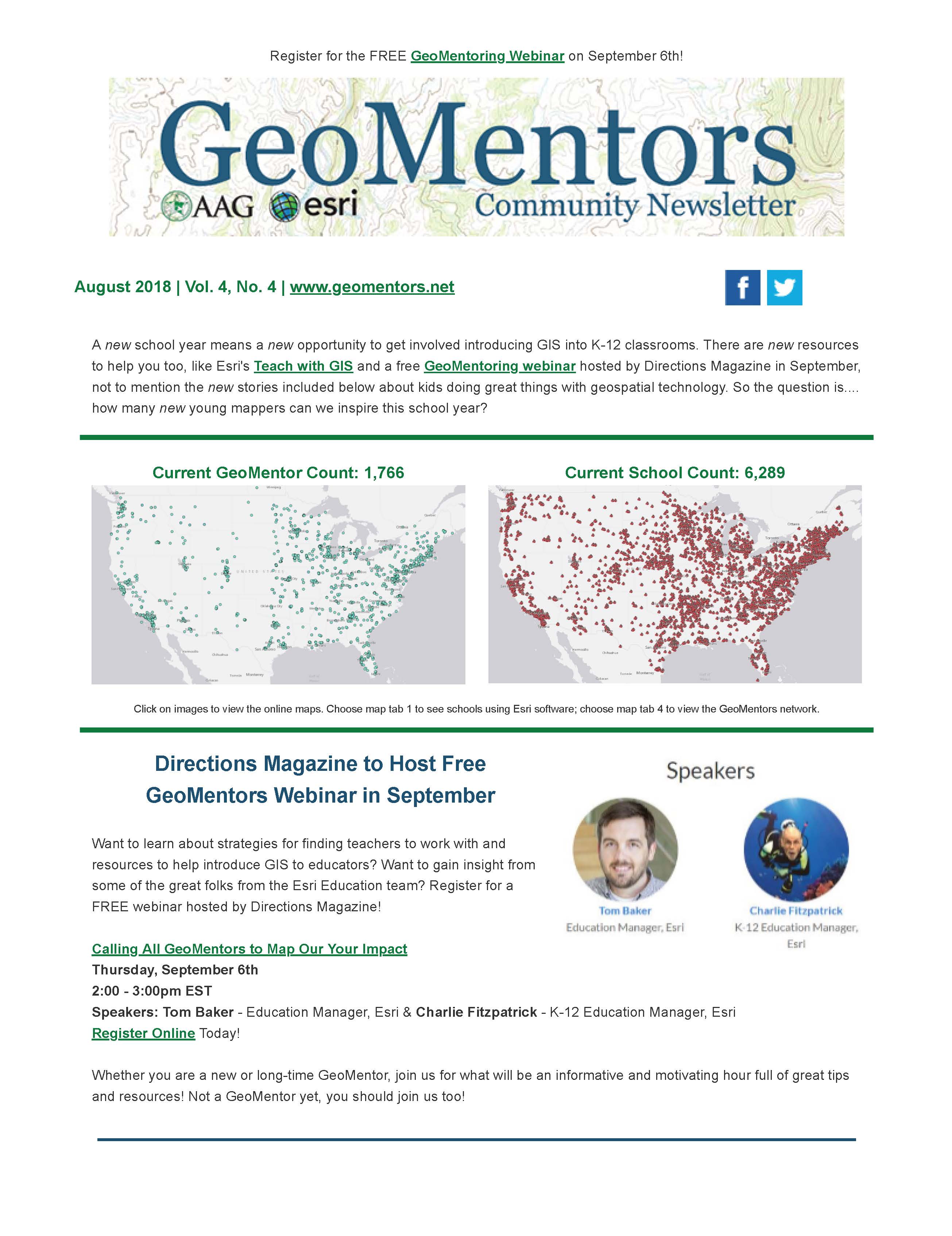
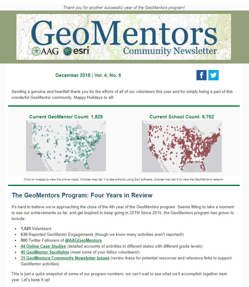
Approximately how many students were engaged in GIS activities through this collaboration: Approximately 25 students were engaged in GIS activities across 8 different schools located in 5 school districts were visited by NEPA GeoMentors as we introduced over 150 students to ArcGIS mapping technology.

How did you connect with your collaborator? This collaboration is an ongoing effort. We are in our second year of GeoMentoring with the SHINE Program. We met in the summer of 2016 through a PennDOT Transportation Improvement Program Public Outreach Meeting where a representative for Senator John Yudichak was present. When I explained that I was a GeoMentor and we were in search of schools, students and teachers to partner with. The representative asked that I contact to Carol Nicholas Executive Director of the SHINE Program and since 2016 our collaboration has been monumental.

Describe your collaboration process. Throughout the 2017-2018 we communicated with SHINE representatives primarily through email on a monthly basis setting up dates and schools to visit in the SHINE Program. Depending on the time of year, technology available to us, the age of students and the school we planned to visit were factors in deciding which story maps we would review.

This collaboration was ongoing throughout the 2017 - 2018 school year beginning in the fall and wrapping up in the spring.

In addition to reviewing story maps, as we visited each SHINE location we printed out an aerial wall map of the campus which was studied by the students in order for them to gain a spatial understanding of their surroundings. Student's also received an 8.x11 map of their campus or them to take home as a souvenir.

Describe the tasks you assisted your collaborator with. Our situation is a bit unique where we have the opportunity to visit schools in the SHINE After School Program as guest speakers. Our collaboration with the after school teachers happens on the set and we essentially freestyle our GeMentoring tasks depending on the age of the class, technology that is available to us and the time of year.

What available resources, if any, did you use or help your collaborator use to implement GIS in K-12 education? We printed out the GeoMentor flyers an handed them to the students and teachers at each SHINE location we visited. We refereed to the Amazon HQ2 US Finalists story map on a number of occasions for students to review http://mediamaps.esri.com/AmazonHQ2_USFinalists/index.html

Did you develop any new educational material or GIS activities through your collaboration? We developed a SHINE GIS Gallery that is home to some of the maps we demo in class. We review these maps with students to teach them basic mapping tools.

SHINE GIS Gallery: https://wbctcshine.maps.arcgis.com/home/index.html

SHINE Centers Locator: https://arcg.is/0fnGea
Find A Food Pantry: https://arcg.is/vXKbS
Adventures in GeoMentoring: https://arcg.is/0XKyrP
National Donut Day Dunkin Donuts in NEPA: https://arcg.is/0841Dz
Lights On After School: https://arcg.is/bW80u

Crowdsource map examples include:
NEPA Pizza Review https://arcg.is/1LD5OD
Doodle Dogs Around the World: https://arcg.is/1e1rKL

What did you gain from the experience? What do you think your educator collaborator and/or the students gained? NEPA GeoMentors gained a new understanding to the the challenges we face in the education industry when it comes to Geography as priority. In Northeastern Pennsylvania it seems the Geography curriculum is becoming extinct. We feel that as GeoMentors it is our mission to shed light on the GIS industry by introducing students and teachers with next gen mapping tools that will be prepare a workforce of the future.

There is always something to gain when instructing, teaching or coaching children. We have always taken tons of knowledge with us when engaged with any student. One thing we’ve taken away, as all teachers do, is how difficult teaching really is. We always mention and talk about how exhausted we are after instructing young students. The students and educators gained the knowledge and the many uses of the GIS tool. The ESRI GIS software has endless educational applications and all the students and faculty have gained that understanding.

We hope the teachers and students have found a new way to learn and a new way to teach by means of Esri story maps.

If your GeoMentoring engagement activities were documented through a classroom blog, school website, group’s social media post, newspaper or other media, please provide the websites of those posts.
2017-2018 NEPA SHINE Story Map https://arcg.is/iyPK8 that documents each school visit with a description and picture gallery link.
2017 - 2018 SHINE Photo Gallery www.nettiequette.com/folder/24714k

Any additional comments about your experience? We are thankful for the opportunity to be GeoMentors and pray that one day we will make a difference in the lives of these students giving them a career option they didn't know existed.


Check out more case studies here!

If you're interested in submitting your GeoMentor experience for a case study, we would appreciate you doing so through this survey. The collected information will only be accessible to and used by AAG and Esri program staff and will not be further distributed or posted  unless you indicate your permission to do so.

more
1 0 549
JoleneKeen1
Frequent Contributor

GeoMentor Case Study:

Lauren Sinclair

By Lauren Sinclair; GeoMentor/Educator in Portland, Oregon

How might your career or understanding of the world be different if you had learned GIS skills in middle school? Thanks to support from PSU professors David Banis and Dr. Hunter Shobe, an International Baccalaureate middle school in Portland’s west hills is being given the chance to find out.

The French American International School is nestled on the western edge of Forest Park, just below the crest of iconic Skyline Boulevard. Visit campus on a Wednesday and you’ll likely see 6th or 8th graders wandering around in small groups with smartphones in hand. They’re using ESRI’s Collector app to create novel maps of their school campus that contribute to their school’s community.

“I decided to make an accessibility map displaying the easy, medium, and hard routes getting from place to place when being on a wheelchair on campus,” says Sofia, an 8th grader in the school’s new GIS Design class. This map was inspired by analyzing several maps in Banis’ and Shobe’s book Portlandness. The students working on this map project will present their final interactive Web App (made using ArcGIS ) to the professors for analysis, as well as to the school’s administration as a bid for more accessible campus design in upcoming construction projects. "Let's say we add this map in every [student] planner in addition to the [existing] campus map,” says Coco, another 8th grader working on the project. “I think that could be really helpful for students to think from that point of view and learn about how difficult [traveling via wheelchair] is." This student-led initiative could change this school for the better.

Every semester, students in two GIS Design classes learn about how GIS works, how to make their own GIS maps of campus using a free AGO Enterprise account (thank you, ESRI!), how to analyze maps effectively, basic principles of map design, and how to lie with maps. As students at an international school, they’re able to apply their learning to geography-based inquiry in other classes as well. All 6th graders this year “discovered” the Ring of Fire through a GIS inquiry hosted in their Science classes, for example. More connections are being planned for the future, as GIS Design teacher Lauren Sinclair envisions “foundational GIS experience for every student” in coming years.

These new GIS connections were made possible because of Sinclair’s GIS training in PSU’s Geography Department. Sinclair was a public school teacher and environmental educator before coming to PSU to study glacial geomorphology, GIS, and geography in general. After taking Cartographic Applications of GIS with David Banis, Sinclair was inspired to pitch the idea of a middle school curriculum that would teach GIS basics to kids using free software like AGO. It took years of convincing to persuade school administrators to support the idea, but Sinclair was finally cleared to add two GIS classes to a list of electives for the 2017-2018 school year, and they’ve been a hit. GIS Design is now cemented into the school’s schedule.

“The success of these new classes is directly linked to our partnership with David and Hunter,” Sinclair reports. “I take exit surveys of my students, and they cite our GeoMentors as a huge motivating factor in their design process.” “I think it was useful because we were hearing from a professor that has been teaching about GIS and is very experienced with it,” said one 6th grader. “It also gave insight on how designers use the design process in real life.”

Would YOU consider acting as a GeoMentor for local middle school students? Professionals and students alike are needed in schools across the Portland area. Only a handful of middle schools in the country are teaching GIS, mostly because teachers aren’t familiar with it. YOU can help bridge that experience gap.

To learn more, email geomentors@aag.org or contact Lauren Sinclair at the French American International School to learn more about how GIS education is working in her classroom: lsinclair@faispdx.org

A work in progress: “Pokemon Go” from scratch by 8th grade enthusiasts


Check out more case studies here!

If you're interested in submitting your GeoMentor experience for a case study, we would appreciate you doing so through this survey. The collected information will only be accessible to and used by AAG and Esri program staff and will not be further distributed or posted  unless you indicate your permission to do so.

Questions? Email geomentors@aag.org.

more
0 0 1,078
JoleneKeen1
Frequent Contributor

GeoMentor Case Study:

Patrick J. Phillips, GISP

In conjunction with National Surveyors Week, Southeastern Surveying & Mapping Corp., Inc. (SSMC) participated in presenting Surveying & Mapping as a career to Lockhart Middle School on March 27th & Rock Lake Middle school on March 28th. James Mazurak and Patrick Phillips from the Orlando office of SSMC along with Lenora Spence, Outreach Coordinator from Florida Department of Agriculture visited the two schools.

At Lockhart Middle school the presentations were made to about 50 students (30 6th graders, and 20 7th graders). At Rock Lake Middle school, three or four classes of mixed grades and ages met in the schools media center as one big group of about 60 students. James explained about Surveying & Mapping using videos, slides and personal experiences, while Patrick physically demonstrated his drone skills in the school yards. This was part of the ongoing community involvement & education that SSMC is involved with throughout the year with students ranging from Elementary School to College.

Beyond the math, science and technology involved; James explained that what draws him to the surveying profession is the time spent in the field. Most geographers, regardless of specialty, are drawn to the outdoors and all that nature has to offer. Much of surveying & mapping is following in the footsteps of those who came before us. Consequently; many practitioners are also historians and conservationists.

I have to admit, though, the technology is pretty cool and that is what drew me to the profession. I studied computer science in college but like many mappers, followed my family into the profession. So I am now applying my computer skills to surveying and mapping. The UAS portion of SSMC’s presentation primarily explained the technology behind the aerodynamic capabilities of the UAS; GPS, IMUs, accelerometers and counter rotating propellers. The students asked questions like “how high can it go?” And “can you make it flip?” Far fewer students were interested in the photogrammetry and math required to process the data.

Check out more case studies here!

more
0 0 595
JoleneKeen1
Frequent Contributor

The August 2018 GeoMentors newsletter is out!  View the full issue here.

more
0 0 262
27 Subscribers