- Home
- :
- All Communities
- :
- Products
- :
- Data Management
- :
- Geodatabase Questions
- :
- Re: simple sde.st_buffer spatial view, ORA errors
- Subscribe to RSS Feed
- Mark Topic as New
- Mark Topic as Read
- Float this Topic for Current User
- Bookmark
- Subscribe
- Mute
- Printer Friendly Page
simple sde.st_buffer spatial view, ORA errors
- Mark as New
- Bookmark
- Subscribe
- Mute
- Subscribe to RSS Feed
- Permalink
I want to create a spatial view that draws a buffer around my input features, like this:
SELECT
a.OBJECTID,
sde.st_buffer (a.SHAPE, 33) as SHAPE
FROM schemaname.tablename a
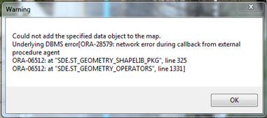
WHERE OBJECTID IS NOT NULLI get the following errors:


Any ideas what the problem could be?
Geodatabase version 10.3; Oracle version 12.1.0.2. Configured according to this doc.
- Mark as New
- Bookmark
- Subscribe
- Mute
- Subscribe to RSS Feed
- Permalink
Make sure the Extproc was configured correctly. I just ran a quick test and it is working fine.
Connect as SDE in SQLPlus and execute the below query. If it gives you an error instead of returning a result as below, the Extproc has not been configured correctly then:
SQL> select sde.ST_AsText(SDE.ST_Geometry('POINT (10 10)', 0)) from dual;
SDE.ST_ASTEXT(SDE.ST_GEOMETRY('POINT(1010)',0))
--------------------------------------------------------------------------------
POINT ( 10.00000000 10.00000000)- Mark as New
- Bookmark
- Subscribe
- Mute
- Subscribe to RSS Feed
- Permalink
Thank you for your reply Asrujit. I found this Esri doc. that describes a configuration consideration with Oracle 12: http://support.esri.com/en/technical-article/000012391
Your test query (...from dual) works now. My view still fails with the same error, but I'm actually not sure anymore that Esri can create new geometries (e.g. buffer) via spatial views that I can then consume in ArcMap/ArcGIS Server.
- Mark as New
- Bookmark
- Subscribe
- Mute
- Subscribe to RSS Feed
- Permalink
Error: ORA-06598: insufficient INHERIT PRIVILEGES privilege" during Oracle 12c Data Pump import this Article mentions about database Restore issues, so it should not be related to your problem.
As I mentioned in my first Post, I tried the same SQL that you are using and it works as expected and I can see the View in ArcMap. So using it in ArcGIS Server should work as well.
SELECT a.OBJECTID, sde.st_buffer (a.SHAPE, 65) as SHAPE
FROM sde.Testdata a
WHERE OBJECTID IS NOT NULLI used the above and it works perfectly.
I was using Oracle 11.2.0.4 and a 10.2.1 geodatabase for the quick test, which was readily available to me.
- Mark as New
- Bookmark
- Subscribe
- Mute
- Subscribe to RSS Feed
- Permalink
Ok, so it is possible. Thank you.
I had to 'GRANT INHERENT PRIVILEGES ON ...' to get even your simple test query to work. Now I guess I have to look further....
- Mark as New
- Bookmark
- Subscribe
- Mute
- Subscribe to RSS Feed
- Permalink
So this is how it looks in ArcMap and I believe this is what you wanted..
- Mark as New
- Bookmark
- Subscribe
- Mute
- Subscribe to RSS Feed
- Permalink
Just to close this thread: it turned out that our libst_shapelib file was quite old. After we replaced it with a more recent one the error does not appear.
- Mark as New
- Bookmark
- Subscribe
- Mute
- Subscribe to RSS Feed
- Permalink
Thanks for sharing the resolution.