- Home
- :
- All Communities
- :
- Products
- :
- Data Management
- :
- Geodatabase Questions
- :
- Accessing rasters within Postgres Database
- Subscribe to RSS Feed
- Mark Topic as New
- Mark Topic as Read
- Float this Topic for Current User
- Bookmark
- Subscribe
- Mute
- Printer Friendly Page
Accessing rasters within Postgres Database
- Mark as New
- Bookmark
- Subscribe
- Mute
- Subscribe to RSS Feed
- Permalink
We're working with a mix of different software to store and query our data on our PostgreSQL Server. We've found a way to deal with geometry data and convert the default st_geometry datatype into postGIS "geometry" and thus can query the data from inside R, for example, without external tools.
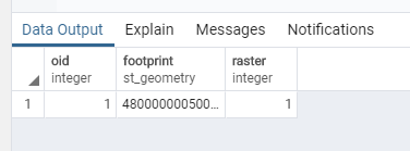
When storing our raster data on the server, this task becomes much more difficult. Viewed in pg admin, my raster dataset consists of a table with a single row of the following columns: oid (integer), footprint (st_geometry), raster (integer).
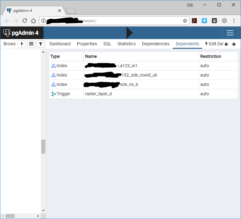
Where is the raster file (BLOB?) stored? We've searched through our database, but couldn't find anything relevant. Maybe these dependents give a hint?
- Mark as New
- Bookmark
- Subscribe
- Mute
- Subscribe to RSS Feed
- Permalink
Not sure which version of ArcGIS you are using, but the below details may help you:
Dataset system tables—Help | ArcGIS Desktop
Raster datasets and raster catalogs
Raster data is spatial data represented in an array of equally sized cells arranged in rows and columns. Raster data is composed of one or more raster bands. When you create or import a raster dataset, a raster column is added to the base table when it is created in the database. Each cell of the raster column contains a reference to a raster stored in a separate raster table.
Each raster dataset or raster catalog contains a base table that stores attributes, a raster column, and the footprint (the area) of the raster.
Raster images and properties are stored in the following tables:
- SDE_AUX_<raster_column_ID>
- SDE_BLK_<raster_column_ID>
- SDE_BND_<raster_column_ID>
- SDE_RAS_<raster_column_ID>
- SDE_VAT_<raster_column_ID>—Optional table to define attributes for raster cell values of a raster dataset.
- SDE_VAT_<raster_column_ID>_<Object_ID>—Optional tables to define attributes for raster cell values of a raster catalog. Each raster catalog can have several of these tables.