- Home
- :
- All Communities
- :
- Developers
- :
- File Geodatabase API
- :
- File Geodatabase API Questions
- :
- How to get Projection Details(GCS / PCS) using fil...
- Subscribe to RSS Feed
- Mark Topic as New
- Mark Topic as Read
- Float this Topic for Current User
- Bookmark
- Subscribe
- Mute
- Printer Friendly Page
How to get Projection Details(GCS / PCS) using file Geodtabase API.
- Mark as New
- Bookmark
- Subscribe
- Mute
- Subscribe to RSS Feed
- Permalink
Hi,
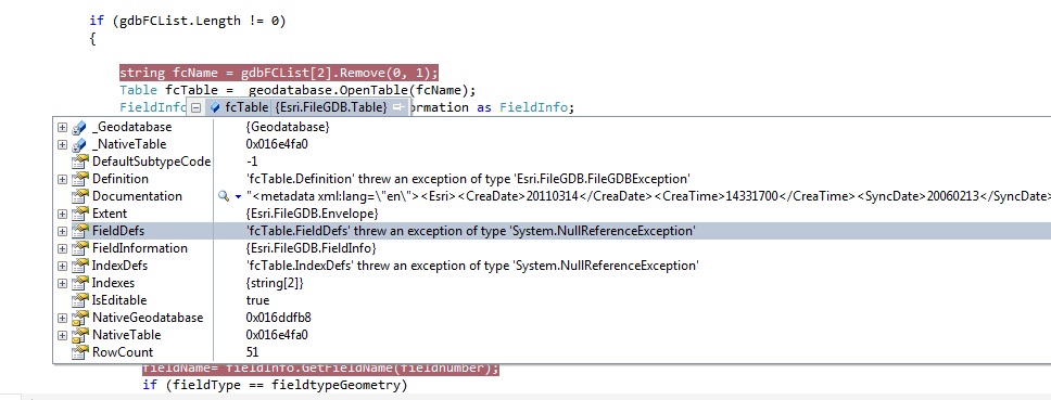
I would like to get the spatial reference of the feature class using file Geodtabase API.I am using FGDB API 1.4 and C# VS 2010. I have tried to use FieldDef to get Spatial Reference but receiving null error. Please guide me. Also attaching the error message.

string fcName = gdbFCList[2].Remove(0, 1);
Table fcTable = _geodatabase.OpenTable(fcName);
FieldInfo fieldInfo = fcTable.FieldInformation as FieldInfo;
FieldDef[] fieldDefs=fcTable.FieldDefs;
also tried following code
string spr = fcTable.FieldDefs[2].geometryDef.spatialReference.ToString();
- Mark as New
- Bookmark
- Subscribe
- Mute
- Subscribe to RSS Feed
- Permalink
It's difficult to tell from your question what error was generated from what code.
While a ToString exists on all objects, the documentation offers a SpatialReferenceText property to return "The Text Representation of the Spatial Reference System."
If you can post a more complete example, either using the sample data included with the API, or with your data included in the question, and for testing purposes, with each object in the retrieval process as it's own object, with error trapping at each stage, and with the complete output of the test, we'll probably be better able to help you.
- V
- Mark as New
- Bookmark
- Subscribe
- Mute
- Subscribe to RSS Feed
- Permalink
You didn't include your output, and your code still assumes that the geometry field will be in the third column (array radix 2). If you don't test the column type of the columns, and attempt to extract a coordinate reference from a string field, a null GeometryDef is the correct response.
- V
- Mark as New
- Bookmark
- Subscribe
- Mute
- Subscribe to RSS Feed
- Permalink
I am facing problem with FieldDef and it throw null while assigning to FieldDefs (FieldDef[] fieldDefs = fcTable.FieldDefs; ).
I have declared it after validating geometry. But still receiving the same null error in the FieldDef.
My out put is get the spatial reference/Projection Name of Feature class or Feature Dataset as a string.
Please find the attached updated code.
- Mark as New
- Bookmark
- Subscribe
- Mute
- Subscribe to RSS Feed
- Permalink
Best practice is to construct a simple test without extraneous function calls, so that the operation order is clearly evident. Adapting existing code is fine, if the file is renamed and the fat trimmed away.
As this question has morphed from proper method invocation to a casting issue, I'm going to have to leave it to someone who uses C# to review what may be wrong.
- V
- Mark as New
- Bookmark
- Subscribe
- Mute
- Subscribe to RSS Feed
- Permalink
The code throws null error when i try to cast FieldDef ( FieldDef[] fieldDefs =fcTable.FieldDefs;)
While debugging, the definition( FieldDefs, IndexDef)properties in the Esri:FileGDB:Table getting null values (Also tried with other C# samples provide with File Geodatabase API). Can any one tell me why it is throwing null value and can i get Spatial Reference Details using File GeoDatabase API without using FieldDefs.
- Mark as New
- Bookmark
- Subscribe
- Mute
- Subscribe to RSS Feed
- Permalink
And I'm having the same issue. Whenever I try to access FieldDefs, its null
- Mark as New
- Bookmark
- Subscribe
- Mute
- Subscribe to RSS Feed
- Permalink
I'm having the same issue. Whenever I try to access FieldDefs, its null.
Did you solve this?
- Mark as New
- Bookmark
- Subscribe
- Mute
- Subscribe to RSS Feed
- Permalink
.........
Table table = geodatabase.OpenTable(\\featuredatasetname);
// get table definition anp put in xml
var ds = table.Definition;
var xmlDocument = new XmlDocument();
xmlDocument.LoadXml(ds);
//parse xml nodes
/*
...
<WKT>GEOGCS["GCS_WGS_1984",DATUM["D_WGS_1984",.......
<WKID>4326</WKID>
</SpatialReference>
*/