- Home
- :
- All Communities
- :
- Products
- :
- Esri Software Security & Privacy
- :
- Esri Software Security & Privacy Questions
- :
- Re: Arcgis.com Cert Error in Tableau Server
- Subscribe to RSS Feed
- Mark Topic as New
- Mark Topic as Read
- Float this Topic for Current User
- Bookmark
- Subscribe
- Mute
- Printer Friendly Page
Arcgis.com Cert Error in Tableau Server
- Mark as New
- Bookmark
- Subscribe
- Mute
- Subscribe to RSS Feed
- Permalink
Having an issue connecting an AGOL service in Tableau Server. Receiving the error, "Internet communication error: SSL connect error (tiles.arcgis.com)."
Does anyone know how to get an SSL Cert from Esri for arcgis.com? Does this need to come from the administrator of the AGOL account, or from Esri?
I have found numerous resources on connecting Tableau to ArcGIS Enterprise and resolution for cert issues through administrator accounts, however none of them apply to this issue.
- Mark as New
- Bookmark
- Subscribe
- Mute
- Subscribe to RSS Feed
- Permalink
Hi John,
I'd be surprised if the certificate used on tiles.arcgis.com is untrusted by Tableau - the cert's from Digicert, which is a well known CA. Importing a cert into Tableau's keystore may be a requirement for lesser known Certificate Authorities, domain certs not provided by a commercial CA or self signed certs, but in general certs from well known CAs are already in various keystores. Which version of Tableau are you using - and as a CLIENT, does the version of Tableau you're working with support TLS 1.2? Resources on ArcGIS.com require clients to support TLS 1.2. Another question: when did this start happening? Did it work before? ArcGIS Online made the switch to require TLS 1.2 in April 2019.
- Mark as New
- Bookmark
- Subscribe
- Mute
- Subscribe to RSS Feed
- Permalink
Hello Randal-
Thank you for your reply. It was very helpful. We are using version 2019.3 (Server) and 2019.4 (Desktop) of Tableau.
We figured out what caused this problem with the SSL error. It was an issue with port “80” being set in the file format vs. port “443" which is needed for secure transfer. ESRI’s documentation does not inform a person not familiar with SSL protocols why it is important to make sure the correct port number is used.
We are currently trying to figure out a url that is in the TMS format. We haven't been able to find anything online about this.
Do you know what the entry in the TMS format should look like in order to consume Esri's services?
- Mark as New
- Bookmark
- Subscribe
- Mute
- Subscribe to RSS Feed
- Permalink
Interesting. I've personally never used Tableau, but I can state:
a. Ports 80 and 443 are the "standard" ports for http and https. That's why you don't need to qualify a port number in most web requests - like, a browser will know that a request to https://google.com will go to 443 on the remote server.
b. However, in some cases the client must specify the port number - for instance, you may have a non-default site where a user must make a request to https://randall.com:8443/index.html - becuase :8443 isn't a standard https port.
These resources might help:
How to Use ArcGIS Data, Features and Basemaps in Tableau
https://community.tableau.com/ideas/6756#comment-24519
I took a look at some example TMS files.
Assuming this example is up-to-date, then the syntax "should" look like this:
<?xml version="1.0" encoding="utf-8"?>
<mapsource inline="<boolean>" version="8.1">
<connection class="OpenStreetMap" indicator-server="services.arcgisonline.com" intermediate-levels="0" layer separator="/" max-scale-level="16.0" max-stretch="1.0" min-shrink="1.0" offline="" port="443" server="services.arcgisonline.com" url-format="arcgis/rest/services/USA_Topo_Maps/MapServer/WMTS/tile/1.0.0/USA_Topo_Maps/default/default028mm/{Z}/{Y}/{X}.png"/>
<layers>
<layer display-name='Base' name='base' show-ui='false' type='features' request-string='/' />
</layers>
</mapsource>
You'd want to update the bold section with the name of the basemap you're consuming. The example above was pulled from the WMTS capabilities file for the USA_TOPO map here http://services.arcgisonline.com/arcgis/rest/services/USA_Topo_Maps/MapServer/WMTS/1.0.0/WMTSCapabil...
- Mark as New
- Bookmark
- Subscribe
- Mute
- Subscribe to RSS Feed
- Permalink
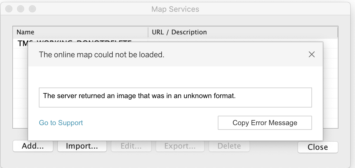
Hi Randall-
Thanks for the quick response! I think we are getting closer.
We tried the following and got the attached error. Any ideas from this?
- Mark as New
- Bookmark
- Subscribe
- Mute
- Subscribe to RSS Feed
- Permalink
hmmm 2 things:
a. I think it should be /tiles/j75S08un0OPoEcHD/arcgis/rest/services/LSIB9_polygons/MapServer/WMTS/tile/1.0.0/LSIB9_polygons/{Style}/{TileMatrixSet}/{TileMatrix}/{TileRow}/{TileCol}.png
Check out this link, there are good suggestions there:
Documentation of Tableau Map Service Connections |Tableau Community Forums
- Mark as New
- Bookmark
- Subscribe
- Mute
- Subscribe to RSS Feed
- Permalink
Hi Randall, this is the latest connection tag we've tried:
<connection class="OpenStreetMap" intermediate-levels="0" layer-separator="/" max-scale-level="16.0" max-stretch="1.0" min-shrink="1.0" offline="" port="443" server="tiles.arcgis.com" url-format="tiles/j75S08un0OPoEcHD/arcgis/rest/services/LSIB9a/MapServer/WMTS/tile/1.0.0/LSIB9a/{Style}/{TileMatrixSet}/{TileMatrix}/{TileRow}/{TileCol}.png" />
We've tried switching-up the LSIB9 vs.LSIB9_polygons but no avail. Any other suggestions?
- Mark as New
- Bookmark
- Subscribe
- Mute
- Subscribe to RSS Feed
- Permalink
At this point, I'd have to defer to Tableau support. I've never worked with their product so I'm unsure what it's expecting here.
- Mark as New
- Bookmark
- Subscribe
- Mute
- Subscribe to RSS Feed
- Permalink
Hi Randall-
Thanks for all the help so far!
We'll post what we figure out when we resolve the issue so that other people can benefit.
- Mark as New
- Bookmark
- Subscribe
- Mute
- Subscribe to RSS Feed
- Permalink
Hi Randall-
Just wanted to close this out in case it helps anyone else.
The final TMS File that worked looked like this:
<?xml version="1.0" encoding="utf-8"?>
<mapsource inline="true" version="2019.4">
<connection class="OpenStreetMap" port="443" server="https://tiles.arcgis.com" url-format="/tiles/j75S08un0OPoEcHD/arcgis/rest/services/LSIB9_polygons/MapServer/WMTS/tile/1.0.0/LSIB9_polygons/default/default028mm/{Z}/{Y}/{X}.png" />
<layers>
<layer display-name='Base' name='base' show-ui='false' type='features' request-string='/' />
</layers>
</mapsource>
Took a while to get to. There are not a lot of resources out there for support, so it was a lot of trial and error.
Thanks again for all of your help!