- Home
- :
- All Communities
- :
- User Groups
- :
- Elevation Data
- :
- Questions
- :
- How to Simplify Raster Category Boundary Inwardly ...
- Subscribe to RSS Feed
- Mark Topic as New
- Mark Topic as Read
- Float this Topic for Current User
- Bookmark
- Subscribe
- Mute
- Printer Friendly Page
How to Simplify Raster Category Boundary Inwardly Only
- Mark as New
- Bookmark
- Subscribe
- Mute
- Subscribe to RSS Feed
- Permalink
Hi All,
Is there a way to simplify a raster category boundary in the inwards direction only without closing off large chucks of the zone due to the narrowness of raster sections?
Below is an example... it is an accessibility raster, defining all connected section of land that can be driven on in blue.
What I want to do is create the yellow line as a polygon, which is a simplification of the blue edge. The conditions of the simplification is:
1) Simplification has to be inwards only. (Yellow line need to be completely within blue area)
2) Large accessible areas can be joined by very thin "Bridges", the connectivity between the large areas need to be maintained
3) the black island in the top right are also important (they are like traffic islands) and would be a doughnut cut out of the output polygon.
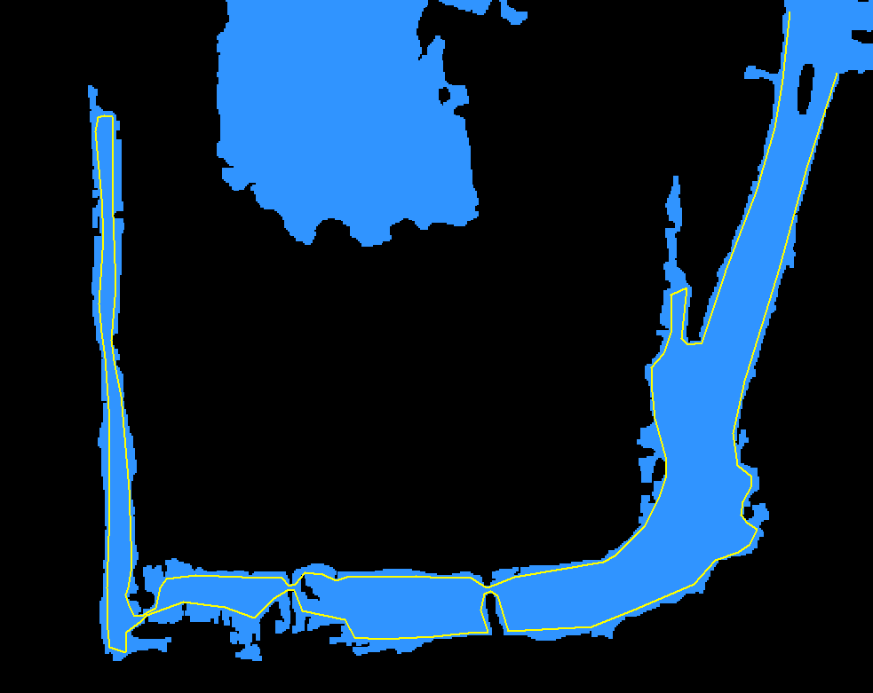
I wanted to use "Shrink/Swell to simplify the boundaries, however I found that is closes of fthe narrow bridges that join large areas, and removed the traffic islands I wanted to keep.
The logic I have thought of is: Simplify edge section as long as perimeter for that section is not greater than Xm OR area loss is not greater than Xsq meters.
But I don't know how to put this into some sort of raster calculation.
Thanks in advance 
- Mark as New
- Bookmark
- Subscribe
- Mute
- Subscribe to RSS Feed
- Permalink
You have gone through the majority of the raster filters,
maybe boundary clean is all that is left to try