Developers Blog - Page 3

cancel
Showing results for 
Show  only  | Search instead for 
Did you mean: 

Latest Activity

(103 Posts)
MarkCederholm
Frequent Contributor

As of 100.6, ArcGIS Runtime for .NET does not include overlay items when exporting a MapView using ExportImageAsync.  Here's a workaround for that.

Read more...

more
0 0 1,209
BlakeBilbo
Regular Contributor

Originally posted by Courtney Kirkham, September 18, 2019 from the MapThis! Blog

While OAuth 2.0 is Esri’s recommended methodology for handling security and authentication for their ArcGIS platform, not everyone using it understands what it does or how to implement it. Here at GEO Jobe, we’ve had to explain it to more than a few of the people we’ve worked with. As such, we thought we’d lay out a quick guide to what OAuth is and how it works.

OAuth 2.0 handles security and authentication for the ArcGIS platform. Image Source

What is OAuth 2.0?

OAuth 2.0 is the protocol that ensures only users you give permission to can access your ArcGIS content. Esri chooses to use OAuth 2.0 for a number of reasons, including this list they’ve provided:

  • OAuth 2.0 meets the needs of both users and applications.
  • There are strong security practices around OAuth 2.0.
  • OAuth 2.0 is designed to function at Internet-scale across domains, networks, cloud services, and applications.
  • As a widely accepted standard OAuth 2.0 has many libraries and helpers for a variety of languages and platforms.

This is an important part of security for controlling who can access or edit content, as well as managing credit usage. By using OAuth 2.0 in your applications, you can make a map of company assets available to anyone in your company while still keeping it hidden from the public. A company working on building a new neighborhood could create a map to track the progress of the homes being built, while ensuring only supervisors can edit the status of the houses.

Perhaps the most important way OAuth 2.0 manages security is controlling access to premium content and services. Since interacting with these resources consumes credits, and credits cost real money, OAuth 2.0 is an important part of making sure that only the people you want accessing those resources are able to do so.
(Bonus: For additional control over security while reducing the overhead in your in your org, check out security.manager)

You’re not getting that data without valid credentials. Image Source

How does OAuth 2.0 work?

Here at GEO Jobe, we’ve found the best way to explain how OAuth 2.0 is with an analogy. Say your friend, Chris, got access to some exclusive event – a networking opportunity, a party, or something like that. There is a private guest list for the event, and the doormen are checking everyone. Your friend tells you all you need to do is tell the doorman you’re there with Chris, and the doorman will let you in.

When you get to the event and check in with the doorman, one of three things can happen. We’ve outlined them each below, and explained what they mean in the context of OAuth 2.0.

The Doorman Finds Your Friend; You Get a Wristband and Go In

This is what happens when OAuth 2.0 works. You’re able to get in and see your friend. In the case of ArcGIS, this means you requested access to content that you have permission to see. After OAuth checks your credentials, they give you a token (the wristband) that’s added to all your requests for content after that. Then, you get whatever you need (that you have permission to view), and everything is good.

The Doorman Finds Your Friend and You Don’t Get In

This is when the doorman comes back and tells you they found Chris, but Chris says they don’t know you. While this may be an awkward social situation, in OAuth 2.0, it’s pretty simple. It means you tried to access content, and OAuth 2.0 doesn’t think you are supposed to be able to see it. This will often result in an “Invalid Redirect URI” error.

In terms of development, this happens because the request is coming from a URL the app doesn’t recognize. To fix it, go to the app in your ArcGIS used to register for OAuth 2.0. Then, in the Settings menu, view the “Registered Info”. The domain sending the request will need to be included in the Redirect URIs.

The Doorman Can’t Find Your Friend

Maybe your friend left the party. Maybe the doorman thought the “Chris” they were looking for was a “Christopher” instead of a “Christine”. Regardless of the reason, the doorman can’t find your friend, and they’re not letting you into the party. When this happens, OAuth 2.0 will return an error stating that there is an “Invalid Client ID”. This is also easy for a developer to fix.

This situation occurs because there isn’t an app in the ArcGIS Organization in question with an App ID that matches what OAuth 2.0 was told to look for. This can happen if the app was deleted from your ArcGIS Org, or if the code where the App ID was specified was altered. In order to fix it, check where the App ID is specified in the code for the OAuth 2.0 call. Also, check the application in ArcGIS Org used to register for OAuth 2.0. If the application was deleted, you will need to create and register a new application, then use that App ID. If the application exists, check under the “Settings” menu and the “Registered Info” to find the App ID. This should match the value for the App ID in the code. If it doesn’t, recopy the App ID from the application in the ArcGIS, then paste the value into the code where the OAuth 2.0 information is initialized.

How to Implement an OAuth 2.0 Application

Setting up an OAuth 2.0 application in your ArcGIS Organization is fairly simple. In fact, it only takes five steps! It’s so easy, we’ve outlined the process below.

1. To start, sign into your ArcGIS Org and go to the Content menu. From there, click on “Add Item” and choose the option for “An Application”.

2. Next, you’ll select the type “Application” and fill out some basic information.

3. After you add the item, go to the Settings page and click the “Registered Info” button. Note: While on the settings page, you may want to select the option for “Prevent this item from being accidentally deleted.

4. After clicking the “Registered Info” button, the App ID you will need should be visible on the left. The final step will be to update the Rediret URIs for the application. Click the “Update” button on the right side of the screen.

5. A popup with the Registered Info should appear. Any applications a developer builds that will need to OAuth into your ArcGIS organization will need to have their domains added to the approved Redirect URIs of an OAuth application. Add the appropriate domains in the textbox, then click “Add”. After your domains are all added, click the “Update” button at the bottom of the popup.

And there you have it! Five easy steps and you’re ready to use OAuth 2.0 in your ArcGIS Organization.

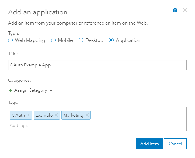
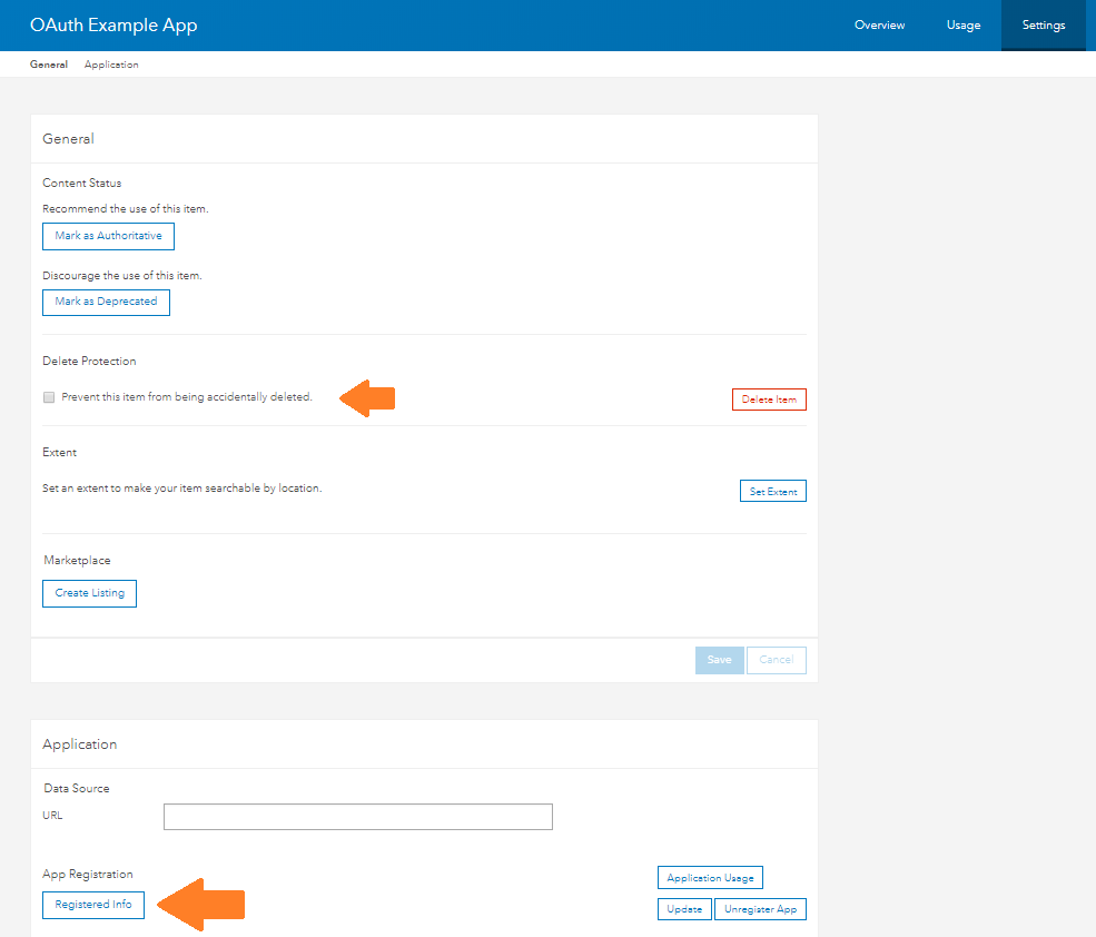
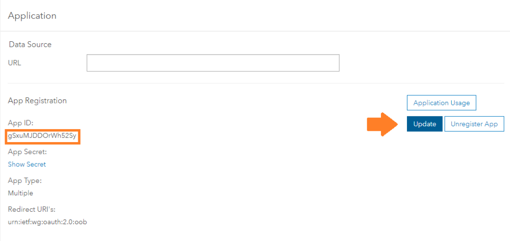
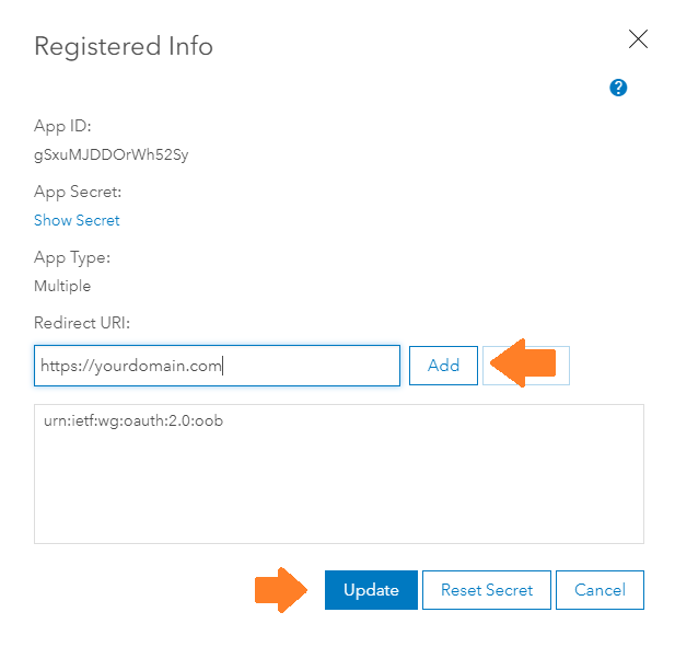
You can relax, knowing your ArcGIS content is safe and only accessible by who you choose. Image Source

Conclusion

Securing your ArcGIS data is important. OAuth 2.0 can make it simple. If you need any assistance setting up OAuth for your ArcGIS Organization, or need some custom applications built while keeping your data secure, reach out to us at connect@geo-jobe.com. We’ll be glad to help!

Liked this article? Here’s more cool stuff

more
2 4 12.8K
MattZand
Emerging Contributor

Bootstrap 4 is the latest version of Bootstrap at the time of writing. This version makes Bootstrap more powerful and easy to customize and use. One of amazing feature of Bootstrap 4 is Cards

Cards are a new component in Bootstrap 4 that replaces wells, panels, and thumbnails. A card is a flexible and extensible content container. It includes options for headers and footers, a wide variety of content, contextual background colors, and powerful display options.

To create a card, we need to use the .card class. By default, card width is 100% of its parent container. Therefore, here we are using a grid system to control width. Also, by default, cards use dark text and assume a light background. Add .card- inverse for white text and specify the background-color and border- color values to go with it. Bootstrap 4 also provides a few classes that add a background color and border color to cards.

Here are 3 examples where cards are used:

Ex1:

<div class="card-block">
<h4 class="card-title">Card title</h4>
<h6 class="card-subtitle">Support card subtitle</h6>
</div>

Ex2:

<div class="card-block">
<p class="card-text">
Lorem ipsum dolor sit amet, at suscipit sodales eget ante ultricies mauris. Etiam dolor felis morbi nibh, mollit porttitor tempor, dignissim magna pellentesque dictumst bibendum dictum integer.
</p>
</div>

Ex 3:

<div class="card-block">
<a href="#" class="card-link">Card link</a>
<a href="#" class="card-link">Another link</a>
</div>

Here is a link for more examples of Bootstrap 4 Cards

more
0 0 1,500
MarkCederholm
Frequent Contributor

Does the ArcGIS API for JavaScript work with Content Security Policy ?  The short answer is yes, but which version you're using (4.x vs. 3.x) determines the approach to take.  Let's take a look.

Read more...

more
1 5 6,782
AndresCastillo
MVP Alum

I received a request to provide all videos and other files available for an area of interest on the map.

Using ArcGIS Pro, I digitized a polygon to enclose the desired area.

Used this polygon to select all pipe line features that intersect this area.
Export the selected pipes to an excel.
Copy only the user-defined unique id field onto a local text file, as list1.txt
Ensure no extra newlines/whitespace at the beginning nor end of the file.

move list1.txt to a new directory labeled 'stagingFiles'.

Using the command line, write the  contents of the directory that contains the desired files to a local text file, as list2.txt:
dir /b > list2.txt
remove the value of 'list2.txt' from the text file, as well as the names of any subdirectories.
If subdirectories exist, create another text file within the subdirectory, as list2_1.txt, then move it to 'stagingFiles' directory, and repeat for other subdirectories.
remove the value of 'list2_1.txt' from the text file, as well as the names of any subdirectories, and repeat for other subdirectories.

Use this python script, and follow the remainder instructions within it:

import re


with open(r'\\cityhall\data\GIS_MAPS\AndresCastillo\toDo\stormCCTVReportsVideos3336NFlaglerOutfallImprovementsTicket40365\stagingFiles\list1.txt', 'r') as f:
    generatorOfFileLines = [line.strip()for line in f]
    a = generatorOfFileLines
    for i in range(len(a)):
        pattern = re.compile(r'(.*)' + str(re.escape(a[i])) + r'(.*)')
        with open(r'\\cityhall\data\GIS_MAPS\AndresCastillo\toDo\stormCCTVReportsVideos3336NFlaglerOutfallImprovementsTicket40365\stagingFiles\list2.txt', 'r') as g:
            contents = g.read()
            matches = pattern.finditer(contents)
            for match in matches:
                results = match.group(0)
                print results
        i +=1


print "Copy and paste the results of the Regular Expression (above this printed statement) to a text file, as list3.txt, save it, and close it."
resultsFile = raw_input("paste path to text file here: ")
# \\cityhall\data\GIS_MAPS\AndresCastillo\toDo\stormCCTVReportsVideos3336NFlaglerOutfallImprovementsTicket40365\stagingFiles\list3.txt

with open(r'{}'.format(resultsFile), 'r') as h:
    b = [line.strip()for line in h]
    c = list(set(b))
    for i in range(len(c)):
            print c[i]
   
print 'Now take the results above, and paste to the list4.txt file (move the text file to the intended directory to search for files)' 
print 'This file is used in conjuction with the command line argument FOR /F "delims=" %N in (list4.txt) do COPY "%N" "C:\\targetFolder" to copy and paste files to an intended directory'
print 'If subdirectories exist, make a new list3.txt from the list2_# (by changing the file name in the path above), and perform the instructions in this script again.'
print 'find out what to do when a filename collides with another, like.........command overwrite yes no all.....'
print 'Separate the cmd line results to single out the files that did not copy successfully'
print 'If feasible, change the filename to its current name, and append "_1" to it.'
print 'once done, remove the list4.txt, and target folder (if applicable) from the intended directory.'
print "______________________________________________Operation is Complete"     


# Try the findall() method without groups, and it should work.
# Another use case for regex would be for validating user input in client apps to ensure what they input meets a criteria.


    # Didn't work

        #     subbedContents = pattern.sub(r'\0', contents)
        #     print subbedContents
        # i +=1


    # for dirpath, dirnames, filenames in os.walk(r'\\cityhall\data\GIS_MAPS\AndresCastillo\toDo\stormCCTVReportsVideos3336NFlaglerOutfallImprovementsTicket40365\test'):
    # \\GIS-WEBAPP\Hyperlinks\StormCCTV 
        # for file in filenames:
        #     matches = pattern.finditer(re.escape(file))
        #     print matches
        #     for match in matches:
        #         print match


        # Didn't work for list4.txt:
        # trimmedResultsFile = r'\\cityhall\data\GIS_MAPS\AndresCastillo\toDo\stormCCTVReportsVideos3336NFlaglerOutfallImprovementsTicket40365\stagingFiles\list4.txt'
        # with open('{}.format(trimmedResultsFile)', 'w') as j:
        #     j.write(str(c))


# fnmatch and os modules did not work


# To get the filenames of the resources in a directory:

# Hold the "Shift" key, right-click the folder and select "Open Command Window Here." 
# This only works with folders, not libraries.

# Type "dir /b > dirlist.txt" without quotes and press "Enter." 
# This creates a list containing file names only. 

# Open Microsoft Excel and press "Ctrl-O" to bring up the Open dialog window.

# Open Txt file in Excel‍‍‍‍‍‍‍‍‍‍‍‍‍‍‍‍‍‍‍‍‍‍‍‍‍‍‍‍‍‍‍‍‍‍‍‍‍‍‍‍‍‍‍‍‍‍‍‍‍‍‍‍‍‍‍‍‍‍‍‍‍‍‍‍‍‍‍‍‍‍‍‍‍‍‍‍‍‍‍‍‍‍‍‍‍‍‍‍‍‍‍‍‍‍‍‍‍‍‍‍‍‍‍‍‍‍‍‍‍‍‍‍‍‍‍‍‍‍‍‍‍‍‍‍‍‍‍‍‍‍‍‍‍‍‍‍‍‍‍‍‍‍‍‍‍‍‍‍‍‍‍‍‍‍‍‍‍‍‍‍‍‍‍‍‍‍‍‍‍‍‍‍‍‍

Sent the client the requested files.

Resources:

Google:
How Do I select multiple files in a folder from a list of file names
Select multiple files in same folder with variations of filenames python
Select multiple files in same folder with variations of filenames python regular expression
write contents of directory to text file.
Select variations of many file names at once python regex
regular expression tester

https://pymotw.com/2/glob/
https://docs.python.org/2/library/fnmatch.html

https://www.tenforums.com/general-support/110415-how-do-i-select-multiple-files-folder-list-file-nam...
How Do I select multiple files in a folder from a list of file names

16 May 2018 #4

Welcome to TenForums @SGTOOL

The simplest way to use a text file with a filename on each line (such as list.txt) to copy the files to a folder such as C:\Destination is by using this single command in a command prompt:

FOR /F "delims=" %N in (list.txt) do COPY "%N" "C:\targetFolder"

'for' loops through all the filenames in list.txt
"delims=" says use the whole of each line as the parameter %N
the quotes around %N in 'copy "%N"' allows for any filenames that contain spaces
C:\Destination specifies the folder you want to copy to (it must already exist, create it first if necessary)

If the text file contains just the file names, then the command has to be run in the folder that contains the files to be copied. To go to that folder, first use the 'change directory' command: CD <full path to the folder>
eg: CD C:\Source_folder

If the text file contains the full path and filename on each line, eg:
C:\Users\Me\Pictures\SourceFiles\Filename.jpg
...then the CD step is not needed.

If the text file is in a different folder, give the full path to it in the FOR command, eg: (C:\Temp\list.txt)

https://answers.microsoft.com/en-us/windows/forum/windows_vista-files/select-multiple-files-in-same-...
Select multiple files in same folder from a list of file names
Tiffany McLeod Replied on April 25, 2009

You can use a Excel Spreadsheet to automatically format the code and then copy and paste it into a text document which you would save as a *.bat file. I have a Spreadsheet I've created for this, and I'll share with you, you can download it by clicking on the following link (hopefully).

Download Excel Spreadsheet

How to Use:

Open the Spreadsheet.

At the bottom of the screen, you will see that there are two worksheets in this file.
If your list of names includes the the full file path (example: c:\weddings\sally\img1.jpg), choose the worksheet labeled "Full Path".
If your list only has the filenames (example: myimage.jpg), choose the worksheet labeled "Filename Only".

I'll explain the Filename Only worksheet:

Image

You will NOT enter any Data into the first three columns: that's the output.
In column E (Current Folder Path) Type the full folder path where the pictures are currently located. Make sure that you include the final "\", as shown above. You will only need to type this once.

The next Column (F) is the File Name Column. Paste your list of file names here, one name per cell (the list you paste from should have only one name per line). My spreadsheet allows for well over 200 filenames before the formulas stop working (for more files, simply extend the formulas).

Type the full path of the folder you want to move the pictures to into column G, as shown.

Now, we'll look back to the First three columns, A,B, and C. Find the spot where the output in column B no longer has a filename after the folder path. Select all the output in the three columns, above the ending line. For example, in the sheet above, the ending line is Line 7 (we don't want to include that line), so the selected range would be A2:C6. For two hundred files, the range would be A2:C202.

Copy.

Open notepad. Paste.

Save as a .bat file. (Choose save. Slect the folder you wish to save it in. Type move.bat into the name line. Make sure that "All files" is selected from the file type drop down list.) This .bat file is reusable. Simply right-click and choose edit to reuse instead of making a new one each time.

Once the .bat file is saved, double-click on it to run it.

Check your destination folder, and make sure the files moved as desired.

If you want to copy the files instead of move them, simply type COPY into cell A2.

Use the Full Path worksheet in the same manner, except you don't need to enter the current folder path into cell E2.

Now for the Disclaimer: Follow these instructions at your own risk. I take no responsibility for any damage caused to your data or system as a consquence of using my spreadsheet or following these instructions. Back up your data before using the .bat file.
You should test this process to make sure that you understand it, before using it for important files.

I freely admit that this is probably a bit clunky and inelegant, but it works and it is very versatile for generating large batches of DOS commands.

Best Wishes,
Tiffany McLeod aka BookwormDragon


https://realpython.com/working-with-files-in-python/#simple-filename-pattern-matching-using-fnmatch
Working With Files in Python
by Vuyisile Ndlovu Jan 21, 2019

https://thispointer.com/5-different-ways-to-read-a-file-line-by-line-in-python/
5 Different ways to read a file line by line in Python


https://www.sevenforums.com/general-discussion/201734-select-search-multiple-files-copy-paste-new-fo...
select/search multiple files, copy and paste to a new folder

Python

python snippets

Developer Communities

GP dev group

GIS Developers

Geo Developers

Developer Communities

GIS Developers

more
1 0 8,561
AmyNiessen
Esri Regular Contributor

Article written by Amy Niessen with contributions from Ciara Rowland-Simms

On Wednesday, May 15th the Cardiff R&D Center co-hosted a Rust and C++ birthday party at Yolk Recruitment to celebrate Rust's 4th Birthday! Despite short notice, we were able to get the word out in time for a nice mixture of full-time freelance and hobbyist programmers as well as a few students to join us. Quite a few people expressed interest in helping out with future events while demonstrating a lot of enthusiasm for a Rust/C++ community in Cardiff! 

To begin, you can't have a party without cake, and to celebrate the birthday properly, you can see the cake and Ferris the crab, which was made from icing by Jack Kelly's partner, Sofia.

cake and Ferris the crab


We then began to introduce our speakers. We had Dan Morgan from DevOpsGroup, Ciara Rowland-Simms from Esri, Chris Light from Esri, and Jack Kelly from DevOpsGroup, with Chris doubling as MC for the event.


The first two talks were about learning new languages, specifically Rust and C++.

Dan had never done C++ before until that week and spoke on the confusion you face when trying to find best practices and up to date learning materials online. His talk will be part of series documenting his journey into C++, driven by advice from the audience about what resources to use next!


Dan and Rust

Ciara did a talk on learning Rust, having also never used the language. By contrast, there is very coherent documentation story for Rust as it is a very modern language. The learning experience was therefore comparatively painless and she was able to cover install and setup, including debugging, along with discussing some cool and some controversial Rust language features (such as the heavy use of macros, the ability to do shadowing of variables, and implicit returns).

Ciara and Rust


Chris’s talk was Modern C++: ACCU 2019 revelations and covered some of the cool new features of C++ 20. He also discussed C++ 17 and more broadly the modernization of the language. The talk provoked some really good discussion on some of the network capabilities that are lacking in the standard library and provided a great space for talking about where the language is moving.

Chris and C++


The final talk was a dive in Rust best practices, helpful tips, formatting and linting tools, and how easy CI/CD can be with Rust. He really highlighted why people are so excited about Rust and how easily it can leveraged to hit the ground running even with only limited experience in the language.


In the end, we had some specific language questions, which is always good. It seemed there were a lot of really good discussions taking place during the event and, of course, people already sharing excitement in the anticipation of future meetups.


Going forward, we also hope to bring in more speakers – which hopefully won’t be difficult given the enthusiasm from audience members at our first event! We really liked having talks which were a mixture of beginner accessible and provoking good discussion for more experienced developers. We struck that balance pretty well this time and hope to do so again in future meetups.

Overall, we were really pleased with how the event went and are really excited to see the beginning of a Cardiff C++/Rust community where we can all learn from each other and grow! We look forward to the next meetup and will be sure to announce it on the Meetup.com page. Be sure to follow it to stay in the loop on our next adventure!

more
1 1 1,500
AmyNiessen
Esri Regular Contributor

Last month we hosted a unique GeoDev Webinar when we had Manushi Majumdar share her presentation on "Thinking Spatially and Statistically". Manushi introduced types and characteristics of spatial data and advanced GIS analysis techniques. She was able to cover a few basic concepts of statistics and show how they differ in a spatial context, advancing towards Spatial Machine Learning with ArcGIS. 

Here are the questions that were received during the webinar along with their respective answers:


Q: What is the difference between machine learning and statistics? For example, with regression, is there a difference? This always puzzles me!

A: Here is a resource to understand the difference: https://www.kdnuggets.com/2016/11/machine-learning-vs-statistics.html

Q: Is there any geo-processing tools in built in ArcGIS for running machine learning algorithms?

A: Yes, ArcGIS has support for several Machine Learning techniques. We would suggest looking this blog post to learn more about ML support within ArcGIS Desktop. https://www.esri.com/arcgis-blog/products/arcgis-pro/analytics/machine-learning-in-arcgis/

Q: Can you provide the link to the notebook again?

AHub-Tutorials/GeoDev_ServiceRequests.ipynb at master · esridc/Hub-Tutorials · GitHub 

Q: Are there any other good resources for finding examples of utilizing Machine Learning with GIS?

A: Here are just a few ArcGIS blogs demonstrating examples:
https://www.esri.com/arcgis-blog/products/product/analytics/density-based-clustering-exploring-fatal...


https://www.esri.com/arcgis-blog/products/arcgis-pro/analytics/using-forest-based-classification-and...


https://www.esri.com/arcgis-blog/products/arcgis-enterprise/analytics/the-science-of-where-seagrasse...


Q: Spatial Join: I see the tool has capability to join two layers with out common attributes . But can this be done on multiple layers in a single shot? The built-in tool has only option to select two layers. What are the options?

A: Join works on a 1:1 principle, you can only join one layer to another. That said you can use the concept of table 'Relate' to join one table to many using a common attribute in those tables (does not work spatially).

Q: Is it possible to integrate ArcGIS with machine learning software like Jupiter notebook?

A: You can use ArcPy as well as the ArcGIS API for Python in Jupyter notebooks. 

Q: Is there a way to use machine learning to predict or project possible future incident locations without assigning a z-value?

A: Z-score (standard score) denotes the number of standard deviations from the mean a data point is. Simply put, it conveys the distribution of a point around the mean. Prediction or Classification does not need z-scores for input variables.

Q: Could you walk us through the hotspot analysis? How do you access these tools?

A: Read through this https://pro.arcgis.com/en/pro-app/tool-reference/spatial-statistics/h-how-hot-spot-analysis-getis-or... to learn more about HotSpot Analysis. It can be accessed within the Spatial Statistics (Mapping Clusters) toolbox in ArcGIS Desktop and under the Analyze Patterns category in ArcGIS Online.

Q: Can we do the machine learning analyses using 10.6 geoprocessing tools?

A: Yes, apart from the usual, ArcGIS Desktop 10.6 comes with two new tools Deep Learning Model To End and Export Training Data For Deep Learning. 

Q: I have a GIS online account. How can I access the data demonstration in ArcGIS online?

A: The data I used for my examples is publicly available. Once you add it to your ArcGIS Online account, you can use the Summarize Center and Dispersion tool there to generate spatial mean, median and standard dispersion for your data.

Q: How can I use ArcGIS for linear regression or logistical regression analysis?

A: Support for regression, both linear and logistic, is available in ArcGIS Desktop Spatial Statistics (Modeling Spatial Relationships) toolbox. Click here https://pro.arcgis.com/en/pro-app/tool-reference/spatial-statistics/an-overview-of-the-modeling-spat... to learn more.

Q: Is machine learning part of programming, or is it remote sensing?

A: Machine Learning involves concepts of statistics as well as algorithms to solve problems based on patterns or inferences drawn from data. Remote sensing, on the other hand, involves studying the planet using remote instruments. Machine Learning can have applications in the field of Remote Sensing, for instance, to detect buildings, roads using satellite imagery data.

Q: Is the Jupyter environment embedded directly within Esri ML module?

A: ArcGIS Enterprise 10.7 comes with Hosted Notebooks, that lets you perform spatial analysis and data science workflows in a notebook within your portal. Other than that, you can use ArcPy or ArcGIS API for Python in an external Jupyter Notebook too.

Q: Which interpolation techniques suits best when you are dealing with underground water data?

A: While it depends on your sampling size and distance, Kriging might be a good Interpolation technique.

Q: Please suggest out-of-the-box tools provided by ArcGIS for machine learning algo.

A: Yes, ArcGIS has support for several Machine Learning techniques. I'd suggest looking this blog post to learn more about ML support within ArcGIS Desktop. https://www.esri.com/arcgis-blog/products/arcgis-pro/analytics/machine-learning-in-arcgis/

For more information, Manushi shared her presentation: GeoDev Webinar - Thinking Spatially and Statistically

Also, for the full recording of the webinar, click here.

more
3 0 777
MarkCederholm
Frequent Contributor

A bizarre GroupLayer bug in ArcGIS Runtime 100.5 led me to investigate just how M:N relationships are handled in a mobile map package (MMPK).  Here's what I found out.

Read more...

more
0 2 792
MarkCederholm
Frequent Contributor

A symbology bug fixed at Runtime 100.2 reappeared at 100.5.  Yikes!  Here's how you can deal with it when disabling UseAdvancedSymbology just doesn't cut the mustard.

Read more...

more
0 2 1,036
AmyNiessen
Esri Regular Contributor

Article contributed to and authored by Satish Sankaran, Max Payson, and Amy Niessen

Last week, the FOSS4G community landed in San Diego for its 2019 North American conference. Esri participated in the event as a silver sponsor and, given its proximity to Esri’s home base in Redlands, many employees were able to attend. FOSS4G is an amazing event for developers and GIS geeks interested in emerging technologies, so we were excited to share our projects and to engage with thought leaders in the geospatial community.


The event kicked off with lightning talks and networking events, which dovetailed into devoted presentations and workshops. While it had a developer focus, many of the presentations provided gentle introductions to hot topics – AI/ML, blockchain, microservices, containers, and serverless computing were all covered. Presenters discussed how these buzzwords can help scale storage, compute, and insight to solve increasingly complex challenges. Many presentations were also grounded by real-world projects, from disseminating 14 trillion USGS LIDAR points to achieving the UN’s sustainable development goals.


Colleagues from Esri shared their work with presentations at the event from Atma Mani presenting "Let's Take the Machines House Hunting" using Python and Jupyter Notebooks, Thomas Maurer presenting "LERC - Fast Compression of Images and Tensors", highlighting low-level libraries like LERC for raster compression, and Tamrat Belayneh presenting "I3S - An Open Standard to Bring 3D to Web, Desktop, and Mobile Platforms", introducing the OGC community standard I3S spec. We also appreciated hearing Howard Butler acknowledge our contributions to the GDAL Coordinate System barn-raising effort in his presentation. As an important vendor in the GIS space, we are happy support fundamental initiatives like these that help build core libraries used extensively by the community.

Atma Mani demonstrating the Python API to a user


While many attendees were familiar with Esri software and some even active users, at the Esri booth, the conversations extended beyond traditional ArcGIS workflows often discussed at Esri events. We enjoyed learning from others’ diverse perspectives and expertise, and it was reassuring to see community validation regarding steps we are taking in the areas of 3D, interoperable data science, and with our Developer program. Esri continues to push forward on its Open Platform vision – a vision that includes support for standards, interoperability, open data and open source. And, we are constantly looking for better ways to engage with developers and support their work.


While large software business may share complex relationships with the open source world, Esri’s role in the GIS realm has always been community focused. We hope to continue to grow the community of GIS users and developers and FOSS initiatives are an important subsystem contributing to this growth.

New sticker design at FOSS4G

more
1 0 960
136 Subscribers