Turn on suggestions
Auto-suggest helps you quickly narrow down your search results by suggesting possible matches as you type.
Cancel
- Home
- :
- All Communities
- :
- Products
- :
- Data Management
- :
- Data Management Questions
- :
- Re: version changes tool error; topology errors
Options
- Subscribe to RSS Feed
- Mark Topic as New
- Mark Topic as Read
- Float this Topic for Current User
- Bookmark
- Subscribe
- Mute
- Printer Friendly Page
version changes tool error; topology errors
Subscribe
1238
2
12-14-2010 11:36 AM
12-14-2010
11:36 AM
- Mark as New
- Bookmark
- Subscribe
- Mute
- Subscribe to RSS Feed
- Permalink
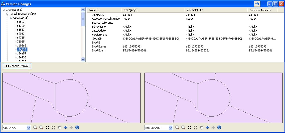
After making edits in a versioned featuredataset, the version changes tool lists 15 updates to the parcel feature class which was not edited. The parcel and zoning feature classes participate in a topology. The first of the 7 changes listed for parcel are miniscule changes in the shape area and lenght. I assume that this is an annoying side affect of topology. Even if we just split one zoning feature (note, no boundary shared with parcels is edited), then several parcel features that merely touch the split feature have their shapes updated by a miniscule amount. Is this a "feature" or a bug?
Secondly, I have 8 features in the feature class that was not edited that appear in the version changes tool as updates, but no change is highlighted. I understood from the version changes document help documen that at least one property should be printed as bold so you can see what attribute (or shape) was changed. Why would these be listed? See the attached image.
Finally, if I validate topolgy for the area, all topology errors that were marked as exceptions for any of the featues in all of the feature classes that participate in the topology that touch the split zoning feature are unmarked and I have to review them all again. Is this also a "feature"?
2 Replies
01-07-2014
07:44 AM
- Mark as New
- Bookmark
- Subscribe
- Mute
- Subscribe to RSS Feed
- Permalink
Did you find a solution to your problem?. I am having similar issues using the Version Changes Tool. We too use multiple topology rules with our SDE street centerline database. We maintain multiple polygon boundaries within the geodatabase. I keep seeing polygons showing up in Version Changes that do not show any "bold" fields. These are accumulating over time.
After making edits in a versioned featuredataset, the version changes tool lists 15 updates to the parcel feature class which was not edited. The parcel and zoning feature classes participate in a topology. The first of the 7 changes listed for parcel are miniscule changes in the shape area and lenght. I assume that this is an annoying side affect of topology. Even if we just split one zoning feature (note, no boundary shared with parcels is edited), then several parcel features that merely touch the split feature have their shapes updated by a miniscule amount. Is this a "feature" or a bug?
Secondly, I have 8 features in the feature class that was not edited that appear in the version changes tool as updates, but no change is highlighted. I understood from the version changes document help documen that at least one property should be printed as bold so you can see what attribute (or shape) was changed. Why would these be listed? See the attached image.
Finally, if I validate topolgy for the area, all topology errors that were marked as exceptions for any of the featues in all of the feature classes that participate in the topology that touch the split zoning feature are unmarked and I have to review them all again. Is this also a "feature"?
01-07-2014
07:55 AM
- Mark as New
- Bookmark
- Subscribe
- Mute
- Subscribe to RSS Feed
- Permalink
No I never did find a solution. I've asked a few Esri topology folks, and they say the version changes tool is not intended to be used with topology. Someone suggested Data Reviewer, but we don't have the budget for the additional extension, and one Esri employee told me that you would have the same problem.
The only partial workaround that we sometimes use when feasible is to have our tech make edits and before he/she validates topology we use the version changes tool to review the edits, then the tech validates topology, fixes any remaining errors if found, and then we post to the parent.
You say the changes are "accumulating over time". If you do a reconcile/post, then the two versions should be synchronous again, and you wouldn't see anything in the version changes tool until you start to edit again.