- Home
- :
- All Communities
- :
- Products
- :
- Data Management
- :
- Data Management Questions
- :
- Re: TRANSFORMATIONS AND PROJECTIONS
- Subscribe to RSS Feed
- Mark Topic as New
- Mark Topic as Read
- Float this Topic for Current User
- Bookmark
- Subscribe
- Mute
- Printer Friendly Page
- Mark as New
- Bookmark
- Subscribe
- Mute
- Subscribe to RSS Feed
- Permalink
Hello,
I am using ArcMap 10.3.
I selected the Projections and Transformations under Data Management Tools to change a NAD83 state plane coordinate to the WGS84 coordinate system. I filled-in the Output coordinate system and then the under the Z Coordinate System tab selected WGS 1984. Under the Environments tab I selected Z Values "same as input". I thought ArcMap would have created the new data to a vertical metric unit but the new data still has the US feet value. I noticed a past post states that only ArcMap 10.4 has the vertical projection capability. If this is the case, what is the "Z Coordinate System" tab for and is it possible to get my vertical elevation values projected from us feet to meters ?
Solved! Go to Solution.
Accepted Solutions
- Mark as New
- Bookmark
- Subscribe
- Mute
- Subscribe to RSS Feed
- Permalink
the attributes table won't change if the values are represented in the table. The only things that get updated in a featureclass table is when they are in a geodatabase and that would be shape_area and shape_length. If it isn't in a geodatabase,then nothing gets changed
- Mark as New
- Bookmark
- Subscribe
- Mute
- Subscribe to RSS Feed
- Permalink
There is the vertical datum and then in the reference for the project tool which notes the caveat.
To perform a vertical transformation, check the optional Vertical parameter on the dialog. By default, the Vertical parameter is disabled and is only enabled when the input and output coordinate systems have Vertical Coordinate System, and the input feature class coordinates have Z values. Also, additional data (Coordinate Systems Data) setup needs to be installed on the system
- Mark as New
- Bookmark
- Subscribe
- Mute
- Subscribe to RSS Feed
- Permalink
Dan,
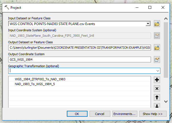
I am not getting the Vertical Parameter button. Below is a screen capture of my project dialog for reference. Perhaps I am missing something or do not have the correct version of ArcMap ?
- Mark as New
- Bookmark
- Subscribe
- Mute
- Subscribe to RSS Feed
- Permalink
as it says in the quote, they are both the same, so you shouldn't see it at all... and you should really scroll down further in the dialog to make sure you see everything just in case...
- Mark as New
- Bookmark
- Subscribe
- Mute
- Subscribe to RSS Feed
- Permalink
Dan,
Ok, if I understand, my project tab "Z Coordinate System" found when populate Output Coordinate System (see screen shot below), is the same as the "Vertical Parameter Button" you are referring ? If I am correct, my elevation values are not changing from feet to meters. I have an elevation, for example of 25.36', that value persists after the transformation (SC Nad83 Intl ft to WGS84 m). What else am I likely missing ?

- Mark as New
- Bookmark
- Subscribe
- Mute
- Subscribe to RSS Feed
- Permalink
this seems to be an event layer and not a z-enabled featureclass, so all bets are off. Values in a field/table won't be updated in any event. I would make a featureclass from it first before worrying about projecting.
- Mark as New
- Bookmark
- Subscribe
- Mute
- Subscribe to RSS Feed
- Permalink
Dan,
In arc catalog I created a file database, then imported my points into the database as a feature class. Then I ensured the feature class had a Z coordinate to start with (NAVD88). Then I performed the transformation/projection from NAD83 Intl Feet to WGS84 meters. The XY appeared to change properly to WGS84 but the Z values were still showing feet values. What am I likely doing wrong if I want to get meters as my Z values, assuming it is possible?
- Mark as New
- Bookmark
- Subscribe
- Mute
- Subscribe to RSS Feed
- Permalink
This is the only thing I can find for 3d features http://desktop.arcgis.com/en/arcmap/latest/tools/data-management-toolbox/adjust-3d-z.htm and again, it won't change z values in a table, those have to be done via a field calculator or other means
- Mark as New
- Bookmark
- Subscribe
- Mute
- Subscribe to RSS Feed
- Permalink
Dan,
Thanks for that feedback. So if I understand correctly, the actual units will not update, but the Z-Coordinate I selected will update which proves to be the case per my example project. If I "transform from a state plane system such as NAD83, to a geographic system such as wgs84, that involves both a transformation and a projection. Am I correct to assume that is the case ?
- Mark as New
- Bookmark
- Subscribe
- Mute
- Subscribe to RSS Feed
- Permalink
check your layer in Properties and see if if hasZ is True if it doesn't then your coordinates were 2D otherwise 3D and you would want them adjusted