- Home
- :
- All Communities
- :
- Products
- :
- Data Management
- :
- Data Management Questions
- :
- Re: spatial view - FC and table with 1:M
- Subscribe to RSS Feed
- Mark Topic as New
- Mark Topic as Read
- Float this Topic for Current User
- Bookmark
- Subscribe
- Mute
- Printer Friendly Page
- Mark as New
- Bookmark
- Subscribe
- Mute
- Subscribe to RSS Feed
- Permalink
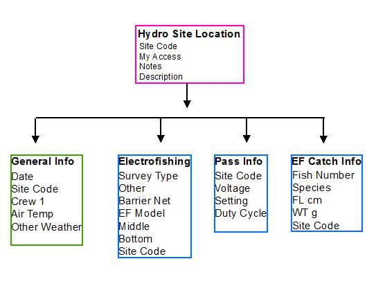
We perform stream surveys on the same site on a yearly basis. I included a basic diagram of how our data structure looks. Because we perform the survey on the same sites there is a 1:M relationship between the FC and each table (sitecode is the unique identifier). The main reason for this structure is to support our mobile data collection effort. We are using the Collector app; the data is hosted on our ArcGIS Server and added to AGOL.
I have tried to create a basic spatial view, but the only way I was to accomplish this was using a table that did not have a relationship class to the FC, I have done some reading online but have been getting a little overwhelmed!
So, I would like to create a spatial view that shows our sample location with attributes from all four tables; this was a request from the user that will be performing queries and generating reports from this data.
If it is not possible to create a spatial view, would it be possible to create a view of all four non-spatial tables then create a 1:M to the FC??
I am using ArcGIS 10.2.2 and all tables are versioned in an sde gbd. If any other informaiton is pertinet to identifying a solution please let me know!
Thank you!
Solved! Go to Solution.
Accepted Solutions
- Mark as New
- Bookmark
- Subscribe
- Mute
- Subscribe to RSS Feed
- Permalink
Is your data stored in a geodatabase you could Make Query Table—Help | ArcGIS for Desktop
- Mark as New
- Bookmark
- Subscribe
- Mute
- Subscribe to RSS Feed
- Permalink
Is your data stored in a geodatabase you could Make Query Table—Help | ArcGIS for Desktop
- Mark as New
- Bookmark
- Subscribe
- Mute
- Subscribe to RSS Feed
- Permalink
Here's a technical article on Make Query Table - 37544 - Create a one-to-many join in ArcMap
- Mark as New
- Bookmark
- Subscribe
- Mute
- Subscribe to RSS Feed
- Permalink
Thank you, I will take a look at these articles. I am also working with ESRI, so if we come across a solution I will post the solution 
- Mark as New
- Bookmark
- Subscribe
- Mute
- Subscribe to RSS Feed
- Permalink
I did end up creating a Query Table!
In the event someone else is looking for a solution I will comment on my problem.
Basically the issue was my data had GlobalID's and domains. Once the Global ID's were removed I was able to create the spatial view, but the attributes were wrong. As I learned from ESRI, the spatial view is created at the database level so domains were not supported.