- Home
- :
- All Communities
- :
- Products
- :
- Data Management
- :
- Data Management Questions
- :
- Re: snap not working while georeferencing cad
- Subscribe to RSS Feed
- Mark Topic as New
- Mark Topic as Read
- Float this Topic for Current User
- Bookmark
- Subscribe
- Mute
- Printer Friendly Page
snap not working while georeferencing cad
- Mark as New
- Bookmark
- Subscribe
- Mute
- Subscribe to RSS Feed
- Permalink
Hello,
I have a rather simple CAD file with new parcel information and am trying to incorporate it into an existing map. When I choose the Add Control Points option, I cannot get the snapping function to work. Is this a known issue or anyone know of a fix?
I only brought in the polylines from CAD and have that selected in the Georeferencing dropdown. Snapping toolbar is turned on and shows Endpoints and Intersections should be turned on. The map file does not have a huge number of layers in it and most except those that I am using are turned off. What am I missing? Is this a known issue and is there a fix?
Thanks in advance for any info and insights.
Lana
- Mark as New
- Bookmark
- Subscribe
- Mute
- Subscribe to RSS Feed
- Permalink
well there is snapping and classic snapping, so I will defer to the help file and its description and images since no one else has weighed in
About snapping—Help | ArcGIS for Desktop
About the editing classic snapping environment—Help | ArcGIS for Desktop
- Mark as New
- Bookmark
- Subscribe
- Mute
- Subscribe to RSS Feed
- Permalink
Thank you, Dan.
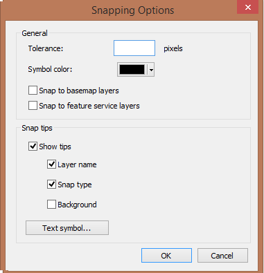
I did read this article, but from what I understand the snapping toolbar should still work during georeferencing whether classic snapping is turned on or off. I tried turning classic on just to see, but it made no difference. I’ve also adjusting the snapping tolerances (from the toolbar, options) from 1 to 50 pixels and that didn’t help either.
I am getting the long lag time and blue spinning circle I have heard other people talk about, but removing layers and simplifying everything (both in GIS and the CAD file) has also not worked. I’m out of ideas and not much comes up when searching in GeoNet, other forums, and google.
- Mark as New
- Bookmark
- Subscribe
- Mute
- Subscribe to RSS Feed
- Permalink
I dont work with cad, and it has been a long time since I had to 'fix' something, but you refer to georeferencing, which to me is an image thing whereas 'spatial adjustment' seems to be an esri parlance thing so I am wonder if there is something I am not getting or the environment parameters are different, ... in any event, this is to what I refer About spatial adjustment—Help | ArcGIS for Desktop
- Mark as New
- Bookmark
- Subscribe
- Mute
- Subscribe to RSS Feed
- Permalink
I am just learning GIS/CAD interoperability as well, but took an ESRI instructor led course on it back in November. The workbook and exercises we used definitely used georeferencing and snaps after bringing in CAD polylines in order to reposition them. I have gone back to review those materials about a dozen times, but no clues to the problem I’m having were found.
It does seem like there is something wrong with the ArcGIS functionality. I started this project by following those ESRI instructions precisely, but the functions they reference just aren’t working. Only difference is 10.3 to 10.4 version, since I have upgraded since then, but nothing in the reading I did about “What’s new for 10.4” mentions these issues either.
Sigh. Work around it is. I just began reading about spatial adjustment and converted my CAD lines to a shapefile so I could try this route.
- Mark as New
- Bookmark
- Subscribe
- Mute
- Subscribe to RSS Feed
- Permalink
You don't mention which Arc version you are on - 10.x ? Pro ?
The snapping features, what are they and where do they come from (enterprise geodb, fgdb, shape?)
I have had difficulties in the past with sometimes snapping (the auto version) not working properly with various enterprise hosted features, but that was solved by resorting to classic snapping where you actually specified what features were turned on for snapping.
Is the CAD file already properly georeferenced and has a defined coordinate system?
Or is this part of the georeferencing process - spatial adjustment?
- Mark as New
- Bookmark
- Subscribe
- Mute
- Subscribe to RSS Feed
- Permalink
Thanks, Neil. I’m using ArcGIS 10.4, no Enterprise or Pro. I’m using the snapping toolbar, as classic is only an option within an editing environment from what I understand. The CAD file has a coordinate system that was assigned in Civil 3D, and also in ArcCatalog. It comes in very close and at the right scale, so these are minor adjustments to align with the existing parcel info. Here’s a screenshot
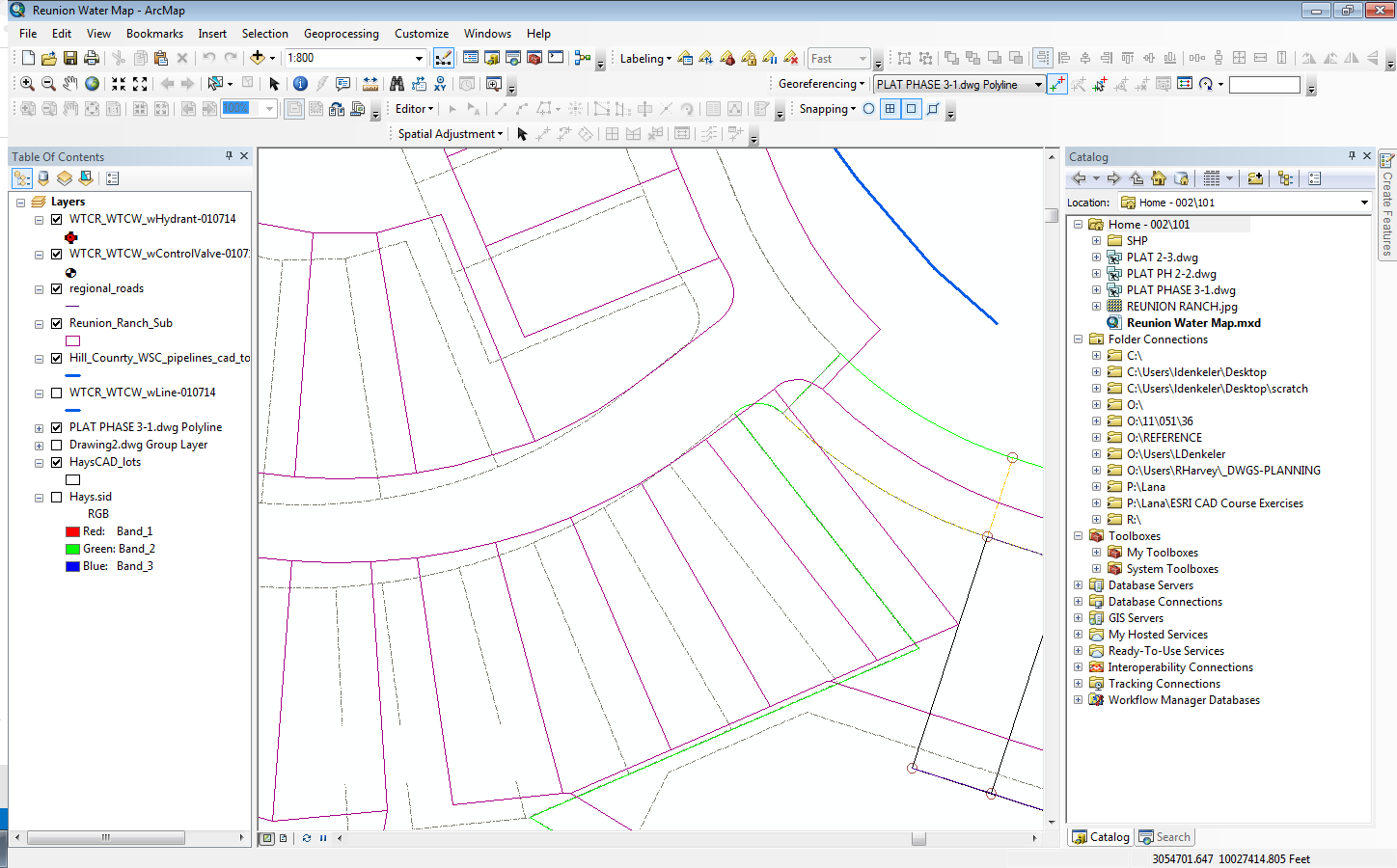
- Mark as New
- Bookmark
- Subscribe
- Mute
- Subscribe to RSS Feed
- Permalink
So, you are not georeferencing the CAD file, just spatially adjusting it?
Is this just a portion of you data, because it looks like you have all those lots already in your main feature?
- Mark as New
- Bookmark
- Subscribe
- Mute
- Subscribe to RSS Feed
- Permalink
When I created the thread I was only georeferencing. And, yes, the screenshot is only a portion of the data. Some of the data overlaps, and I’m using those areas to set my control points from the new parcel information to the existing data. I figured I can delete any duplicate lines after I get the data in there. I was zoomed into what I was working on when I took the screenshot image.
However, I have since just lifted the CAD lines I want to work with and created a new shapefile. I spent half a day troubleshooting the snap functionality, so am now attempting to do a spatial adjustment for the first time. Snapping works in this second instance, since to do a spatial adjustment you have to have an active editing session. Again, from what ESRI was teaching us 6 months ago, the snapping toolbar should have also worked during georeferencing.
- Mark as New
- Bookmark
- Subscribe
- Mute
- Subscribe to RSS Feed
- Permalink
After you Add CAD File. Export each layer to shape file or feature class.
If cad file use real coordinate . you should define projection only .
if Cad file not. you will define projection also, but after that you will use Spatial Adjustment.
About snapping:
Try to increase Tolerance in Snapping options.
Notice
- You can't edit CAD files in Arc map without export it to shape file or feature class.
- Georeference for Raster.
- Spatial Adjustment for Vector.