- Home
- :
- All Communities
- :
- Products
- :
- Data Management
- :
- Data Management Questions
- :
- Re: Reprojection and comparison of data
- Subscribe to RSS Feed
- Mark Topic as New
- Mark Topic as Read
- Float this Topic for Current User
- Bookmark
- Subscribe
- Mute
- Printer Friendly Page
Reprojection and comparison of data
- Mark as New
- Bookmark
- Subscribe
- Mute
- Subscribe to RSS Feed
- Permalink
Hi
I would like to seek help in projecting my data to UTM WGS 1984.
DTM attached is in TIF file extracted from WorldDTM with GCS WGS 1984 projection while the other one is in shapefile extracted from CAD data (actual ground survey data) with PTM PRS 92 projection.
i followed the basic steps in reprojecting data but unfortunately i cannot execute it in the right way that it should be projected.
one of my objective is to convert the Shapefile to raster data so i can compare and calculate the difference of elevation in meters of these 2 topographic data.
Please help me on this matter. Attached is my data for reference.
Thank You!
https://community.esri.com/groups/geodatabase?sr=search&searchId=a6c4556b-cf01-4208-8eb8-702bc728aeb... https://community.esri.com/community/gis/enterprise-gis?sr=search&searchId=bbbdac94-91cd-4035-b1a3-4... https://community.esri.com/groups/coordinate-reference-systems?sr=search&searchId=85a68742-93be-4a70... https://community.esri.com/groups/technical-support?sr=search&searchId=b3e56eb1-16be-4f3a-a6da-fc0de... https://community.esri.com/groups/map-projections?sr=search&searchId=f695d96d-c624-446a-9cc2-5d26347...
- Mark as New
- Bookmark
- Subscribe
- Mute
- Subscribe to RSS Feed
- Permalink
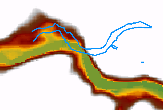
Back in ArcMap, looking at the contour data with the online background imagery...
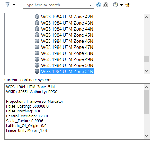
Changed the coord sys of the frame to :
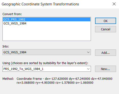
Using this transformation :
Doesn't really fit with the imagery very well. But at this scale (quite large)...
- Mark as New
- Bookmark
- Subscribe
- Mute
- Subscribe to RSS Feed
- Permalink
When I overlay the river with the DEM you can see that it does not match at all.
Perhaps if the vector layer is flipped horizontally and vertically, rotated and perhaps enlarged is may come a bit closer, but you shouldn't do that:
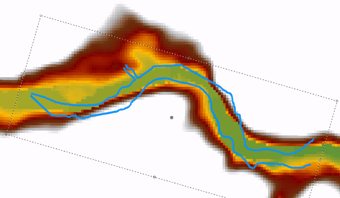
This may be related to the coordinate system of one or both of the inputs and interpolate the contour lines followed by comparing both sources would not make much sense, since this will generate huge differences due to the mismatch of location.
- Mark as New
- Bookmark
- Subscribe
- Mute
- Subscribe to RSS Feed
- Permalink
Based on your output, what seems to be the problem? Is it the projection of DEM or the ground survey which is in shapefile?
For me it is difficult to compare these 2 since they have different baseline data, i mean different reference point.
Am I right?
- « Previous
-
- 1
- 2
- Next »
- « Previous
-
- 1
- 2
- Next »