- Home
- :
- All Communities
- :
- Products
- :
- Data Management
- :
- Data Management Questions
- :
- Re: Reprojection and comparison of data
- Subscribe to RSS Feed
- Mark Topic as New
- Mark Topic as Read
- Float this Topic for Current User
- Bookmark
- Subscribe
- Mute
- Printer Friendly Page
Reprojection and comparison of data
- Mark as New
- Bookmark
- Subscribe
- Mute
- Subscribe to RSS Feed
- Permalink
Hi
I would like to seek help in projecting my data to UTM WGS 1984.
DTM attached is in TIF file extracted from WorldDTM with GCS WGS 1984 projection while the other one is in shapefile extracted from CAD data (actual ground survey data) with PTM PRS 92 projection.
i followed the basic steps in reprojecting data but unfortunately i cannot execute it in the right way that it should be projected.
one of my objective is to convert the Shapefile to raster data so i can compare and calculate the difference of elevation in meters of these 2 topographic data.
Please help me on this matter. Attached is my data for reference.
Thank You!
https://community.esri.com/groups/geodatabase?sr=search&searchId=a6c4556b-cf01-4208-8eb8-702bc728aeb... https://community.esri.com/community/gis/enterprise-gis?sr=search&searchId=bbbdac94-91cd-4035-b1a3-4... https://community.esri.com/groups/coordinate-reference-systems?sr=search&searchId=85a68742-93be-4a70... https://community.esri.com/groups/technical-support?sr=search&searchId=b3e56eb1-16be-4f3a-a6da-fc0de... https://community.esri.com/groups/map-projections?sr=search&searchId=f695d96d-c624-446a-9cc2-5d26347...
- Mark as New
- Bookmark
- Subscribe
- Mute
- Subscribe to RSS Feed
- Permalink
You have a number of issues with your data:
- The shapefile with the contour lines has a geographic coordinate system defined (coordinates in decimal degrees), however the data really has projected coordinates. It is important to know what the correct coordinate system of this data is and assign that correct coordinate system before you proceed.
- The other aspect is that the contour lines, are a result of some cartographic processing (Cul-de-Sac masking). It has holes in the major contour lines. You would need to correct this before interpolation (see Topo to Raster—Help | ArcGIS Desktop, Spatial Analyst or 3D Analyst required):

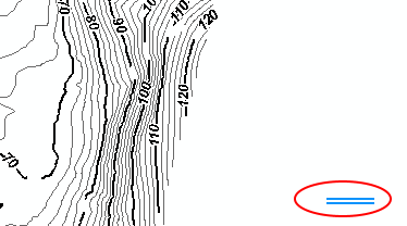
- I also found some residue of the legend in the lower right corner of you contour shapefile:
After you have assigned the correct projection Define Projection—Help | ArcGIS Desktop and have reprojected the data to be in the same projection as the DEM ( Project—Help | ArcGIS Desktop ) you can interpolate the contours Topo to Raster—Help | ArcGIS Desktop and calculate the difference between both DEM's Minus—Help | ArcGIS Desktop
- Mark as New
- Bookmark
- Subscribe
- Mute
- Subscribe to RSS Feed
- Permalink
ok thank you Mr Xander, i'll clean the data first.
- Mark as New
- Bookmark
- Subscribe
- Mute
- Subscribe to RSS Feed
- Permalink
Do you have any idea on what the correct projection for the contour lines might be?
- Mark as New
- Bookmark
- Subscribe
- Mute
- Subscribe to RSS Feed
- Permalink
Based on the lay out of CAD file, it is in PRS 92
- Mark as New
- Bookmark
- Subscribe
- Mute
- Subscribe to RSS Feed
- Permalink
Here's the screen shot of the CAD file legend

- Mark as New
- Bookmark
- Subscribe
- Mute
- Subscribe to RSS Feed
- Permalink
Just looked up that PRS## is for the Philippines. And it is based on the Luzon datum.
There are several zones with their own central meridians. So you need to know which zone.
And use the correct transformation between Luzon and WGS.
Too much detail I'm sure....
- Mark as New
- Bookmark
- Subscribe
- Mute
- Subscribe to RSS Feed
- Permalink
It falls within PRS Zone 4
- Mark as New
- Bookmark
- Subscribe
- Mute
- Subscribe to RSS Feed
- Permalink
I'm sorry it's zone 3
- Mark as New
- Bookmark
- Subscribe
- Mute
- Subscribe to RSS Feed
- Permalink
So currently the contour shapefile coord sys is defined like this :
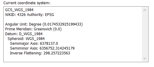
But you can see from the extent tab, that this cannot be true.
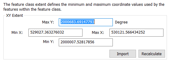
Those numbers don't look like decimal degrees to me (too big).
So, redefine it like this:
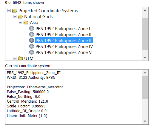
Right click on the shapefile in Catalog (don't have it open in ArcMap at the same time).
Use the search to find "PRS", in projected coordinate systems.