Turn on suggestions
Auto-suggest helps you quickly narrow down your search results by suggesting possible matches as you type.
Cancel
- Home
- :
- All Communities
- :
- Products
- :
- Data Management
- :
- Data Management Questions
- :
- Re: Raster to Polygon problem
Options
- Subscribe to RSS Feed
- Mark Topic as New
- Mark Topic as Read
- Float this Topic for Current User
- Bookmark
- Subscribe
- Mute
- Printer Friendly Page
Raster to Polygon problem
Subscribe
17705
17
01-28-2013 05:50 AM
01-28-2013
05:50 AM
- Mark as New
- Bookmark
- Subscribe
- Mute
- Subscribe to RSS Feed
- Permalink
Thanks in advanced.
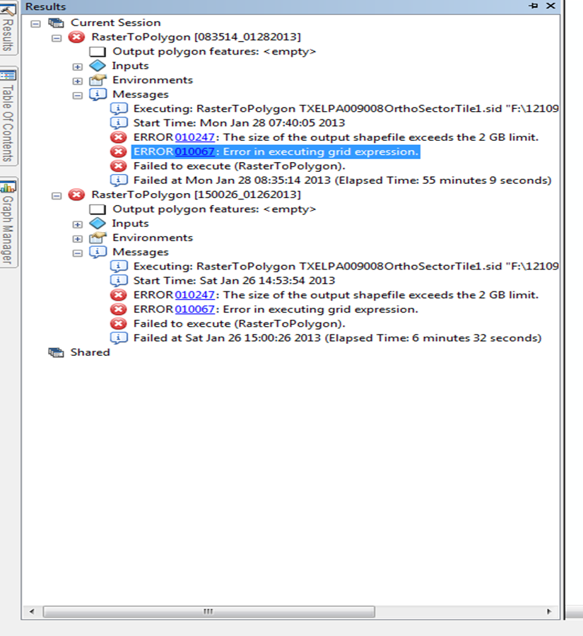
I have over 100 aerials images that I want to convert to polygons using the raster to polygon tool, but I get an error for this tool [ATTACH=CONFIG]21130[/ATTACH].
All I want to do is to create a base map so that I know which aerial refers to specific area and be able to find it easily.
NOTE: Only have basic license, unfortunately.
17 Replies
01-28-2013
05:57 AM
- Mark as New
- Bookmark
- Subscribe
- Mute
- Subscribe to RSS Feed
- Permalink
The critical error is the one above the highlighted error...your file is too big and the output shapefile is limited to 2 GB and cannot be created. There is no workaround other than tiling your input file.
01-28-2013
06:19 AM
- Mark as New
- Bookmark
- Subscribe
- Mute
- Subscribe to RSS Feed
- Permalink
Mr. Patterson,
I was just doing the tool for one tile.
I am attaching the properties for one of the files [ATTACH=CONFIG]21131[/ATTACH].
I am also choosing the simplify shape.
The other error is that I am not using an adequate type of file. I been checking for many ways to fix this but with no luck.
I am not even able to give coordinates to all the file using the define projection tool in a batch mode.
Thanks again.
01-28-2013
06:57 AM
- Mark as New
- Bookmark
- Subscribe
- Mute
- Subscribe to RSS Feed
- Permalink
It is the output polygon shapefile that is too big. There is a 2 GB limit which is being exceeded.
01-28-2013
10:21 AM
- Mark as New
- Bookmark
- Subscribe
- Mute
- Subscribe to RSS Feed
- Permalink
I am fairly new to GIS, you know of a way that I can make the tiles smaller so that I can do this export.
Or is there a way to be able to touch the aerial and copy/paste the polygon shape that it has.
Or is there a way to be able to touch the aerial and copy/paste the polygon shape that it has.
01-29-2013
06:37 AM
- Mark as New
- Bookmark
- Subscribe
- Mute
- Subscribe to RSS Feed
- Permalink
In versions prior to ArcGIS 10 we wrote the output to .shp and then converted to whatever format you wanted. However, from ArcGIS 10 we natively write to the requested format.
Therefore, if you're using ArcGIS 10+ you can output to file geodatabase and you won't hit the 2.1GB file limit.
Regards
Steve
Therefore, if you're using ArcGIS 10+ you can output to file geodatabase and you won't hit the 2.1GB file limit.
Regards
Steve
01-29-2013
08:56 AM
- Mark as New
- Bookmark
- Subscribe
- Mute
- Subscribe to RSS Feed
- Permalink
Thanks so much Steve,
Now the problem is that the table was created successfully but I cannot find it at the location that it was send to..
it does not appear in the geodatabase.
I already try several ways, the arc catalog, refreshing, closing the file and opening again.
Is there another way to do what the footprint from mosaic tool does but with the license that I currently have?[ATTACH=CONFIG]21165[/ATTACH]
01-29-2013
09:33 AM
- Mark as New
- Bookmark
- Subscribe
- Mute
- Subscribe to RSS Feed
- Permalink
Hi,
Are you saying the output polygon featureclass that was created as a result from the raster to polygon tool is missing in the file geodatabase? May be your geodatabase got corrupted, try to make a copy of your geodatabase in another folder location and see if the output is visible there.
Thanks,
Gayathri A.
01-29-2013
02:10 PM
- Mark as New
- Bookmark
- Subscribe
- Mute
- Subscribe to RSS Feed
- Permalink
Thanks to everyone that has been giving input,
I tried already changing the output database. but still it will not appear.
This is the process that I follow.
I open the raster to polygon tool, put in input raster, keep the value field, select the gdb file to output, and have simplify checked.
After this click OK, and in less than 5 sec. it will tell me that succeeded using the tool.
You can see the location of the file in the results window, but when the gdb is open there is nothing in there.
01-29-2013
02:51 PM
- Mark as New
- Bookmark
- Subscribe
- Mute
- Subscribe to RSS Feed
- Permalink
I noticed in your original post you said:
"All I want to do is to create a base map so that I know which aerial refers to specific area and be able to find it easily."
So, in that case, wouldn't simple polys built from X and Y min/max coordinates work? If so, see:
looping through rasters in an mxd
http://forums.arcgis.com/threads/75142-looping-through-rasters-in-an-mxd?p=265602#7
Rosie Bell has updated the pre-10 code to use arcpy - I'd recommend building the feature class in a table, so change pathnames accordingly. Otherwise you build a shapefile but you'll likely have to remember to build the spatial index for large layers. Also, I think my original code simply builds from a designated directory of rasters. Apologize for not making this a script tool (or maybe someone has already?) but I only use this occasionally - once on thousands of tifs that I assumed the run failed for, but it completed successfully to my surprise. Anyway, what I mean to say is that it is lightning fast with python.
One more interesting thing, if you've ever heard of a 'table-based' image catalog, additionally if you export the attribute table to an independent table (gdb table or dbf table), it becomes readable by ArcGIS as an image catalog... this is legacy support still available at 10.1 I believe, and what it serves as is to auto-load image tiles in the view extent (or a certain scale threshold, if you set the layer properties).
Enjoy,
Wayne