- Home
- :
- All Communities
- :
- Products
- :
- Data Management
- :
- Data Management Questions
- :
- Re: Raster Mosaic Dataset with Overviews: setting ...
- Subscribe to RSS Feed
- Mark Topic as New
- Mark Topic as Read
- Float this Topic for Current User
- Bookmark
- Subscribe
- Mute
- Printer Friendly Page
Raster Mosaic Dataset with Overviews: setting MinPS and MaxPS
- Mark as New
- Bookmark
- Subscribe
- Mute
- Subscribe to RSS Feed
- Permalink
Hello fellow ESRI Users.
Oracle 11.2, SDE 10.2.2, ArcMap 10.2.2
Recently, I have been experimenting with Raster Mosaic Datasets with Overviews and I am trying to understand the relationship between MINPS/MAXPS and scale. I have read the ESRI documentation:
http://resources.arcgis.com/en/help/main/10.2/index.html#/na/009t00000040000000/
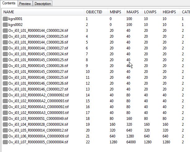
Hopefully you can view the attached jpg.
Here the first two Images kgrs0001 and kgrs0002 are the original tifs - the rest being the Overviews generated by taking the Default Settings in the ESRI Tools.
Question 1: Is the MINPS and MAXPS calculated incorrect? I assume 0 - 20 would be better than 0 - 100? And I should use the "calculate cell size ranges" tool?
Question 2: Follow on from 1, in the MINPS and MAXPS columns there should be no overlaps of values i.e 0 - 20, 20 -40, 40 -80 etc - correct?
Question 3: I know the equation about calculating the cell size to scale when viewed in ArcMap. If in the attached example - if I zoom in with ArcMap to a scale of 1:1000 I assume I am viewing the original tifs - is there anyway of checking if I am using orginal tif or overview?
Question 4: if we only view the data at 1:1000 scale - there is no need to build overviews?
Hopefully someone can help my understanding further.
Kind Regards
Nicholas
- Mark as New
- Bookmark
- Subscribe
- Mute
- Subscribe to RSS Feed
- Permalink
Hi Nicholas,
1. 0 - 100 represents the scale at which the original TIFFs will display without overviews. So, assuming your projection is in meters, if Overviews were not built you would be able to view the mosaic dataset at a scale no smaller than 377,952. For example, if you zoomed to 378,000 the mosaic dataset would not display.
2. It is fine if these values overlap.
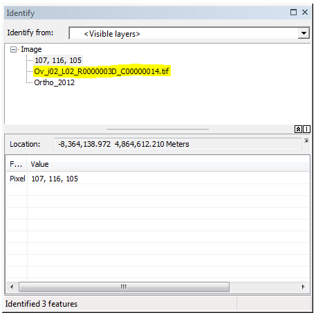
3. If you identify the mosaic dataset, you should not have an overview listed in the identify window for visible layers if the original TIFFs are being accessed:
4. Yes, if you are only viewing the imagery at large scales, you do not need to build overviews.
- Mark as New
- Bookmark
- Subscribe
- Mute
- Subscribe to RSS Feed
- Permalink
Hi Jake
Firstly, thank you for your answers to date - very help. After a week or so to test and think about what you said I have a follow up question to:
>> 4. Yes, if you are only viewing the imagery at large scales, you do not need to build overviews.
In our organisation, our 4 band Aerial photos (tifs) are stored on the file system. I create the Raster Mosaic in Oracle / SDE 10.2.2. - add the rasters from the file system - using a unc path - then I define the overviews to be generated in a folder called "overviews" also on the file system with a unc defined path. This works ok.
My question is for opitimal performance for our users using ArcMap connecting via SDE - would it be best that the original tifs are stored in the smallest file size possible?
What am I trying to say for example is it better to have 1)1000 x 1 MB tifs or 2) 100 x 10MB tifs or 3) does not matter?
- Mark as New
- Bookmark
- Subscribe
- Mute
- Subscribe to RSS Feed
- Permalink
Hi
As far as I know the idle size for the original data is just like the default size of overviews tile – it is 5120X5120 (5kX5k)
This is small file on disk spatially if you use compressed tiff.
Have fun
- Mark as New
- Bookmark
- Subscribe
- Mute
- Subscribe to RSS Feed
- Permalink
Hello Jake.
Great. Thank you very much for the answer. Much appreciated.
Just to confirm in my mind Point 4.
If I had 3 separate raster itf data with a cell size of 0.25, 1 or 10
(0.25 * 96 / 0.0254=944.8) = 1:944.8
(1 * 96 / 0.0254=3779.5) = 1:3779.5
(10 * 96 / 0.0254=37795) = 1:37795
Then for example 0.25 cell size, if in ArcMap, I only view the data less than 1:900, I do not need to build overviews?
- Mark as New
- Bookmark
- Subscribe
- Mute
- Subscribe to RSS Feed
- Permalink
You will want to base this off of the MaxPS rather than the actually cell size of the raster dataset. From the help:
The LowPS and HighPS values are calculated based on the source raster resolution, the pyramid levels, and also the settings in Raster Pyramid Options when using the Add Rasters To Mosaic Dataset tool. For example, a raster dataset that contains cells of 1 meter and a pyramid with cell sizes of 2, 4, 8, and 16 meters would have a LowPS of 1 and a HighPS of 16 if all the pyramid levels are used. If you set the Maximum Cell Size to 8 in the Raster Pyramid Options, the HighPS will be 8 instead of 16.
- MaxPS is equal to 10 times the HiPS.
- MinPS is equal to the minimum visibility of the raster, which is usually the LoPS.
So if the MaxPS was 200, the max scale to view the mosaic dataset without Overviews would be:
(200 * 96) / 0.0254 = 755,905
- Mark as New
- Bookmark
- Subscribe
- Mute
- Subscribe to RSS Feed
- Permalink
Hello Jake and fellow GIS Users
Sorry to use a very simple example but I am trying to get my head around these Raster Mosaic Datasets - when all was in Oracle it was easy 😉
Example:
if I have 100 100MB 3-band tifs stored on the file system. So a 10 by 10 Matrix.
When a user using ArcMap zooms in to a 1:100 scale they will be using the orginial tifs based on MaxPS. All ok.
Here's my dumb question - if they zoom into an area where 4 tifs join are they:
[1] accessing 4 x 100MB of data over the network or [2] does ArcMap optimise the Information they require from the 4 tifs and return only a fraction of the 4 x 100MB?