- Home
- :
- All Communities
- :
- Products
- :
- Data Management
- :
- Data Management Questions
- :
- Re: Projection Issues (Converting from UTM Zone 44...
- Subscribe to RSS Feed
- Mark Topic as New
- Mark Topic as Read
- Float this Topic for Current User
- Bookmark
- Subscribe
- Mute
- Printer Friendly Page
Projection Issues (Converting from UTM Zone 44N to Kandawala SriLanka Grid) shifting around 200 meters in the easting
- Mark as New
- Bookmark
- Subscribe
- Mute
- Subscribe to RSS Feed
- Permalink
Hi,
I am from Sri Lanka. Northern Sri Lanka is in UTM Zone 44. If the data been collected in UTM Zone 44N and If I (or someone) convert it to Kandawala Sri Lankan Grid (Available in ArcGIS 10.1 as Projected Coordinate Systems -> National Grids -> Asia -> Kandawala Sri Lanka Grid) there seems to be shifting around 200 meters on the east. However if I use DNR GPS software from DNRGPS Application: Minnesota DNR load the shape file then if I set (from the DNR GPS) the file -> Set Projections -> Datum as Kandawala and Projection as Sri Lankan Grid only few meter difference which is acceptable. I have verfied this with 2 Garmin GPS one set to UTM Zone 44n and other set to Sri Lankan Grid . I shall be thankful if I can sort out the issue in ArcGIS.
- Mark as New
- Bookmark
- Subscribe
- Mute
- Subscribe to RSS Feed
- Permalink
This type of shift is normally associated with a datum shift. Are you sure that the datums are the same?
- Mark as New
- Bookmark
- Subscribe
- Mute
- Subscribe to RSS Feed
- Permalink
Dear Dan Patterson,
No. The datum UTM Zone 44n is WGS84 while for Kandawala Sri Lankan Grid Datum is Kandawala. Geotrans software NGA: (U) MSP GEOTRANS 3.4 Geographic Translator (UNCLASSIFIED) also provide resonably accurate transformation.
- Mark as New
- Bookmark
- Subscribe
- Mute
- Subscribe to RSS Feed
- Permalink
Did you set a transformation (datum shift) under the cords tab in the data frame properties page?
You have a single geocentric transform available (ArcGIS v10.2) for WGS84 to/from Kandawala, dx, dy, dz parameters -97.0, 787.0, 86.0.
That will be the likely cause of your 200m shift.
Neil
- Mark as New
- Bookmark
- Subscribe
- Mute
- Subscribe to RSS Feed
- Permalink
Dear Neil Ayres,
Many thanks for the reply. You may have a look at the original gpx via https://onedrive.live.com/embed?cid=45B0A8A523ED0470&resid=45B0A8A523ED0470%21585&authkey=ADgKMvA2w_... file from the garmin etrex10 GPS (with GLONASS enabled) that can easily open dnr gps and save as a a arcgis shaefile from there.
I set the data frame properties to Kandawala Sri Lankan Grid
I have added the layer which was set at UTM Zone 44n with WGS 84datum.
When I added it gave Grographic Coordinate System Warning which is given below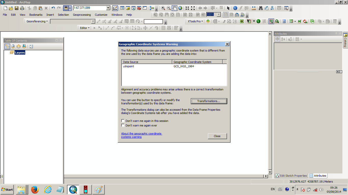
I have clicked the Transformation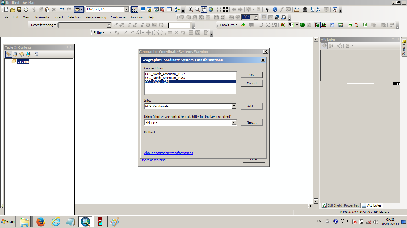
If I simply click Convert from GCS_WGS_1984 to GCS_Kandawla and click ok results around 200m shifting in the east as I mentioned via a screenshot above. However if I choose using (choices are sorted by suitability for the layer's extent) using geocentric transoformation geocentric transformation it works and the answer is quite close. 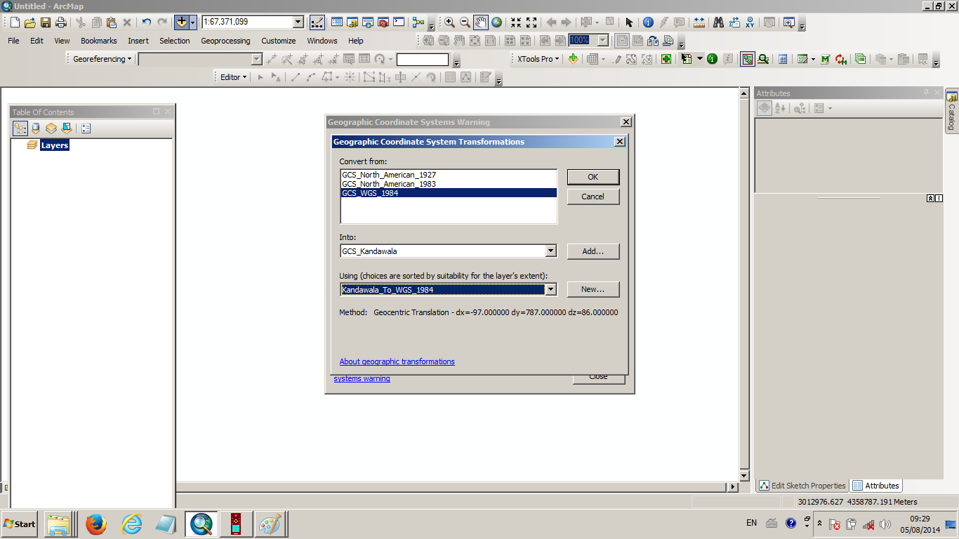
- Mark as New
- Bookmark
- Subscribe
- Mute
- Subscribe to RSS Feed
- Permalink
Rangunathan,
exactly,
you have to chose the correct transformation.
If this is has answered your problem, please mark the post as such.
N
- Mark as New
- Bookmark
- Subscribe
- Mute
- Subscribe to RSS Feed
- Permalink
I've moved your post into the GIS Mapping Data space. GeoNet Help is intended for discussion on the community help and feedback. I have also added in a few additional tags. You can see more on the community structure, and what topics are under each space from the
following documents:
ArcGIS Discussion Forums Migration Strategy
Thanks!
Don