Turn on suggestions
Auto-suggest helps you quickly narrow down your search results by suggesting possible matches as you type.
Cancel
- Home
- :
- All Communities
- :
- Products
- :
- Data Management
- :
- Data Management Questions
- :
- Re: Projecting multiple images from one coordinate...
Options
- Subscribe to RSS Feed
- Mark Topic as New
- Mark Topic as Read
- Float this Topic for Current User
- Bookmark
- Subscribe
- Mute
- Printer Friendly Page
Projecting multiple images from one coordinate system to another,
Subscribe
by
Anonymous User
Not applicable
09-26-2013
10:42 AM
- Mark as New
- Bookmark
- Subscribe
- Mute
- Subscribe to RSS Feed
- Permalink
- Report Inappropriate Content
Original User: Jamal432@gmail.com
Projecting multiple images from one coordinate system to another,
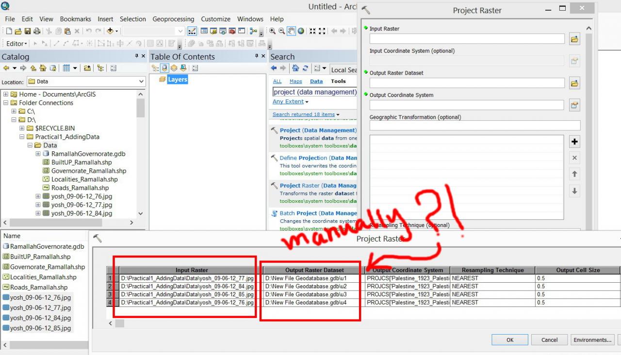
I wanted to project multiple Jpeg images form Israel to Palestine coordinate system using the batch of the ???project raster??? tool but couldn???t figure out how the input raster are populated automatically in the ???output raster dataset???
[ATTACH=CONFIG]27794[/ATTACH], [ATTACH=CONFIG]27795[/ATTACH]
Is there a way to populate the images automatically in the ???output raster dataset????
Thank you
Best
Jamal
Projecting multiple images from one coordinate system to another,
I wanted to project multiple Jpeg images form Israel to Palestine coordinate system using the batch of the ???project raster??? tool but couldn???t figure out how the input raster are populated automatically in the ???output raster dataset???
[ATTACH=CONFIG]27794[/ATTACH], [ATTACH=CONFIG]27795[/ATTACH]
Is there a way to populate the images automatically in the ???output raster dataset????
Thank you
Best
Jamal
Solved! Go to Solution.
11 Replies
01-20-2014
01:54 AM
- Mark as New
- Bookmark
- Subscribe
- Mute
- Subscribe to RSS Feed
- Permalink
- Report Inappropriate Content
Dear Neil,
Thank you for the kind assistance. I downloaded this precipitation images from Famine Early Warning Systems Network of US Government http://earlywarning.usgs.gov/fews/africa/web/dwndailyrfe.php . When I open the file in ArcGIS and see spatial reference in properties, I so no reference. Is there any way out?
Thank you for the kind assistance. I downloaded this precipitation images from Famine Early Warning Systems Network of US Government http://earlywarning.usgs.gov/fews/africa/web/dwndailyrfe.php . When I open the file in ArcGIS and see spatial reference in properties, I so no reference. Is there any way out?
Prabin,
errr...
If the original bil images are not georeferenced then no amount of assigning a coordinate system / projecting and what not is going to help.
They are simply not georeferenced. You will have to go through a georeferencing step which involves picking control points from the image and assigning to these points their correct coordinates.
But that is rather odd, where did this raster data come from?
Neil
by
Anonymous User
Not applicable
01-20-2014
09:45 PM
- Mark as New
- Bookmark
- Subscribe
- Mute
- Subscribe to RSS Feed
- Permalink
- Report Inappropriate Content
Original User: GSCUser85
Just had a look at the site and downloaded one of the daily files.
No spatial reference info....
Even the extent :
Top 40.05
Bot -40.05
Left -20.05
Right 55.05
Doesn't look like anything...
Is there any other info available on the site telling you where this stuff is in the world?
Cheers,
N
Just had a look at the site and downloaded one of the daily files.
No spatial reference info....
Even the extent :
Top 40.05
Bot -40.05
Left -20.05
Right 55.05
Doesn't look like anything...
Is there any other info available on the site telling you where this stuff is in the world?
Cheers,
N
- « Previous
-
- 1
- 2
- Next »
- « Previous
-
- 1
- 2
- Next »